 |
|
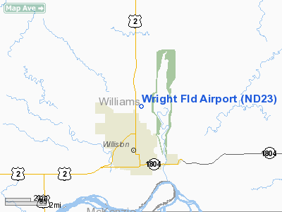
Location & QuickFacts
| FAA Information Effective: | 2008-09-25 |
| Airport Identifier: | ND23 |
| Airport Status: | Operational |
| Longitude/Latitude: | 103-37-12.7060W/48-11-17.0850N
-103.620196/48.188079 (Estimated) |
| Elevation: | 1885 ft / 574.55 m (Estimated) |
| Land: | 85 acres |
| From nearest city: | 3 nautical miles N of Williston, ND |
| Location: | Williams County, ND |
| Magnetic Variation: | 12E (1985) |
Owner & Manager
| Ownership: | Privately owned |
| Owner: | Aero Spraying Service Inc |
| Address: | 4622 Second Ave W
Williston, ND 58801 |
| Phone number: | 701-572-3514 |
| Manager: | Richard Marburger |
| Address: | 4622 Second Ave W
Williston, ND 58801 |
| Phone number: | 701-774-0230
AMGR HOME PHONE 701-774-0230 |
Airport Operations and Facilities
| Airport Use: | Private |
| Wind indicator: | Yes |
| Segmented Circle: | Yes |
| Control Tower: | No |
| Landing fee charge: | No |
| Sectional chart: | Billings |
| Region: | AGL - Great Lakes |
| Boundary ARTCC: | ZLC - Salt Lake City |
| Tie-in FSS: | GFK - Grand Forks |
| FSS on Airport: | No |
| FSS Toll Free: | 1-800-WX-BRIEF |
Airport Services
| Airframe Repair: | NONE |
| Power Plant Repair: | NONE |
| Bottled Oxygen: | NONE |
| Bulk Oxygen: | NONE |
Runway Information
Runway 06/24
| Dimension: | 2300 x 70 ft / 701.0 x 21.3 m |
| Surface: | GRVL-TURF, Poor Condition |
| |
Runway 06 |
Runway 24 |
| Traffic Pattern: | Left | Right |
| Markings: | None, | None, |
| Runway End Identifier: | No | No |
| Centerline Lights: | No | No |
| Touchdown Lights: | No | No |
| Obstruction: | 10 ft bldgs, 40.0 ft from runway, 30 ft right of centerline, 4:1 slope to clear | 50 ft trees, 300.0 ft from runway, 50 ft right of centerline, 6:1 slope to clear |
|
Runway 11/29
| Dimension: | 2250 x 50 ft / 685.8 x 15.2 m |
| Surface: | TURF, Poor Condition |
| |
Runway 11 |
Runway 29 |
| Traffic Pattern: | Left | Right |
| Markings: | None, | None, |
| Runway End Identifier: | No | No |
| Centerline Lights: | No | No |
| Touchdown Lights: | No | No |
| Obstruction: | 60 ft trees, 300.0 ft from runway, 50 ft left of centerline, 5:1 slope to clear | 5 ft fence, 10.0 ft from runway, 30 ft left of centerline, 2:1 slope to clear |
|
Runway 16/35
| Dimension: | 2800 x 70 ft / 853.4 x 21.3 m |
| Surface: | TURF, Poor Condition |
| |
Runway 16 |
Runway 35 |
| Traffic Pattern: | Left | Right |
| Markings: | None, | None, |
| Runway End Identifier: | No | No |
| Centerline Lights: | No | No |
| Touchdown Lights: | No | No |
| Obstruction: | 60 ft trees, 200.0 ft from runway, 3:1 slope to clear | 30 ft trees, 75.0 ft from runway, 80 ft right of centerline, 2:1 slope to clear |
|
Radio Navigation Aids
| ID |
Type |
Name |
Ch |
Freq |
Var |
Dist |
| ISN | NDB | Williston | | 275.00 | 15E | 2.9 nm |
| SDY | NDB | Sidney | | 359.00 | 12E | 36.5 nm |
| ISN | VORTAC | Williston | 110X | 116.30 | 12E | 6.5 nm |
Remarks
-
-
- TURF RYS & APRONS HAVE SOME ROUGH SPOTS WITH POSSIBLE HOLES AND CLUMPY GRASS.
- RY 06/24 20 FT WIDE GRAVEL STRIP ON CNTRLN.
- ARPT CLSD NOV-APR DUE TO LACK OF SNOW REMOVAL.
- -15 FT DROPOF 50 FT FROM THR.
- EXISTED PRIOR TO 1959.
Images and information placed above are from
http://www.airport-data.com/airport/ND23/
We thank them for the data!
|
|


