 |
|
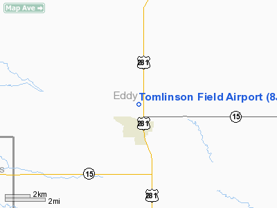
Location & QuickFacts
| FAA Information Effective: | 2008-09-25 |
| Airport Identifier: | 8J7 |
| Airport Status: | Operational |
| Longitude/Latitude: | 099-07-52.4230W/47-41-46.9940N
-99.131229/47.696387 (Estimated) |
| Elevation: | 1533 ft / 467.26 m (Estimated) |
| Land: | 185 acres |
| From nearest city: | 1 nautical miles N of New Rockford, ND |
| Location: | Eddy County, ND |
| Magnetic Variation: | 08E (1985) |
Owner & Manager
| Ownership: | Publicly owned |
| Owner: | City Of New Rockford |
| Address: | Box 752
New Rockford, ND 58356 |
| Phone number: | 701-947-5323
AIRPORT AUTHORITY CHAIRMAN. |
| Manager: | Erling Rolfson
AIRPORT AUTHORITY MEMBER. |
| Address: | Box 255
New Rockford, ND 58356 |
| Phone number: | 701-947-2417
HOME PHONE (701) 947-5251 OR CELL 302-0159 |
Airport Operations and Facilities
| Airport Use: | Open to public |
| Wind indicator: | Yes |
| Segmented Circle: | Yes |
| Control Tower: | No |
| Lighting Schedule: | DUSK-DAWN |
| Beacon Color: | Clear-Green (lighted land airport) |
| Landing fee charge: | No |
| Sectional chart: | Twin Cities |
| Region: | AGL - Great Lakes |
| Boundary ARTCC: | ZMP - Minneapolis |
| Tie-in FSS: | GFK - Grand Forks |
| FSS on Airport: | No |
| FSS Toll Free: | 1-800-WX-BRIEF |
| NOTAMs Facility: | GFK (NOTAM-d service avaliable) |
| Federal Agreements: | 1 |
Airport Communications
Airport Services
| Bottled Oxygen: | NONE |
| Bulk Oxygen: | NONE |
Runway Information
Runway 13/31
| Dimension: | 3600 x 60 ft / 1097.3 x 18.3 m |
| Surface: | ASPH, Good Condition |
| Weight Limit: | Single wheel: 12500 lbs.
RY 13/31 SW LIMITED TO 4000 LBS PER AMGR ON APRON ONLY. |
| Edge Lights: | Low |
| |
Runway 13 |
Runway 31 |
| Longitude: | 099-08-08.4200W | 099-07-38.2900W |
| Latitude: | 47-42-00.9900N | 47-41-31.8600N |
| Elevation: | 1533.00 ft | 1526.00 ft |
| Traffic Pattern: | Left | Left |
| Markings: | Basic, Good Condition
. | Basic, Good Condition |
| Runway End Identifier: | No | No |
| Centerline Lights: | No | No |
| Touchdown Lights: | No | No |
| Obstruction: | 25 ft rr, 500.0 ft from runway, 175 ft right of centerline, 12:1 slope to clear
+1'DIRT TRAIL 150'FM RWY END 125'R & ANGLES TO 300'FM RWY END ON CL. | 18 ft road, 450.0 ft from runway, 150 ft right of centerline, 13:1 slope to clear |
|
Radio Navigation Aids
| ID |
Type |
Name |
Ch |
Freq |
Var |
Dist |
| DVL | VOR/DME | Devils Lake | 047X | 111.00 | 07E | 26.7 nm |
| JMS | VOR/DME | Jamestown | 092X | 114.50 | 10E | 49.5 nm |
Remarks
- ADDNL CTC TODD GEORGESON (701) 947-2640 OR GEORGE RITZKE 701-947-2461.
- CONFIRM SNOW REMOVAL & WINTER CONDITION WITH ARPT MGR.
- 200' OUTBOARD THR SAFETY AREA CULTIVATED AND ROUGH.
- ASPH APRON SFC POOR WITH POT HOLES & RUTS ON WEST SIDE APRON ONLY.
- TWY LGTS NOT AVBL.
- EXISTED PRIOR TO 1959.
Images and information placed above are from
http://www.airport-data.com/airport/8J7/
We thank them for the data!
|
|


