 |
|
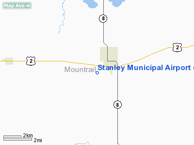
Location & QuickFacts
| FAA Information Effective: | 2008-09-25 |
| Airport Identifier: | 08D |
| Airport Status: | Operational |
| Longitude/Latitude: | 102-24-22.8650W/48-18-02.8750N
-102.406351/48.300799 (Estimated) |
| Elevation: | 2245 ft / 684.28 m (Surveyed) |
| Land: | 80 acres |
| From nearest city: | 1 nautical miles SW of Stanley, ND |
| Location: | Mountrail County, ND |
| Magnetic Variation: | 10E (2000) |
Owner & Manager
| Ownership: | Publicly owned |
| Owner: | Stanley Arpt Auth
DAN LINDBERG -APT CHRMN |
| Address: | Box 577
Stanley, ND 58784 |
| Phone number: | 701-628-3129 |
| Manager: | Jay Mackey |
| Address: | Box 892
Stanley, ND 58784 |
| Phone number: | 701-628-2950
ARPT MGR CELL PHONE 701-629-1950 |
Airport Operations and Facilities
| Airport Use: | Open to public |
| Wind indicator: | Yes |
| Segmented Circle: | Yes |
| Control Tower: | No |
| Lighting Schedule: | DUSK-DAWN
ACTVT MIRL RY 09/27 & PAPI RY 27 - CTAF. |
| Beacon Color: | Clear-Green (lighted land airport) |
| Landing fee charge: | No |
| Sectional chart: | Billings |
| Region: | AGL - Great Lakes |
| Boundary ARTCC: | ZMP - Minneapolis |
| Tie-in FSS: | GFK - Grand Forks |
| FSS on Airport: | No |
| FSS Toll Free: | 1-800-WX-BRIEF |
| NOTAMs Facility: | GFK (NOTAM-d service avaliable) |
| Federal Agreements: | NGY |
Airport Communications
Airport Services
| Fuel available: | 100LLA
SELF SERVICE 24 HR CREDIT CARD FUELING SYSTEM AVBL. |
| Airframe Repair: | MINOR |
| Power Plant Repair: | MINOR |
| Bottled Oxygen: | NONE |
| Bulk Oxygen: | NONE |
Runway Information
Runway 09/27
| Dimension: | 3900 x 60 ft / 1188.7 x 18.3 m |
| Surface: | ASPH, Good Condition |
| Weight Limit: | Single wheel: 14000 lbs. |
| Edge Lights: | Medium |
| |
Runway 09 |
Runway 27 |
| Longitude: | 102-24-50.2690W | 102-23-55.4600W |
| Latitude: | 48-18-08.8710N | 48-17-56.8800N |
| Elevation: | 2245.00 ft | 2240.00 ft |
| Alignment: | 108 | 127 |
| Traffic Pattern: | Left | Left |
| Markings: | Non-precision instrument, Good Condition | Non-precision instrument, Good Condition |
| Crossing Height: | 0.00 ft | 32.00 ft |
| VASI: | | 2-light PAPI on left side |
| Visual Glide Angle: | 0.00° | 3.00° |
| Obstruction: | 3 ft pole, 300.0 ft from runway, 80 ft left of centerline, 33:1 slope to clear | 14 ft road, 530.0 ft from runway, 150 ft right of centerline, 23:1 slope to clear |
|
Radio Navigation Aids
| ID |
Type |
Name |
Ch |
Freq |
Var |
Dist |
| PSH | NDB | Parshall | | 379.00 | 11E | 24.4 nm |
| HBC | NDB | Mohall | | 350.00 | 11E | 44.4 nm |
| ISN | NDB | Williston | | 275.00 | 15E | 48.1 nm |
| MIB | TACAN | Deering | 096X | | 10E | 42.1 nm |
| MOT | VORTAC | Minot | 118X | 117.10 | 13E | 44.8 nm |
Remarks
- DUE TO SNOW NOV-MAR CALL 701-628-2110 OR 629-2130 TO CHECK ON RY CONDITION PRIOR TO USE.
- DEER & BIRDS ON & INVOF ARPT.
Images and information placed above are from
http://www.airport-data.com/airport/08D/
We thank them for the data!
|
|


