 |
|
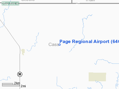
Location & QuickFacts
| FAA Information Effective: | 2008-09-25 |
| Airport Identifier: | 64G |
| Airport Status: | Operational |
| Longitude/Latitude: | 097-28-49.3190W/47-10-10.9380N
-97.480366/47.169705 (Estimated) |
| Elevation: | 1215 ft / 370.33 m (Estimated) |
| Land: | 26 acres |
| From nearest city: | 4 nautical miles E of Page, ND |
| Location: | Cass County, ND |
| Magnetic Variation: | 07E (1985) |
Owner & Manager
| Ownership: | Privately owned
PROPERTY LEASED TO PAGE REGIONAL ARPT AUTHORITY. |
| Owner: | Tim Mcpherson |
| Address: | 14269 17th St S.e.
Page, ND 58064 |
| Phone number: | 701-668-2302 |
| Manager: | Tim Mcpherson |
| Address: | 14269 17th St S.e.
Page, ND 58064 |
| Phone number: | 701-668-2302
AMGR HOME PHONE 701-668-2302 OR CELL 701-799-8629 |
Airport Operations and Facilities
| Airport Use: | Open to public |
| Wind indicator: | Yes |
| Segmented Circle: | No |
| Control Tower: | No |
| Lighting Schedule: | RDO-CTL
ACTVT LIRL RY 17/35 5 CLICKS ON - 8 CLICKS OFF - CTAF. |
| Sectional chart: | Twin Cities |
| Region: | AGL - Great Lakes |
| Boundary ARTCC: | ZMP - Minneapolis |
| Tie-in FSS: | GFK - Grand Forks |
| FSS Toll Free: | 1-800-WX-BRIEF |
| NOTAMs Facility: | (NOTAM-d service avaliable) |
Airport Communications
Airport Services
| Fuel available: | 100LL
FOR FUEL CALL 701-668-2302. |
| Airframe Repair: | MAJOR |
| Power Plant Repair: | MAJOR |
Runway Information
Runway 17/35
| Dimension: | 2600 x 30 ft / 792.5 x 9.1 m |
| Surface: | ASPH, Fair Condition |
| Edge Lights: | Non-standard lighting system
NSTD LIRL FIXTURES 400 FT SPACING BETWEEN LGTS; THLD LGTS ARE GREEN ONLY. |
| |
Runway 17 |
Runway 35 |
| Traffic Pattern: | Left | Left |
| Markings: | Nonstandard, Fair Condition
17/35 WHITE CNTRLN STRIPE ONLY; NSTD SPACING. | Nonstandard, Fair Condition |
| Obstruction: | , 50:1 slope to clear | 35 ft trees, 900.0 ft from runway, 175 ft right of centerline, 20:1 slope to clear
+17 FT ROAD 30 FT FM THLD; +30 FT POLE 100 FT FM THLD & 100 FT L OF EXTDD CNTRLN. |
|
Radio Navigation Aids
| ID |
Type |
Name |
Ch |
Freq |
Var |
Dist |
| VCY | NDB | Valley City | | 382.00 | 07E | 25.0 nm |
| AA | NDB | Kenie | | 365.00 | 06E | 28.9 nm |
| RDR | TACAN | Red River | 111X | | 06E | 47.4 nm |
| GFK | VOR/DME | Grand Forks | 090X | 114.30 | 09E | 48.7 nm |
| FAR | VORTAC | Fargo | 109X | 116.20 | 09E | 35.9 nm |
Remarks
- RY 17/35 HAS CULTIVATED FIELDS AT BOTH ENDS.
- TRAFFIC PATTERN CONFLICT WITH CONRAD & THOMPSON ARPTS. IN ADDITION MAN-MADE OR NATURAL OBJECTS OBSTRUCT.
Images and information placed above are from
http://www.airport-data.com/airport/64G/
We thank them for the data!
| General Info
|
| Country |
United States
|
| State |
NORTH DAKOTA
|
| FAA ID |
64G
|
| Latitude |
47-10-10.938N
|
| Longitude |
097-28-49.319W
|
| Elevation |
1215 feet
|
| Near City |
PAGE
|
We don't guarantee the information is fresh and accurate. The data may
be wrong or outdated.
For more up-to-date information please refer to other sources.
|
|


