 |
|
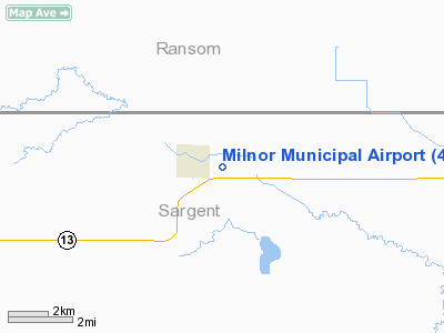
Location & QuickFacts
| FAA Information Effective: | 2008-09-25 |
| Airport Identifier: | 4R6 |
| Airport Status: | Operational |
| Longitude/Latitude: | 097-26-16.3270W/46-15-29.8590N
-97.437869/46.258294 (Estimated) |
| Elevation: | 1091 ft / 332.54 m (Estimated) |
| Land: | 19 acres |
| From nearest city: | 1 nautical miles E of Milnor, ND |
| Location: | Sargent County, ND |
| Magnetic Variation: | 07E (1985) |
Owner & Manager
| Ownership: | Publicly owned |
| Owner: | City Of Milnor |
| Address: | Po Box 70
Milnor, ND 58060 |
| Phone number: | 701-427-5272 |
| Manager: | Harris Lunneborg
CHRMN OF APT AUTH. |
| Address: | 13671 Hwy 13
Milnor, ND 58060 |
| Phone number: | 701-427-5578
APT MGR CELL 701-678-4487 |
Airport Operations and Facilities
| Airport Use: | Open to public |
| Wind indicator: | Yes |
| Segmented Circle: | No |
| Control Tower: | No |
| Lighting Schedule: | DUSK-0100
FOR LIRL RY 08/26 AFTER 0100 CONTACT AMGR ON 701-427-5578 OR 701-678-4487. |
| Landing fee charge: | No |
| Sectional chart: | Twin Cities |
| Region: | AGL - Great Lakes |
| Boundary ARTCC: | ZMP - Minneapolis |
| Tie-in FSS: | GFK - Grand Forks |
| FSS on Airport: | No |
| FSS Toll Free: | 1-800-WX-BRIEF |
| NOTAMs Facility: | GFK (NOTAM-d service avaliable) |
Airport Communications
Airport Services
| Airframe Repair: | NONE |
| Power Plant Repair: | NONE |
Runway Information
Runway 08/26
| Dimension: | 2210 x 90 ft / 673.6 x 27.4 m |
| Surface: | TURF, Fair Condition |
| Edge Lights: | Low
LIRL OTS INDEFLY. |
| |
Runway 08 |
Runway 26 |
| Longitude: | 097-26-44.3300W | 097-26-12.8800W |
| Latitude: | 46-15-37.8600N | 46-15-37.8600N |
| Elevation: | 1090.00 ft | 1090.00 ft |
| Traffic Pattern: | Left | Left |
| Obstruction: | 200 ft bldg, 3400.0 ft from runway, 400 ft right of centerline, 17:1 slope to clear | 30 ft trees, 60.0 ft from runway, 125 ft left of centerline, 2:1 slope to clear |
|
Radio Navigation Aids
| ID |
Type |
Name |
Ch |
Freq |
Var |
Dist |
| GWR | NDB | Gwinner | | 278.00 | 07E | 8.8 nm |
| BTN | NDB | Britton | | 386.00 | 06E | 29.4 nm |
| BWP | NDB | Breckenridge-wahpeton | | 233.00 | 05E | 34.7 nm |
| VCY | NDB | Valley City | | 382.00 | 07E | 42.1 nm |
| ETH | NDB | Wheaton | | 326.00 | 05E | 46.9 nm |
| FAR | VORTAC | Fargo | 109X | 116.20 | 09E | 38.4 nm |
Remarks
- CONFIRM ARPT COND PRIOR TO LANDING DUE TO IREG SNOW REMOVAL; PHONE REQUEST ONLY 701-427-9249/5272/5578/5264.
- RY 08/26 HAS +4 FT FENCE 60 FT S & PARALLEL CNTRLN IN TRANSITION SURFACE.
- RY 08/26 HAS 250' TURF STWY WEST END.
- RY 08/26 CROSSWIND TURBULENCE POSSIBLE DUE TO CLOSE PROXIMITY TREE GROWTH.
- RY 08 +15 FT RD 280 FT FM THLD ON CNTRLN; APCH RATIO 18:1.
- RY 26 +4 FT FENCE 30 FT FM THLD ON CNTRLN; APCH RATIO 7:1.
- RY 26 HAS+10 FT PRIVATE ROAD 50 FT FM THLD ON CNTRLN APCH RATIO 5:1.
- EXISTED PRIOR TO 1959.
Images and information placed above are from
http://www.airport-data.com/airport/4R6/
We thank them for the data!
| General Info
|
| Country |
United States
|
| State |
NORTH DAKOTA
|
| FAA ID |
4R6
|
| Latitude |
46-15-29.859N
|
| Longitude |
097-26-16.327W
|
| Elevation |
1091 feet
|
| Near City |
MILNOR
|
We don't guarantee the information is fresh and accurate. The data may
be wrong or outdated.
For more up-to-date information please refer to other sources.
|
|


