 |
|
| Jamestown Regional Airport |
| IATA: JMS – ICAO: KJMS |
| Summary |
| Airport type |
Public |
| Operator |
Jamestown Airport Authority |
| Location |
Jamestown, North Dakota |
| Elevation AMSL |
1,498 ft / 456.6 m |
| Coordinates |
46°55′47″N 98°40′42″W / 46.92972°N 98.67833°W / 46.92972; -98.67833 |
| Runways |
| Direction |
Length |
Surface |
| ft |
m |
| 13/31 |
6,500 |
1,981 |
Asphalt |
| 4/22 |
5,749 |
1,752 |
Asphalt |
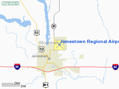
Jamestown Regional Airport (IATA: JMS, ICAO: KJMS) is a public airport located two miles (3 km) northeast of the central business district (CBD) of Jamestown, a city in Stutsman County, North Dakota, USA. The airport covers 1,500 acres (607 ha) and has two runways. It is mostly used for general aviation but is also served by one commercial airline, with flights twice each weekday and once on Saturdays and Sundays. Service is subsidized by the Essential Air Service program.
Airlines and destinations
| Airlines |
Destinations |
| Delta Connection operated by Mesaba Airlines |
Devil's Lake, Minneapolis/St. Paul |
The above content comes from Wikipedia and is published under free licenses – click here to read more.
Location & QuickFacts
| FAA Information Effective: | 2008-09-25 |
| Airport Identifier: | JMS |
| Airport Status: | Operational |
| Longitude/Latitude: | 098-40-41.5000W/46-55-47.0000N
-98.678194/46.929722 (Estimated) |
| Elevation: | 1500 ft / 457.20 m (Surveyed) |
| Land: | 1500 acres |
| From nearest city: | 2 nautical miles NE of Jamestown, ND |
| Location: | Stutsman County, ND |
| Magnetic Variation: | 08E (1990) |
Owner & Manager
| Ownership: | Publicly owned |
| Owner: | Jamestown Rgnl Arpt Authority |
| Address: | Po Box 1560
Jamestown, ND 58402 |
| Phone number: | 701-252-6466 |
| Manager: | Jennifer Eckman |
| Address: | Po Box 1560
Jamestown, ND 58402 |
| Phone number: | 701-252-6466
AFT HRS CALL 701-320-6466. |
Airport Operations and Facilities
| Airport Use: | Open to public |
| Wind indicator: | Yes |
| Segmented Circle: | Yes |
| Control Tower: | No |
| Lighting Schedule: | DUSK-DAWN
ACTVT MIRL RY 04/22; HIRL RY 13/31; MALSR RY 31; VASI RY 13; REIL RYS 13, 04 & 22, PAPI RYS O4, 22 & 31 - CTAF. |
| Beacon Color: | Clear-Green (lighted land airport) |
| Landing fee charge: | No |
| Sectional chart: | Twin Cities |
| Region: | AGL - Great Lakes |
| Boundary ARTCC: | ZMP - Minneapolis |
| Tie-in FSS: | GFK - Grand Forks |
| FSS on Airport: | No |
| FSS Toll Free: | 1-800-WX-BRIEF |
| NOTAMs Facility: | JMS (NOTAM-d service avaliable) |
| Certification type/date: | I A S 05/1973
48 HRS PPR FOR UNSKED ACR OPNS WITH MORE THAN 9 PSGR SEATS CALL AMGR 701-252-6466. ACR OPS INVOLVING ACFT WITH MORE THAN 9 PSGRS NOT AUZD IN EXCESS OF 15 MINS BEFORE OR AFTER SKED ARR/DEP TIMES WITHOUT PRIOR COORDINATION WITH AMGR AND CONFIRMATION THAT ARFF IS AVBL PRIOR TO LANDING OR TAKEOFF. |
| Federal Agreements: | NGY3 |
Airport Communications
| CTAF: | 123.000 |
| Unicom: | 123.000 |
Airport Services
| Fuel available: | 100LLA
100LL AVBL 24 HRS WITH CREDIT CARD. |
| Airframe Repair: | MAJOR |
| Power Plant Repair: | MAJOR |
| Bottled Oxygen: | HIGH |
Runway Information
Runway 04/22
| Dimension: | 5750 x 75 ft / 1752.6 x 22.9 m |
| Surface: | ASPH, Fair Condition |
| Weight Limit: | Single wheel: 85000 lbs.
Dual wheel: 103000 lbs.
Dual tandem wheel: 162000 lbs. |
| Edge Lights: | Medium |
| |
Runway 04 |
Runway 22 |
| Longitude: | 098-41-11.9601W | 098-40-13.7259W |
| Latitude: | 46-55-28.1858N | 46-56-08.5480N |
| Elevation: | 1494.00 ft | 1500.00 ft |
| Alignment: | 45 | 127 |
| Traffic Pattern: | Left | Left |
| Markings: | Basic, Good Condition | Basic, Good Condition |
| Crossing Height: | 20.00 ft | 20.00 ft |
| VASI: | 4-light PAPI on left side | 4-light PAPI on left side |
| Visual Glide Angle: | 3.00° | 3.00° |
| Runway End Identifier: | Yes | Yes |
| Obstruction: | 34 ft pole, 1777.0 ft from runway, 112 ft left of centerline, 46:1 slope to clear | , 50:1 slope to clear |
|
Runway 13/31
| Dimension: | 6502 x 100 ft / 1981.8 x 30.5 m |
| Surface: | ASPH, |
| Surface Treatment: | Saw-cut or plastic Grooved |
| Weight Limit: | Single wheel: 130000 lbs.
Dual wheel: 160000 lbs.
Dual tandem wheel: 250000 lbs. |
| Edge Lights: | High |
| |
Runway 13 |
Runway 31 |
| Longitude: | 098-41-13.5737W | 098-40-07.0970W |
| Latitude: | 46-56-08.3583N | 46-55-23.1408N |
| Elevation: | 1500.00 ft | 1497.00 ft |
| Alignment: | 127 | 127 |
| ILS Type: | | ILS/DME
|
| Traffic Pattern: | Left | Left |
| Markings: | Non-precision instrument, Good Condition | Precision instrument, Good Condition |
| Crossing Height: | 51.00 ft | 50.00 ft |
| VASI: | 4-box on left side
RESTRICTED TO +/- 8 DEG EITHER SIDE OF CL. | 4-light PAPI on left side |
| Visual Glide Angle: | 3.00° | 3.00° |
| Approach lights: | | MALSR |
| Runway End Identifier: | Yes | |
| Obstruction: | 58 ft tree, 2152.0 ft from runway, 92 ft left of centerline, 33:1 slope to clear | , 50:1 slope to clear |
|
Radio Navigation Aids
| ID |
Type |
Name |
Ch |
Freq |
Var |
Dist |
| VCY | NDB | Valley City | | 382.00 | 07E | 31.5 nm |
| JMS | VOR/DME | Jamestown | 092X | 114.50 | 10E | 0.2 nm |
Remarks
- BIRDS ON AND INVOF ARPT.
- 48 HRS PPR FOR UNSKED ACR OPNS WITH MORE THAN 30 PSGR SEATS CALL AMGR 701-252-0224/701-320-6446.
- 24 HR PILOT LOUNGE AVBL.
- FOR ATTENDANT AFTER HOURS, CALL 701-252-0224.
- PAEW ADJ TO ALL RYS.
Images and information placed above are from
http://www.airport-data.com/airport/JMS/
We thank them for the data!
| General Info
|
| Country |
United States
|
| State |
NORTH DAKOTA
|
| FAA ID |
JMS
|
| Latitude |
46-55-46.990N
|
| Longitude |
098-40-41.503W
|
| Elevation |
1498 feet
|
| Near City |
JAMESTOWN
|
We don't guarantee the information is fresh and accurate. The data may
be wrong or outdated.
For more up-to-date information please refer to other sources.
|
|


