 |
|
| Hettinger Municipal Airport |
| IATA: none – ICAO: KHEI – FAA LID: HEI |
| Summary |
| Airport type |
Public |
| Owner |
Adams County Airport Authority |
| Serves |
Hettinger, North Dakota |
| Elevation AMSL |
2,705 ft / 824 m |
| Coordinates |
46°00′54″N 102°39′22″W / 46.015°N 102.65611°W / 46.015; -102.65611 |
| Runways |
| Direction |
Length |
Surface |
| ft |
m |
| 12/30 |
4,652 |
1,418 |
Asphalt |
| 17/35 |
1,890 |
576 |
Turf |
| Statistics (2006) |
| Aircraft operations |
2,830 |
| Based aircraft |
25 |
| Source: Federal Aviation Administration |
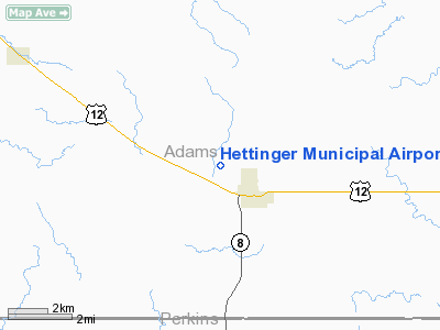
Hettinger Municipal Airport (ICAO: KHEI, FAA LID: HEI) is a public use airport located in Adams County, North Dakota, United States and owned by the Adams County Airport Authority. The airport is one nautical mile (1.85 km) northwest of the central business district of Hettinger, North Dakota.
Although most U.S. airports use the same three-letter location identifier for the FAA and IATA, this airport is assigned HEI by the FAA but has no designation from the IATA (which assigned HEI to Heide-Büsum Airport in Heide, Germany).
Facilities and aircraft
Hettinger Municipal Airport covers an area of 271 acres (110 ha) at an elevation of 2,705 feet (824 m) above mean sea level. It has two runways: 12/30 is 4,652 by 75 feet (1,418 x 23 m) with an asphalt surface; 17/35 is 1,890 by 100 feet (576 x 30 m) with a turf surface.
For the 12-month period ending July 20, 2006, the airport had 2,830 aircraft operations, an average of 235 per month: 88% general aviation, 11% air taxi and 1% military. At that time there were 25 aircraft based at this airport: 96% single-engine and 4% multi-engine.
The above content comes from Wikipedia and is published under free licenses – click here to read more.
Location & QuickFacts
| FAA Information Effective: | 2008-09-25 |
| Airport Identifier: | HEI |
| Airport Status: | Operational |
| Longitude/Latitude: | 102-39-21.5000W/46-00-53.8000N
-102.655972/46.014944 (Estimated) |
| Elevation: | 2705 ft / 824.48 m (Surveyed) |
| Land: | 271 acres |
| From nearest city: | 1 nautical miles NW of Hettinger, ND |
| Location: | Adams County, ND |
| Magnetic Variation: | 12E (1980) |
Owner & Manager
| Ownership: | Publicly owned |
| Owner: | Adams Co Arpt Auth
LA VERNE STIPPICH, PRES - 701-567-2666/2590. |
| Address: | Box 670
Hettinger, ND 58639 |
| Phone number: | 701-567-2666 |
| Manager: | J. B. Lindquist |
| Address: | Po Box 429
Hettinger, ND 58639 |
| Phone number: | 701-567-2069
ADDL CTC AFT HRS CHARLES LINDQUIST 701-567-4469. |
Airport Operations and Facilities
| Airport Use: | Open to public |
| Wind indicator: | Yes
WINDSOCKS LOCATED EACH END OF RWY 12/30. |
| Segmented Circle: | Yes |
| Control Tower: | No |
| Lighting Schedule: | DUSK-DAWN
MIRL RY 12/30 PRESET LOW INTST DUSK-2330; AFT 2330 ACTVT - CTAF. TO INCR INTST & ACTVT PAPI RYS 12 & 30 - CTAF. |
| Beacon Color: | Clear-Green (lighted land airport)
ROTG BCN OTS INDEFLY. |
| Landing fee charge: | No |
| Sectional chart: | Billings |
| Region: | AGL - Great Lakes |
| Boundary ARTCC: | ZMP - Minneapolis |
| Tie-in FSS: | GFK - Grand Forks |
| FSS on Airport: | No |
| FSS Toll Free: | 1-800-WX-BRIEF |
| NOTAMs Facility: | HEI (NOTAM-d service avaliable) |
| Federal Agreements: | NGY |
Airport Communications
| CTAF: | 122.800 |
| Unicom: | 122.800 |
Airport Services
| Fuel available: | 100LLA
24-HR SELF- SERVICE FUEL AVBL WITH CREDIT CARD. |
| Airframe Repair: | MAJOR |
| Power Plant Repair: | MAJOR |
| Bottled Oxygen: | NONE |
| Bulk Oxygen: | NONE |
Runway Information
Runway 12/30
| Dimension: | 4652 x 75 ft / 1417.9 x 22.9 m |
| Surface: | ASPH, Good Condition |
| Weight Limit: | Single wheel: 11500 lbs. |
| Edge Lights: | Medium |
| |
Runway 12 |
Runway 30 |
| Longitude: | 102-39-43.2740W | 102-38-57.1520W |
| Latitude: | 46-01-12.8940N | 46-00-40.0920N |
| Elevation: | 2704.00 ft | 2698.00 ft |
| Alignment: | 127 | 127 |
| Traffic Pattern: | Left | Left |
| Markings: | Non-precision instrument, Good Condition | Non-precision instrument, Good Condition |
| Crossing Height: | 25.00 ft | 25.00 ft |
| VASI: | 2-light PAPI on left side | 2-light PAPI on left side |
| Visual Glide Angle: | 3.00° | 3.00° |
| Runway End Identifier: | No | No |
| Centerline Lights: | No | No |
| Touchdown Lights: | No | No |
| Obstruction: | 4 ft fence, 300.0 ft from runway, 150 ft right of centerline, 25:1 slope to clear | 4 ft fence, 225.0 ft from runway, 150 ft left of centerline, 6:1 slope to clear |
|
Runway 17/35
| Dimension: | 1890 x 100 ft / 576.1 x 30.5 m |
| Surface: | TURF, Good Condition |
| |
Runway 17 |
Runway 35 |
| Traffic Pattern: | Left | Left |
| Runway End Identifier: | No | No |
| Centerline Lights: | No | No |
| Touchdown Lights: | No | No |
| Obstruction: | , 50:1 slope to clear | 5 ft fence, 25.0 ft from runway, 5:1 slope to clear |
|
Radio Navigation Aids
| ID |
Type |
Name |
Ch |
Freq |
Var |
Dist |
| HEI | NDB | Hettinger | | 392.00 | 12E | 0.3 nm |
| BOD | NDB | Bowman | | 374.00 | 10E | 33.8 nm |
| LEM | VOR | Lemmon | | 111.40 | 13E | 23.8 nm |
| BUA | VOR/DME | Buffalo | 031X | 109.40 | 13E | 43.6 nm |
Remarks
- CONFIRM WINTER COND RY 17/35 CALL AMGR 701-567-2069.
- TWYS ILLUMINATED WITH REFLECTORS FOR NIGHTIME USE.
- DEER ON & INVOF ARPT.
- AIRSPACE 73-RM-68-NRA.
Images and information placed above are from
http://www.airport-data.com/airport/HEI/
We thank them for the data!
| General Info
|
| Country |
United States
|
| State |
NORTH DAKOTA
|
| FAA ID |
HEI
|
| Latitude |
46-00-53.800N
|
| Longitude |
102-39-21.500W
|
| Elevation |
2705 feet
|
| Near City |
HETTINGER
|
We don't guarantee the information is fresh and accurate. The data may
be wrong or outdated.
For more up-to-date information please refer to other sources.
|
|


