 |
|
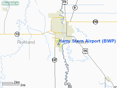
| Harry Stern Airport |
| IATA: WAH – ICAO: KBWP – FAA LID: BWP |
| Summary |
| Airport type |
Public |
| Owner |
Wahpeton Airport Authority |
| Serves |
Wahpeton, North Dakota |
| Elevation AMSL |
968 ft / 295 m |
| Coordinates |
46°14′39″N 096°36′26″W / 46.24417°N 96.60722°W / 46.24417; -96.60722 |
| Runways |
| Direction |
Length |
Surface |
| ft |
m |
| 15/33 |
5,100 |
1,554 |
Asphalt |
| 3/21 |
3,254 |
992 |
Turf |
| Statistics (2003) |
| Aircraft operations |
10,860 |
| Based aircraft |
66 |
| Source: Federal Aviation Administration |
Harry Stern Airport (IATA: WAH, ICAO: KBWP, FAA LID: BWP) is a public use airport in Richland County, North Dakota, United States. It is located one nautical mile (1.85 km) south of the central business district of Wahpeton, North Dakota and owned by the Wahpeton Airport Authority.
Although most U.S. airports use the same three-letter location identifier for the FAA and IATA, Enterprise Municipal Airport is assigned BWP by the FAA and WAH by the IATA (which assigned BWP to Bewani, Papua New Guinea).
Facilities and aircraft
Harry Stern Airport covers an area of 585 acres (237 ha) at an elevation of 968 feet (295 m) above mean sea level. It has two runways: 15/33 is 5,100 by 75 feet (1,554 x 23 m) with an asphalt surface; 3/21 is 3,254 by 150 feet (992 x 46 m) with a turf surface.
For the 12-month period ending December 3, 2003, the airport had 10,860 aircraft operations, an average of 29 per day: 92% general aviation and 7% air taxi and 1% military. At that time there were 66 aircraft based at this airport: 83% single-engine, 8% multi-engine, 1% helicopter and 8% military.
The above content comes from Wikipedia and is published under free licenses – click here to read more.
Location & QuickFacts
| FAA Information Effective: | 2008-09-25 |
| Airport Identifier: | BWP |
| Airport Status: | Operational |
| Longitude/Latitude: | 096-36-25.7614W/46-14-39.4576N
-96.607156/46.244294 (Estimated) |
| Elevation: | 968 ft / 295.05 m (Surveyed) |
| Land: | 585 acres |
| From nearest city: | 1 nautical miles S of Wahpeton, ND |
| Location: | Richland County, ND |
| Magnetic Variation: | 05E (1995) |
Owner & Manager
| Ownership: | Publicly owned |
| Owner: | Wahpeton Arpt Auth
CHRMN JIM ALDRICH 701-642-3151 |
| Address: | 1251 Pegasus Road
Wahpeton, ND 58074 |
| Phone number: | 701-642-8703
SEC/TREASURER FOR APT AUTH |
| Manager: | Cindy Schreiber-beck |
| Address: | Po Box 843
Wahpeton, ND 58074 |
| Phone number: | 701-642-5777
ADDNL PHONE 701-642-3232 OR CITY POLICE 701-642-7777. |
Airport Operations and Facilities
| Airport Use: | Open to public |
| Wind indicator: | Yes |
| Segmented Circle: | Yes |
| Control Tower: | No |
| Lighting Schedule: | DUSK-DAWN
MIRL RY 15/33 PRESET LOW INTST TO INCR INTST & ACTVT REIL & PAPI RYS 15 & 33 - CTAF. |
| Beacon Color: | Clear-Green (lighted land airport) |
| Landing fee charge: | No |
| Sectional chart: | Twin Cities |
| Region: | AGL - Great Lakes |
| Boundary ARTCC: | ZMP - Minneapolis |
| Tie-in FSS: | GFK - Grand Forks |
| FSS on Airport: | No |
| FSS Toll Free: | 1-800-WX-BRIEF |
| NOTAMs Facility: | GFK (NOTAM-d service avaliable) |
| Federal Agreements: | NGY |
Airport Communications
| CTAF: | 123.000 |
| Unicom: | 123.000 |
Airport Services
| Fuel available: | 100LLA
SELF-SERVICE CREDIT CARD FUEL SYSTEM AVBL 24 HOURS. |
| Airframe Repair: | MAJOR |
| Power Plant Repair: | MAJOR |
| Bottled Oxygen: | NONE |
| Bulk Oxygen: | NONE |
Runway Information
Runway 03/21
| Dimension: | 3254 x 150 ft / 991.8 x 45.7 m |
| Surface: | TURF, Fair Condition |
| |
Runway 03 |
Runway 21 |
| Longitude: | 096-36-40.3443W | 096-36-12.1115W |
| Latitude: | 46-14-27.1721N | 46-14-52.6275N |
| Elevation: | 967.00 ft | 965.00 ft |
| Alignment: | 38 | 127 |
| Traffic Pattern: | Left | Left |
| Obstruction: | 40 ft trees, 800.0 ft from runway, 250 ft right of centerline, 20:1 slope to clear | 200 ft tower, 5000.0 ft from runway, 250 ft right of centerline, 25:1 slope to clear |
|
Runway 15/33
| Dimension: | 5100 x 75 ft / 1554.5 x 22.9 m |
| Surface: | ASPH, Good Condition |
| Weight Limit: | Single wheel: 20000 lbs. |
| Edge Lights: | Medium |
| |
Runway 15 |
Runway 33 |
| Longitude: | 096-36-40.2548W | 096-36-10.6728W |
| Latitude: | 46-15-02.1578N | 46-14-16.1931N |
| Elevation: | 968.00 ft | 966.00 ft |
| Alignment: | 127 | 127 |
| Traffic Pattern: | Left | Left |
| Markings: | Non-precision instrument, Good Condition | Non-precision instrument, Good Condition |
| Crossing Height: | 24.00 ft | 24.00 ft |
| VASI: | 2-light PAPI on left side | 2-light PAPI on left side |
| Visual Glide Angle: | 3.00° | 3.00° |
| Runway End Identifier: | Yes | Yes |
| Obstruction: | 52 ft tree, 1400.0 ft from runway, 250 ft left of centerline, 23:1 slope to clear | 41 ft trees, 1400.0 ft from runway, 100 ft right of centerline, 29:1 slope to clear |
|
Radio Navigation Aids
| ID |
Type |
Name |
Ch |
Freq |
Var |
Dist |
| BWP | NDB | Breckenridge-wahpeton | | 233.00 | 05E | 0.2 nm |
| ETH | NDB | Wheaton | | 326.00 | 05E | 27.8 nm |
| GWR | NDB | Gwinner | | 278.00 | 07E | 43.1 nm |
| AA | NDB | Kenie | | 365.00 | 06E | 46.8 nm |
| FFM | VOR/DME | Fergus Falls | 041X | 110.40 | 05E | 18.9 nm |
| DTL | VOR/DME | Detroit Lakes | 049X | 111.20 | 05E | 45.9 nm |
| MOX | VOR/DME | Morris | 033X | 109.60 | 05E | 48.7 nm |
| FAR | VORTAC | Fargo | 109X | 116.20 | 09E | 32.2 nm |
Remarks
- RY 03/21 CLSD WINTER MONTHS DUE TO LACK OF SNOW REMOVAL.
- RY 15/33 CONC TWY MKD WITH REFLECTORS.
- 41 FT TREES 1400 FT FM RY 31 THLD, 100 FT L & R OF CNTRLN. SAFETY AREA CULTIVATED UNEVEN DIRT, SOFT WHEN WET.
Images and information placed above are from
http://www.airport-data.com/airport/BWP/
We thank them for the data!
|
|


