 |
|
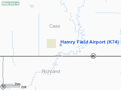
Location & QuickFacts
| FAA Information Effective: | 2008-09-25 |
| Airport Identifier: | K74 |
| Airport Status: | Operational |
| Longitude/Latitude: | 096-59-56.4346W/46-38-55.4307N
-96.999010/46.648731 (Estimated) |
| Elevation: | 947 ft / 288.65 m (Surveyed) |
| Land: | 40 acres |
| From nearest city: | 1 nautical miles E of Kindred, ND |
| Location: | Cass County, ND |
| Magnetic Variation: | 06E (1985) |
Owner & Manager
| Ownership: | Publicly owned |
| Owner: | City Of Kindred |
| Address: | P.o. Box 158
Kindred, ND 58051 |
| Phone number: | 701-428-3115 |
| Manager: | Robert Odegaard |
| Address: | 111 1st Ave N
Kindred, ND 58051 |
| Phone number: | 701-428-3457
CELL PHONE 701-730-2596 |
Airport Operations and Facilities
| Airport Use: | Open to public |
| Wind indicator: | Yes
OTS INDEFLY. |
| Segmented Circle: | No |
| Control Tower: | No |
| Lighting Schedule: | DUSK-DAWN |
| Landing fee charge: | No |
| Sectional chart: | Twin Cities |
| Region: | AGL - Great Lakes |
| Boundary ARTCC: | ZMP - Minneapolis |
| Tie-in FSS: | GFK - Grand Forks |
| FSS on Airport: | No |
| FSS Toll Free: | 1-800-WX-BRIEF |
| NOTAMs Facility: | GFK (NOTAM-d service avaliable) |
| Federal Agreements: | N |
Airport Communications
Airport Services
| Fuel available: | 100LL
SELF SERVICE FUEL AVBL 24 HRS WITH CREDIT CARD. |
| Airframe Repair: | MAJOR |
| Power Plant Repair: | MAJOR |
| Bottled Oxygen: | NONE |
| Bulk Oxygen: | NONE |
Runway Information
Runway 12/30
| Dimension: | 3300 x 60 ft / 1005.8 x 18.3 m |
| Surface: | CONC, Good Condition |
| Edge Lights: | Medium |
| |
Runway 12 |
Runway 30 |
| Longitude: | 097-00-17.2975W | 096-59-35.5717W |
| Latitude: | 46-39-03.1039N | 46-38-47.7574N |
| Elevation: | 947.00 ft | 944.00 ft |
| Traffic Pattern: | Left | Left |
| Markings: | Non-precision instrument, Good Condition | Non-precision instrument, Good Condition |
| Crossing Height: | 25.00 ft | 25.00 ft |
| VASI: | 2-light PAPI on left side | 2-light PAPI on left side |
| Visual Glide Angle: | 3.00° | 3.00° |
|
Radio Navigation Aids
| ID |
Type |
Name |
Ch |
Freq |
Var |
Dist |
| AA | NDB | Kenie | | 365.00 | 06E | 23.0 nm |
| BWP | NDB | Breckenridge-wahpeton | | 233.00 | 05E | 29.3 nm |
| GWR | NDB | Gwinner | | 278.00 | 07E | 37.0 nm |
| VCY | NDB | Valley City | | 382.00 | 07E | 40.1 nm |
| FFM | VOR/DME | Fergus Falls | 041X | 110.40 | 05E | 41.0 nm |
| DTL | VOR/DME | Detroit Lakes | 049X | 111.20 | 05E | 47.0 nm |
| FAR | VORTAC | Fargo | 109X | 116.20 | 09E | 8.8 nm |
Images and information placed above are from
http://www.airport-data.com/airport/K74/
We thank them for the data!
|
|


