|
|
| Grand Forks International Airport |
 |
| IATA: GFK – ICAO: KGFK – FAA LID: GFK |
| Summary |
| Airport type |
Public |
| Operator |
Grand Forks Regional Airport Authority |
| Location |
Grand Forks, North Dakota |
| Elevation AMSL |
845 ft / 258 m |
| Coordinates |
47°56′57″N 097°10′34″W / 47.94917°N 97.17611°W / 47.94917; -97.17611 (Grand Forks International Airport)Coordinates: 47°56′57″N 097°10′34″W / 47.94917°N 97.17611°W / 47.94917; -97.17611 (Grand Forks International Airport) |
| Website |
www.GFKairport.com |
| Runways |
| Direction |
Length |
Surface |
| ft |
m |
| 9L/27R |
4,206 |
1,282 |
Concrete |
| 17L/35R |
3,900 |
1,189 |
Concrete |
| 17R/35L |
7,349 |
2,240 |
Asphalt |
| 9R/27L |
3,300 |
1,006 |
Concrete |
| Statistics (2006) |
| Aircraft operations |
224,942 |
| Sources: FAA and airport web site |
Grand Forks International Airport (IATA: GFK, ICAO: KGFK, FAA LID: GFK) is a public airport located five miles (8 km) northwest of the central business district of Grand Forks, a city in Grand Forks County, North Dakota, United States. GFK has no scheduled passenger airline service out of the country but receives its international title (like many other airports) because it has customs service available for general aviation aircraft arriving from Canada and other countries.
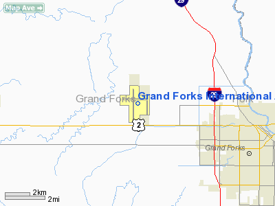
The airport, sometimes called Mark Andrews International Airport after Mark Andrews, a former U.S. House Representative and U.S. Senator from North Dakota, is owned by the Grand Forks Regional Airport Authority and located on U.S. Highway 2, around four miles (6 km) west of Interstate 29, within city limits in a detached section of the city that is surrounded by Rye Township.
In 2009, the airport's FAA control tower was the 23rd busiest in the nation, with a total of 346,165 tower operations. Approximately 90% of all airport operations at GFK are flights operated by the University of North Dakota's John D. Odegard School of Aerospace Sciences which is based on the field. Facilities
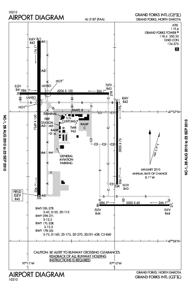
 | |
FAA diagram of GFK |
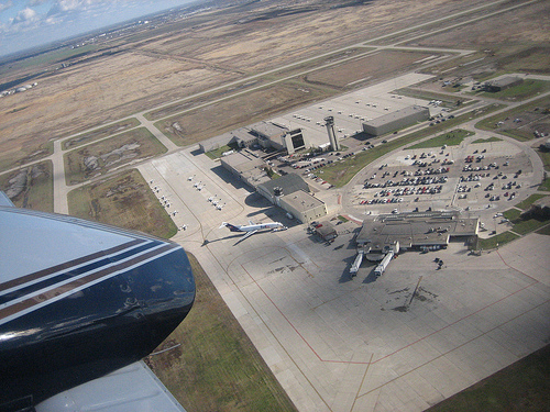
Terminal
The current passenger terminal at GFK was built in 1964. Outside terminal security are the Delta and Allegiant Airlines ticketing counters, a restaurant, a gift shop and a waiting area. After passing through security screening there is a small waiting area that serves the terminal's two passenger gates.
In the mid-2000s, discussion began of upgrading or totally replacing the terminal as it has structural and safety problems and leaves little to no room for expansion. Findings from a study commissioned by the Grand Forks Regional Airport Authority were released in early 2005. The study, which was done by Ulteig Engineers, gave the Airport Authority options for the future of the passenger terminal.
One option was to keep the terminal as is and not perform any upgrades. The consulting group did not recommend this as the terminal has too many structural and safety problems. The list of problems include: mold growth, roof leakage, differential settlement, blocking runway line of sight, passenger boarding, potential equipment damage from basement flooding, outdated electrical and mechanical systems, no sprinkler system, code deficiencies, insufficient parking setback, and interior traffic circulation issues. The terminal could be rehabilitated for $18.3 million, however, that would leave many issues unresolved and leave no room for expansion.
The consulting group recommended that a brand new passenger terminal would the best solution to the current terminal's problems. Five locations for a new terminal were evaluated favoring a site between the cargo apron and general aviation apron. Ground was broken on the new terminal in July 2009, with completion expected in 2011.
Runways
Grand Forks International Airport covers an area of 1,618 acres (655 ha) which contains four runways:
- Runway 9L/27R: 4,206 × 100 ft (1,282 × 30 m), Concrete
- Runway 17L/35R: 3,900 × 75 ft (1,189 × 23 m), Concrete
- Runway 17R/35L: 7,349 × 150 ft (2,240 × 46 m), Asphalt
- Runway 9R/27L: 3,300 × 60 ft (1,006 × 18 m), Concrete
Due to the increased amount of general aviation traffic, primarily from the UND Aerospace flight training school, a fourth runway has been completed. Located in the southeastern portion of the airport, it will operate as a parallel east/west runway and is named 9R/27L. The previous runway 8/26 was renamed in October 2008 to 9L/27R in preparation for the new runway.
Aircraft
For the 12-month period ending December 31st, 2008, the airport had 241,459 aircraft operations, an average of 662 per day: 93% air taxi, 5% general aviation, 1% scheduled commercial and 1% military.
GFK Flight Support
GFK Flight Support, the fixed base operator at the airport, began construction of a new $4.5 million dollar facility in September 2007. Completed in Fall 2008, this 45,000 sq ft (4,200 m) facility increased GFK Flight Support's heated hangar and aircraft support space to 130,000 sq ft (12,000 m) making it the largest aircraft service center in North Dakota. The previous facilities are now used by wing of the U.S. Customs and Border Protection, housing a number of government aircraft and helicopters.
Airlines and destinations
| Airlines |
Destinations |
| Allegiant Air |
Las Vegas, Phoenix/Mesa |
| Delta Air Lines |
Minneapolis/St. Paul |
| Delta Connection operated by Mesaba Airlines |
Minneapolis/St. Paul |
| Delta Connection operated by Pinnacle Airlines |
Minneapolis/St. Paul |
Cargo
| Airlines |
Destinations |
| FedEx Express |
Memphis, Minneapolis/St. Paul, Sioux Falls, Winnipeg |
| FedEx Feeder operated by Corporate Air |
Minot, Bismarck, Dickinson, Williston, ND. Thief River Falls, Bemidji, MN |
The above content comes from Wikipedia and is published under free licenses – click here to read more.
Location & QuickFacts
| FAA Information Effective: | 2008-09-25 |
| Airport Identifier: | GFK |
| Airport Status: | Operational |
| Longitude/Latitude: | 097-10-34.0000W/47-56-57.3000N
-97.176111/47.949250 (Estimated) |
| Elevation: | 845 ft / 257.56 m (Surveyed) |
| Land: | 1618 acres |
| From nearest city: | 5 nautical miles NW of Grand Forks, ND |
| Location: | Grand Forks County, ND |
| Magnetic Variation: | 06E (1985) |
Owner & Manager
| Ownership: | Publicly owned |
| Owner: | Grand Forks Reg Arpt Auth |
| Address: | 2787 Airport Drive
Grand Forks, ND 58203 |
| Phone number: | 701-795-6981 |
| Manager: | Steve Johnson |
| Address: | 2787 Airport Dr
Grand Forks, ND 58203 |
| Phone number: | 701-795-6981 |
Airport Operations and Facilities
| Airport Use: | Open to public |
| Wind indicator: | Yes |
| Segmented Circle: | No |
| Control Tower: | Yes |
| Lighting Schedule: | DUSK-DAWN
ACTVT REIL RY 26 & RY 17R - CTAF. WHEN TWR CLSD ACTVT HIRL RY 17R/35L & MALSR RY 35L; MIRL RY 08/26 - CTAF. MIRL RY 17L/35R PRESET ON LOW INTST 2330-0200. PAPI RY 35L OPER CONTINOUSLY. |
| Beacon Color: | Clear-Green (lighted land airport) |
| Landing fee charge: | No |
| Sectional chart: | Twin Cities |
| Region: | AGL - Great Lakes |
| Boundary ARTCC: | ZMP - Minneapolis |
| Tie-in FSS: | GFK - Grand Forks
CTC GRAND FORKS RADIO FOR AIRPORT ADVISORY SERVICE ON 118.4 WHEN TOWER IS CLSD. |
| FSS on Airport: | No |
| FSS Toll Free: | 1-800-WX-BRIEF |
| NOTAMs Facility: | GFK (NOTAM-d service avaliable) |
| Certification type/date: | I B S 05/1973
ARFF INDEX B SVC AVBL 0500-2400; OTHER TIMES PPR FOR ACR OPNS WITH MORE THAN 30 PASSENGER SEATS. CALL AMGR ON 701-795-6984. |
| Federal Agreements: | NGY |
Airport Communications
| CTAF: | 118.400 |
| Unicom: | 122.950 |
Airport Services
| Fuel available: | 100LLA |
| Airframe Repair: | MAJOR |
| Power Plant Repair: | MAJOR |
| Bottled Oxygen: | HIGH |
Runway Information
Runway 08/26
| Dimension: | 4206 x 100 ft / 1282.0 x 30.5 m |
| Surface: | CONC, Good Condition |
| Weight Limit: | Single wheel: 43000 lbs.
Dual wheel: 55000 lbs.
Dual tandem wheel: 115000 lbs. |
| Edge Lights: | Medium |
| |
Runway 08 |
Runway 26 |
| Longitude: | 097-11-05.7204W | 097-10-03.9405W |
| Latitude: | 47-57-08.6100N | 47-57-08.6056N |
| Elevation: | 841.00 ft | 843.00 ft |
| Alignment: | 90 | 127 |
| Traffic Pattern: | Left | Right |
| Markings: | Basic, Good Condition | Basic, Fair Condition |
| Crossing Height: | 39.00 ft | 45.00 ft |
| VASI: | 4-box on left side | 4-box on left side |
| Visual Glide Angle: | 3.00° | 3.00° |
| Runway End Identifier: | | Yes |
|
Runway 17L/35R
| Dimension: | 3901 x 75 ft / 1189.0 x 22.9 m |
| Surface: | CONC, Fair Condition |
| Weight Limit: | Single wheel: 12500 lbs. |
| Edge Lights: | Medium |
| |
Runway 17L |
Runway 35R |
| Longitude: | 097-09-58.3640W | 097-09-58.4052W |
| Latitude: | 47-57-04.8560N | 47-56-26.3638N |
| Elevation: | 842.00 ft | 843.00 ft |
| Alignment: | 127 | 0 |
| Traffic Pattern: | Left | Right |
| Markings: | Basic, Good Condition | Basic, Good Condition |
| Crossing Height: | 21.00 ft | 21.00 ft |
| VASI: | 4-light PAPI on left side | 4-light PAPI on left side |
| Visual Glide Angle: | 3.00° | 3.00° |
|
Runway 17R/35L
| Dimension: | 7351 x 150 ft / 2240.6 x 45.7 m |
| Surface: | ASPH, Fair Condition |
| Surface Treatment: | Saw-cut or plastic Grooved |
| Weight Limit: | Single wheel: 75000 lbs.
Dual wheel: 160000 lbs.
Dual tandem wheel: 270000 lbs. |
| Edge Lights: | High |
| |
Runway 17R |
Runway 35L |
| Longitude: | 097-10-52.4134W | 097-10-52.4588W |
| Latitude: | 47-57-33.2829N | 47-56-20.7435N |
| Elevation: | 843.00 ft | 844.00 ft |
| Alignment: | 127 | 0 |
| ILS Type: | | ILS/DME
|
| Traffic Pattern: | Right | Left |
| Markings: | Precision instrument, Good Condition | Precision instrument, Fair Condition |
| Crossing Height: | 48.00 ft | 61.00 ft |
| VASI: | 4-box on left side | 4-light PAPI on left side |
| Visual Glide Angle: | 3.00° | 2.76° |
| Approach lights: | | MALSR |
| Runway End Identifier: | Yes | |
|
Radio Navigation Aids
| ID |
Type |
Name |
Ch |
Freq |
Var |
Dist |
| CKN | NDB | Crookston | | 400.00 | 07E | 23.5 nm |
| RDR | TACAN | Red River | 111X | | 06E | 9.3 nm |
| GFK | VOR/DME | Grand Forks | 090X | 114.30 | 09E | 0.5 nm |
| TVF | VOR/DME | Thief River Falls | 021X | 108.40 | 08E | 40.4 nm |
Remarks
- HVY STUDENT TRNG ACTVTY WI 15 MI OF ARPT.
- TWY A4 BTN TWY A & A APRON, TWY G & TWY U CLSD TO FIXED WING ACFT 12,500 LBS & OVER.
- WESTERN MOST 100 FT OF TWY C1 IS AN EXTENSION OF THE BRAVO APRON & NOT VSBL FR THE TWR.
- CURRENT AIRFIELD CONDITIONS MAY BE OBTAINED VIA THE AIRPORT.
- BIRDS ON & INVOF ARPT.
- CTC GRAND FORKS AFSS FOR SFC CONDITIONS.
- LGTD ENTRANCE RD 1600' EAST OF RY 17R/35L.
- CUSTOMS AVBL 1300-2100 MON-FRI; OTHER TIMES ON REQ 701-772-3301.
- PAEW 2330-0600.
- HVY STUDENT HELICOPTER TRAINING AT ARPT BTN PARALLEL TWYS.-
Images and information placed above are from
http://www.airport-data.com/airport/GFK/
We thank them for the data!
| General Info
|
| Country |
United States
|
| State |
NORTH DAKOTA
|
| FAA ID |
GFK
|
| Latitude |
47-56-57.318N
|
| Longitude |
097-10-34.000W
|
| Elevation |
845 feet
|
| Near City |
GRAND FORKS
|
We don't guarantee the information is fresh and accurate. The data may
be wrong or outdated.
For more up-to-date information please refer to other sources.
|
|