 |
|
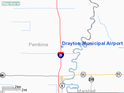
Location & QuickFacts
| FAA Information Effective: | 2008-09-25 |
| Airport Identifier: | D29 |
| Airport Status: | Operational |
| Longitude/Latitude: | 097-10-37.3000W/48-37-06.7250N
-97.177028/48.618535 (Estimated) |
| Elevation: | 798 ft / 243.23 m (Estimated) |
| Land: | 23 acres |
| From nearest city: | 3 nautical miles N of Drayton, ND |
| Location: | Walsh County, ND |
| Magnetic Variation: | 07E (1985) |
Owner & Manager
| Ownership: | Publicly owned |
| Owner: | Drayton Airport Authority |
| Address: | Po Box 280
Drayton, ND 58225 |
| Phone number: | 701-454-3590 |
| Manager: | Drayton Arpt Auth
LOCAL CONTACT ROBB BOLL 701-454-3317/6103 OR CITY HALL 454-3590 |
| Address: | Box 280
Drayton, ND 58225 |
| Phone number: | 701-454-3590 |
Airport Operations and Facilities
| Airport Use: | Open to public |
| Wind indicator: | Yes |
| Segmented Circle: | No |
| Control Tower: | No |
| Lighting Schedule: | DUSK-DAWN
LIRL RY 17/35 OPER DUSK-2400; AFTER 2400 HR ACTVT LIRL RWY 17/35-CTAF |
| Beacon Color: | Clear-Green (lighted land airport)
ROTG BCN OTS INDEFLY. |
| Landing fee charge: | No |
| Sectional chart: | Twin Cities |
| Region: | AGL - Great Lakes |
| Boundary ARTCC: | ZMP - Minneapolis |
| Tie-in FSS: | GFK - Grand Forks |
| FSS on Airport: | No |
| FSS Toll Free: | 1-800-WX-BRIEF |
| NOTAMs Facility: | GFK (NOTAM-d service avaliable) |
Airport Communications
Airport Services
Runway Information
Runway 17/35
| Dimension: | 2600 x 60 ft / 792.5 x 18.3 m |
| Surface: | ASPH, Poor Condition
RWY 17/35 SFC UNEVEN & RUTTED. |
| Surface Treatment: | Aggregate Friction Seal Coat |
| Weight Limit: | Single wheel: 4000 lbs. |
| Edge Lights: | Low |
| |
Runway 17 |
Runway 35 |
| Longitude: | 097-10-37.3000W | 097-10-37.3000W |
| Latitude: | 48-37-19.5500N | 48-36-53.9000N |
| Elevation: | 798.00 ft | 798.00 ft |
| Traffic Pattern: | Left | Left |
| Markings: | Basic, | Basic, Good Condition |
| Displaced threshold: | 0.00 ft | 320.00 ft
DSPLCD THR - NGT OPNS ONLY. |
|
Radio Navigation Aids
| ID |
Type |
Name |
Ch |
Freq |
Var |
Dist |
| RDR | TACAN | Red River | 111X | | 06E | 40.8 nm |
| GFK | VOR/DME | Grand Forks | 090X | 114.30 | 09E | 39.9 nm |
| HML | VORTAC | Humboldt | 071X | 112.40 | 09E | 15.3 nm |
Remarks
- SNOW REMOVAL IREG.CFM WINTER CONDS BEFORE USE CALL (701) 454-3590.
Images and information placed above are from
http://www.airport-data.com/airport/D29/
We thank them for the data!
| General Info
|
| Country |
United States
|
| State |
NORTH DAKOTA
|
| FAA ID |
D29
|
| Latitude |
48-37-06.945N
|
| Longitude |
097-10-33.253W
|
| Elevation |
798 feet
|
| Near City |
DRAYTON
|
We don't guarantee the information is fresh and accurate. The data may
be wrong or outdated.
For more up-to-date information please refer to other sources.
|
|


