 |
|
Coordinates: 48°06′52″N 098°54′31″W / 48.11444°N 98.90861°W / 48.11444; -98.90861
Devils Lake Regional Airport
Knoke Field |
 |
| IATA: DVL – ICAO: KDVL – FAA LID: DVL |
| Summary |
| Airport type |
Public |
| Operator |
Devils Lake Airport Authority |
| Location |
Devils Lake, North Dakota |
| Elevation AMSL |
1,455 ft / 444 m |
| Runways |
| Direction |
Length |
Surface |
| ft |
m |
| 13/31 |
5,509 |
1,679 |
Asphalt |
| 3/21 |
4,313 |
1,315 |
Asphalt |
| Statistics (2006) |
| Aircraft operations |
23,342 |
| Passenger boardings |
3,347 |
| Sources: FAA and airport web site |
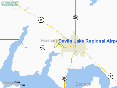
Former airport logo Devils Lake Regional Airport (IATA: DVL, ICAO: KDVL, FAA LID: DVL), also known as Knoke Field, is a public airport located two miles (3 km) west of the central business district of Devils Lake, a city in Ramsey County, North Dakota, United States. It is owned by the Devils Lake Airport Authority and was formerly known as Devils Lake Municipal Airport.
A new terminal recently opened for business at the airport. DVL is mostly used for general aviation but is also served by one commercial airline, with flights twice each weekday and once on Saturdays and Sundays. Service is subsidized by the Essential Air Service program. Facilities and aircraft
Devils Lake Regional Airport covers an area of 647 acres (262 ha) which contains two asphalt paved runways: 13/31 measuring 5,507 x 150 ft (1,679 x 46 m) and 3/21 measuring 4,311 x 75 ft (1,314 x 23 m). For the 12-month period ending November 30, 2006, the airport had 23,342 aircraft operations, an average of 63 per day: 86% general aviation, 10% air taxi and 4% military.
Airlines and destinations
| Airlines |
Destinations |
| Delta Connection operated by Mesaba Airlines |
Jamestown, Minneapolis/St. Paul |
The above content comes from Wikipedia and is published under free licenses – click here to read more.
Location & QuickFacts
| FAA Information Effective: | 2008-09-25 |
| Airport Identifier: | DVL |
| Airport Status: | Operational |
| Longitude/Latitude: | 098-54-31.3000W/48-06-51.5000N
-98.908694/48.114306 (Estimated) |
| Elevation: | 1456 ft / 443.79 m (Surveyed) |
| Land: | 647 acres |
| From nearest city: | 2 nautical miles W of Devils Lake, ND |
| Location: | Ramsey County, ND |
| Magnetic Variation: | 07E (2000) |
Owner & Manager
| Ownership: | Publicly owned |
| Owner: | Devils Lake Airport Authority
JAMES KIENAST CHAIRMAN |
| Address: | 106 National Guard St Nw
Devils Lake, ND 58301-8993 |
| Phone number: | 701-662-5833 |
| Manager: | Patricia A. Traynor |
| Address: | 106 National Guard St Nw
Devils Lake, ND 58301-8993 |
| Phone number: | 701-662-5833 |
Airport Operations and Facilities
| Airport Use: | Open to public |
| Wind indicator: | Yes |
| Segmented Circle: | Yes |
| Control Tower: | No |
| Lighting Schedule: | DUSK-DAWN
HIRL RY 13/31 PRESET ON LOW INTST DUSK-DAWN; TO INCR INTST & ACTVT MIRL RY 03/21; REIL RY 03/21 - CTAF. |
| Beacon Color: | Clear-Green (lighted land airport) |
| Landing fee charge: | No |
| Sectional chart: | Twin Cities |
| Region: | AGL - Great Lakes |
| Boundary ARTCC: | ZMP - Minneapolis |
| Tie-in FSS: | GFK - Grand Forks |
| FSS on Airport: | No |
| FSS Toll Free: | 1-800-WX-BRIEF |
| NOTAMs Facility: | DVL (NOTAM-d service avaliable) |
| Certification type/date: | I A S 01/2004
48 HRS PPR FOR UNSKED ACR OPS W/ MORE THAN 30 PSGRS CALL AMGR 701-662-5833. RY 03/21 CLSD TO ACR ACFT W/ MORE THAN 9 PSGR SEATS. |
| Federal Agreements: | NGY3 |
Airport Communications
| CTAF: | 122.800 |
| Unicom: | 122.800 |
Airport Services
| Fuel available: | 100LLA
JET 'A' FUEL AVBL; CALL 701-662-3221; IREG HRS. |
| Airframe Repair: | MAJOR |
| Power Plant Repair: | MAJOR |
| Bottled Oxygen: | NONE |
| Bulk Oxygen: | NONE |
Runway Information
Runway 03/21
| Dimension: | 4311 x 75 ft / 1314.0 x 22.9 m |
| Surface: | ASPH, Fair Condition |
| Weight Limit: | Single wheel: 12500 lbs. |
| Edge Lights: | Medium |
| |
Runway 03 |
Runway 21 |
| Longitude: | 098-55-00.5973W | 098-54-15.6387W |
| Latitude: | 48-06-34.1857N | 48-07-04.2370N |
| Elevation: | 1450.00 ft | 1442.00 ft |
| Alignment: | 45 | 127 |
| Traffic Pattern: | Left | Left |
| Markings: | Basic, Poor Condition
RUNWAY MARKINGS ARE FADED | Basic, Poor Condition
RUNWAY MARKINGS ARE FADED |
| Crossing Height: | 25.00 ft | 25.00 ft |
| Displaced threshold: | 173.00 ft | 0.00 ft |
| VASI: | 2-light PAPI on left side | 2-light PAPI on left side |
| Visual Glide Angle: | 3.00° | 3.00° |
| Runway End Identifier: | Yes | Yes |
| Obstruction: | 26 ft road, 555.0 ft from runway, 290 ft left of centerline, 13:1 slope to clear
RWY 03 APCH RATIO 28:1 AT DSPLCD THLD. | , 50:1 slope to clear |
|
Runway 13/31
| Dimension: | 5507 x 150 ft / 1678.5 x 45.7 m |
| Surface: | ASPH, Fair Condition |
| Surface Treatment: | Porous Friction Course |
| Weight Limit: | Single wheel: 75000 lbs.
Dual wheel: 130000 lbs.
Dual tandem wheel: 190000 lbs. |
| Edge Lights: | High |
| |
Runway 13 |
Runway 31 |
| Longitude: | 098-54-53.1503W | 098-53-58.9272W |
| Latitude: | 48-07-13.4827N | 48-06-33.0586N |
| Elevation: | 1456.00 ft | 1444.00 ft |
| Alignment: | 127 | 127 |
| ILS Type: | | ILS
|
| Traffic Pattern: | Left | Left |
| Markings: | Non-precision instrument, Fair Condition | Precision instrument, Fair Condition |
| Crossing Height: | 52.00 ft | 42.00 ft |
| Displaced threshold: | 0.00 ft | 641.00 ft |
| VASI: | 4-box on left side | 4-box on left side |
| Visual Glide Angle: | 3.00° | 3.00° |
| Approach lights: | | MALSR |
| Runway End Identifier: | Yes | |
| Obstruction: | 15 ft road, 468.0 ft from runway, 518 ft left of centerline, 17:1 slope to clear | 16 ft road, 248.0 ft from runway, 503 ft left of centerline, 3:1 slope to clear
APCH RATIO 50:1 AT DSPLCD THR. |
|
Radio Navigation Aids
| ID |
Type |
Name |
Ch |
Freq |
Var |
Dist |
| RUG | NDB | Rugby | | 212.00 | 08E | 47.7 nm |
| DVL | VOR/DME | Devils Lake | 047X | 111.00 | 07E | 0.2 nm |
Remarks
- NUMEROUS WATERFOWL & OTHER BIRDS; DEER & JACK RABBITS ON & INVOF ARPT.
Images and information placed above are from
http://www.airport-data.com/airport/DVL/
We thank them for the data!
| General Info
|
| Country |
United States
|
| State |
NORTH DAKOTA
|
| FAA ID |
DVL
|
| Latitude |
48-06-51.283N
|
| Longitude |
098-54-31.602W
|
| Elevation |
1455 feet
|
| Near City |
DEVILS LAKE
|
We don't guarantee the information is fresh and accurate. The data may
be wrong or outdated.
For more up-to-date information please refer to other sources.
|
|


