 |
|
Coordinates: 46°11′13″N 103°25′41″W / 46.18694°N 103.42806°W / 46.18694; -103.42806
| Bowman Municipal Airport |
| IATA: BWM – ICAO: KBPP – FAA LID: BPP |
| Summary |
| Airport type |
Public |
| Operator |
Bowman County Airport Authority |
| Serves |
Bowman, North Dakota |
| Elevation AMSL |
2,958 ft / 902 m |
| Runways |
| Direction |
Length |
Surface |
| ft |
m |
| 11/29 |
4,800 |
1,463 |
Asphalt |
| Statistics (2007) |
| Aircraft operations |
3,620 |
| Source: Federal Aviation Administration |
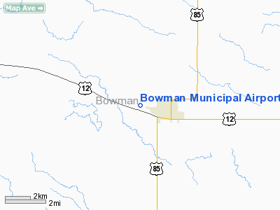
Bowman Municipal Airport (IATA: BWM, ICAO: KBPP, FAA LID: BPP) is a public airport located two miles (3 km) west of the central business district of Bowman, a city in Bowman County, North Dakota, United States. It is owned by the Bowman County Airport Authority.
Although most U.S. airports use the same three-letter location identifier for the FAA and IATA, Bowman Municipal Airport is assigned BPP by the FAA and BWM by the IATA.
Facilities and aircraft
Bowman Municipal Airport covers an area of 160 acres (65 ha) which contains one runway designated 11/29 with a 4,800 x 75 ft (1,463 x 23 m) asphalt surface. For the 12-month period ending July 31, 2007, the airport had 3,620 aircraft operations: 88% general aviation, 11% air taxi, and 1% military.
The above content comes from Wikipedia and is published under free licenses – click here to read more.
Location & QuickFacts
| FAA Information Effective: | 2008-09-25 |
| Airport Identifier: | BPP |
| Airport Status: | Operational |
| Longitude/Latitude: | 103-25-41.0900W/46-11-13.1680N
-103.428081/46.186991 (Estimated) |
| Elevation: | 2958 ft / 901.60 m (Surveyed) |
| Land: | 160 acres |
| From nearest city: | 2 nautical miles W of Bowman, ND |
| Location: | Bowman County, ND |
| Magnetic Variation: | 10E (2000) |
Owner & Manager
| Ownership: | Publicly owned |
| Owner: | Bowman County Arpt Auth
WILLIAM FISCHER PRES, BOW CO ARPT AUTH, PHONE 701-275-8878. |
| Address: | Po Box 331
Bowman, ND 58623 |
| Phone number: | 701-523-5696
APT AUTH MEMBER BOB MORLAND |
| Manager: | Max Arnett
ADDL CTC; STANLEY POPE (701) 523-3755/ 6866 |
| Address: | Box 198
Bowman, ND 58623 |
| Phone number: | 701-523-5504
MGR HOME PHONE 701-523-3544 / 6889 CELL |
Airport Operations and Facilities
| Airport Use: | Open to public |
| Wind indicator: | Yes |
| Segmented Circle: | Yes |
| Control Tower: | No |
| Lighting Schedule: | DUSK-DAWN
VASI RYS 11 & 29 OPER DUSK-1800. MIRL RY 11/29 PRESET ON LOW INTST DUSK-1800; TO INCR INTST - CTAF. AFT 1800 ACTVT MIRL RY 11/29 AND VASI RYS 11 & 29 - CTAF. |
| Beacon Color: | Clear-Green (lighted land airport) |
| Landing fee charge: | No |
| Sectional chart: | Billings |
| Region: | AGL - Great Lakes |
| Boundary ARTCC: | ZLC - Salt Lake City |
| Tie-in FSS: | GFK - Grand Forks |
| FSS on Airport: | No |
| FSS Toll Free: | 1-800-WX-BRIEF |
| NOTAMs Facility: | BPP (NOTAM-d service avaliable) |
| Federal Agreements: | NGY |
Airport Communications
| CTAF: | 122.800 |
| Unicom: | 122.800 |
Airport Services
| Fuel available: | 100 A
FOR FUEL AFT HRS CALL 701-523-5504/3544/6889. |
| Airframe Repair: | MAJOR |
| Power Plant Repair: | MAJOR |
Runway Information
Runway 11/29
| Dimension: | 4800 x 75 ft / 1463.0 x 22.9 m |
| Surface: | ASPH, Good Condition |
| Weight Limit: | Single wheel: 12500 lbs. |
| Edge Lights: | Medium |
| |
Runway 11 |
Runway 29 |
| Longitude: | 103-26-08.9930W | 103-25-13.1910W |
| Latitude: | 46-11-26.7920N | 46-10-59.5410N |
| Elevation: | 2954.00 ft | 2956.00 ft |
| Alignment: | 125 | 127 |
| Traffic Pattern: | Right | Left |
| Markings: | Non-precision instrument, Good Condition | Non-precision instrument, Good Condition |
| Crossing Height: | 25.00 ft | 25.00 ft |
| VASI: | 2-box on left side | 2-box on left side |
| Visual Glide Angle: | 3.00° | 3.00° |
| Runway End Identifier: | No | No |
| Centerline Lights: | No | No |
| Touchdown Lights: | No | No |
| Obstruction: | 21 ft rr, 300.0 ft from runway, 260 ft left of centerline, 4:1 slope to clear
RWY 11APCH SLOPE 20:1 TO DSPLCD THR | 40 ft tree, 1356.0 ft from runway, 100 ft right of centerline, 28:1 slope to clear |
|
Radio Navigation Aids
| ID |
Type |
Name |
Ch |
Freq |
Var |
Dist |
| BOD | NDB | Bowman | | 374.00 | 10E | 0.1 nm |
| HEI | NDB | Hettinger | | 392.00 | 12E | 34.0 nm |
| BKU | NDB | Timber | | 344.00 | 12E | 35.7 nm |
| BUA | VOR/DME | Buffalo | 031X | 109.40 | 13E | 38.2 nm |
| DIK | VORTAC | Dickinson | 076X | 112.90 | 14E | 48.7 nm |
Remarks
- PVT AIRFLD 9200'FM RWY 29 THR ON SE DRCTN FM ARPT.
- +80'HILL 700'FM THR 1400'R OF EXTDD CL.
- +156'HILL 7500'FM THR 600'L OF EXTDD CL.
- PARALLEL TWY UNLGTD BUT MARKED WITH REFLECTORIZED TWY MARKERS.
- CONFIRM SNOW REMOVAL WITH MGR AFT MAJOR STORM
- +562 FT TWR ON HILL 10750 FT NE OF ARPT.
- CONC FUEL PAD FOR HEAVY TWIN ACFT PARKING AVBL.
Images and information placed above are from
http://www.airport-data.com/airport/BPP/
We thank them for the data!
| General Info
|
| Country |
United States
|
| State |
NORTH DAKOTA
|
| FAA ID |
BPP
|
| Latitude |
46-11-13.168N
|
| Longitude |
103-25-41.090W
|
| Elevation |
2958 feet
|
| Near City |
BOWMAN
|
We don't guarantee the information is fresh and accurate. The data may
be wrong or outdated.
For more up-to-date information please refer to other sources.
|
|


