 |
|
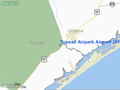
Location & QuickFacts
| FAA Information Effective: | 2008-09-25 |
| Airport Identifier: | 01NC |
| Airport Status: | Operational |
| Longitude/Latitude: | 077-34-53.0000W/34-28-31.0000N
-77.581389/34.475278 (Estimated) |
| Elevation: | 65 ft / 19.81 m (Estimated) |
| Land: | 100 acres |
| From nearest city: | 2 nautical miles SW of Holly Ridge, NC |
| Location: | Pender County, NC |
| Magnetic Variation: | 08W (1990) |
Owner & Manager
| Ownership: | Privately owned |
| Owner: | John F. Young |
| Address: | 25311 Hwy 17 N
Hampstead, NC 28443-2558 |
| Phone number: | 910-329-1866 |
| Manager: | John F. Young |
| Address: | 108 Inlet Court
Hampstead, NC 28443-2558 |
| Phone number: | 910-270-2607 |
Airport Operations and Facilities
| Airport Use: | Private |
| Wind indicator: | Yes |
| Segmented Circle: | No |
| Control Tower: | No |
| Lighting Schedule: | RDO-CTL
ACTVT RY LGTS RY 03/21THREE CLICKS ON FREQ 122.9. |
| Sectional chart: | Charlotte |
| Region: | ASO - Southern |
| Boundary ARTCC: | ZDC - Washington |
| Tie-in FSS: | RDU - Raleigh |
| FSS on Airport: | No |
| FSS Toll Free: | 1-800-WX-BRIEF |
Runway Information
Runway 03/21
| Dimension: | 3200 x 75 ft / 975.4 x 22.9 m |
| Surface: | TURF,
15 FT CENTER IS ASPH. |
| Edge Lights: | Non-standard lighting system
NON-STD LIRL, NON FAA APPROVED. |
| |
Runway 03 |
Runway 21 |
| Traffic Pattern: | Left | Left |
|
Runway 18/36
| Dimension: | 2000 x 75 ft / 609.6 x 22.9 m |
| Surface: | ASPH-TURF,
15 FT CENTER IS ASPH. |
| |
Runway 18 |
Runway 36 |
| Traffic Pattern: | Left | Right |
|
Radio Navigation Aids
| ID |
Type |
Name |
Ch |
Freq |
Var |
Dist |
| NCA | NDB | New River | | 356.00 | 08W | 16.6 nm |
| ACZ | NDB | Pendy | | 379.00 | 09W | 25.4 nm |
| CLB | NDB | Carolina Beach | | 216.00 | 04W | 29.1 nm |
| DKA | NDB | Kenan | | 332.00 | 07W | 39.6 nm |
| SUT | NDB | Yaupon | | 233.00 | 08W | 41.0 nm |
| TGQ | NDB | Elizabethtown | | 398.00 | 08W | 46.4 nm |
| MRH | NDB | Morehead | | 269.00 | 08W | 48.0 nm |
| CTZ | NDB | Clinton | | 412.00 | 08W | 48.9 nm |
| DIW | NDB/DME | Dixon | 107X | 198.00 | 08W | 8.5 nm |
| NCA | TACAN | New River | 101X | | 08W | 15.6 nm |
| NJM | TACAN | Bogue Mcalf | 067X | | 08W | 30.2 nm |
| NKT | TACAN | Cherry Point | 075X | | 09W | 43.3 nm |
| EWN | VOR/DME | New Bern | 083X | 113.60 | 08W | 44.6 nm |
| ILM | VORTAC | Wilmington | 117X | 117.00 | 07W | 16.3 nm |
Remarks
- PROVIDED ALL OPS ARE CONDUCTED IN VFR WX COND. ALL TFC PATTERNS MUST REMAIN WEST OF THE EXTENDED CNTRLN OF RY 18/36. LNDG AREA IS LIMITED TO PR USE ONLY.
Images and information placed above are from
http://www.airport-data.com/airport/01NC/
We thank them for the data!
| General Info
|
| Country |
United States
|
| State |
NORTH CAROLINA
|
| FAA ID |
01NC
|
| Latitude |
34-28-31.000N
|
| Longitude |
077-34-53.000W
|
| Elevation |
65 feet
|
| Near City |
HOLLY RIDGE
|
We don't guarantee the information is fresh and accurate. The data may
be wrong or outdated.
For more up-to-date information please refer to other sources.
|
|


