 |
|
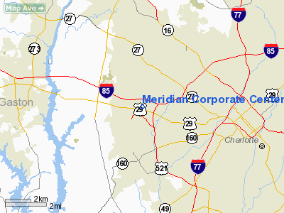
Meridian Corporate Center Heliport |
Location & QuickFacts
| FAA Information Effective: | 2008-09-25 |
| Airport Identifier: | 2NC5 |
| Airport Status: | Operational |
| Longitude/Latitude: | 080-55-59.2620W/35-14-10.5080N
-80.933128/35.236252 (Estimated) |
| Elevation: | 773 ft / 235.61 m (Estimated) |
| Land: | 0 acres |
| From nearest city: | 0 nautical miles N of Charlotte, NC |
| Location: | Mecklenburg County, NC |
| Magnetic Variation: | 05W (1985) |
Owner & Manager
| Ownership: | Privately owned |
| Owner: | Charlotte Corporate Ctr Acq Llc |
| Address: | 8335 Ibm Drive Suite 101
Charlotte, NC 28262 |
| Phone number: | 704-547-0079 |
| Manager: | Jay Coombs Dir Of Opns |
| Address: | 8201 Ibm Drive
Charlotte, NC 28262 |
| Phone number: | 980-722-8674 |
Airport Operations and Facilities
| Airport Use: | Private |
| Wind indicator: | Yes |
| Segmented Circle: | No |
| Control Tower: | No |
| Sectional chart: | Atlanta |
| Region: | ASO - Southern |
| Boundary ARTCC: | ZTL - Atlanta |
| Tie-in FSS: | RDU - Raleigh |
| FSS Toll Free: | 1-800-WX-BRIEF |
Runway Information
Helipad H1
| Dimension: | 110 x 110 ft / 33.5 x 33.5 m |
| Surface: | ASPH, Good Condition |
| |
Runway H1 |
Runway |
| Traffic Pattern: | Left | Left |
|
Radio Navigation Aids
| ID |
Type |
Name |
Ch |
Freq |
Var |
Dist |
| MRN | FAN MARKER | Lenoir | | | 03W | 47.7 nm |
| GHJ | NDB | Stonia | | 260.00 | 06W | 11.3 nm |
| IZN | NDB | Lincolnton | | 432.00 | 06W | 19.6 nm |
| TWL | NDB | Wesley | | 204.00 | 06W | 20.4 nm |
| UZ | NDB | Rally | | 227.00 | 05W | 22.0 nm |
| DCM | NDB | Chester | | 220.00 | 06W | 30.1 nm |
| LKR | NDB | Lancaster | | 400.00 | 07W | 31.0 nm |
| SLP | NDB | First River | | 417.00 | 06W | 32.7 nm |
| VW | NDB | Temky | | 280.00 | 05W | 33.0 nm |
| RU | NDB | Rovdy | | 275.00 | 06W | 36.9 nm |
| HK | NDB | Tawba | | 332.00 | 06W | 37.8 nm |
| PYG | NDB | Pageland | | 270.00 | 06W | 41.6 nm |
| AFP | NDB | Anson County | | 283.00 | 07W | 43.7 nm |
| VU | NDB | Aller | | 346.00 | 06W | 44.5 nm |
| SEN | NDB | Swearing/dcmsnd | | 260.00 | 06W | 45.1 nm |
| FIQ | NDB | Fiddlers | | 391.00 | 07W | 46.0 nm |
| DVZ | NDB | Davie | | 354.00 | 06W | 46.9 nm |
| UOT | NDB | Union County | | 326.00 | 04W | 48.2 nm |
| CLT | VOR/DME | Charlotte | 097X | 115.00 | 05W | 2.9 nm |
| BZM | VOR/DME | Barretts Mountain | 045X | 110.80 | 06W | 40.9 nm |
| CTF | VOR/DME | Chesterfield | 019X | 108.20 | 03W | 47.9 nm |
| FML | VORTAC | Fort Mill | 071X | 112.40 | 02W | 14.9 nm |
| CLT | VOT | Charlotte | | 112.00 | | 1.3 nm |
| HKY | VOT | Hickory Regional | | 110.00 | | 37.7 nm |
Remarks
- ALL OPNS ARE CONDUCTED IN VFR WX CONDS. LNDG AREA LIMITED TO PR USE. OPNL LTR OF AGRMT ESTABD WITH CHARLOTTE ARPT ATCT AIR TFC MGR 704-399-1041. CHARLOTTE GADO BE CONTACTED TO SET UP INGRESS/EGRESS POINTS 704-392-3214.
Images and information placed above are from
http://www.airport-data.com/airport/2NC5/
We thank them for the data!
| General Info
|
| Country |
United States
|
| State |
NORTH CAROLINA
|
| FAA ID |
2NC5
|
| Latitude |
35-14-10.508N
|
| Longitude |
080-55-59.262W
|
| Elevation |
773 feet
|
| Near City |
CHARLOTTE
|
We don't guarantee the information is fresh and accurate. The data may
be wrong or outdated.
For more up-to-date information please refer to other sources.
|
|


