|
|
 |
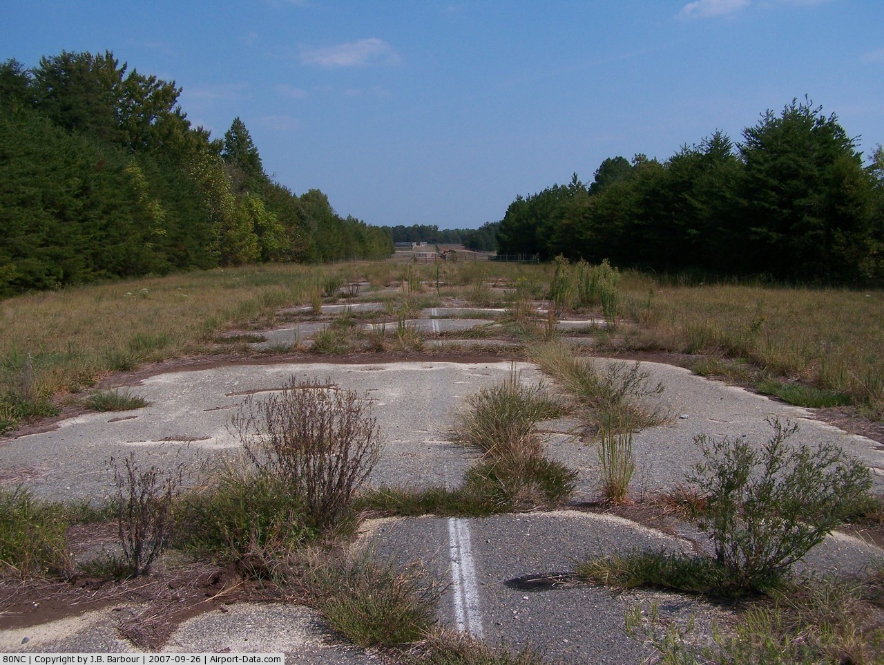
(Click on the photo to enlarge) |
Location & QuickFacts
| FAA Information Effective: | 2008-09-25 |
| Airport Identifier: | 80NC |
| Airport Status: | Operational |
| Longitude/Latitude: | 079-41-21.3950W/35-59-56.2870N
-79.689276/35.998969 (Estimated) |
| Elevation: | 777 ft / 236.83 m (Surveyed) |
| Land: | 10 acres |
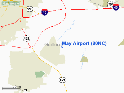
| From nearest city: | 7 nautical miles SE of Greensboro, NC |
| Location: | Guilford County, NC |
| Magnetic Variation: | 07W (1995) |
Owner & Manager
| Ownership: | Privately owned |
| Owner: | Becky May |
| Address: | 80 Kings Grant Dr
Burrils Inlet, SC 29576 |
| Phone number: | 803-238-2294 |
| Manager: | Charles G. May |
| Address: | 3729 Se School Rd.
Greensboro, NC 27406 |
| Phone number: | 336-676-0661 |
Airport Operations and Facilities
| Airport Use: | Private |
| Wind indicator: | Yes |
| Segmented Circle: | No |
| Control Tower: | No |
| Lighting Schedule: | DUSK-DAWN |
| Landing fee charge: | No |
| Sectional chart: | Charlotte |
| Region: | ASO - Southern |
| Boundary ARTCC: | ZDC - Washington |
| Responsible ARTCC: | ZTL - Atlanta |
| Tie-in FSS: | RDU - Raleigh |
| FSS on Airport: | No |
| FSS Toll Free: | 1-800-WX-BRIEF |
Airport Services
| Airframe Repair: | MINOR |
| Power Plant Repair: | MINOR |
| Bottled Oxygen: | NONE |
| Bulk Oxygen: | NONE |
Runway Information
Runway 09/27
| Dimension: | 2400 x 30 ft / 731.5 x 9.1 m |
| Surface: | ASPH, Fair Condition |
| Weight Limit: | Single wheel: 10000 lbs. |
| Edge Lights: | Non-standard lighting system
NSTD LIRL; LGTS 20 FT FM RY EDGE. |
| |
Runway 09 |
Runway 27 |
| Longitude: | 079-41-35.9770W | 079-41-06.7660W |
| Latitude: | 35-59-56.2300N | 35-59-56.3120N |
| Elevation: | 777.00 ft | 754.00 ft |
| Alignment: | 90 | 127 |
| Traffic Pattern: | Left | Left |
| Markings: | Basic, Fair Condition | Basic, Fair Condition |
| Obstruction: | 45 ft pole, 200.0 ft from runway, 110 ft left of centerline
+10 FT ROAD 160 FT FM THLD 0B & 75 FT R 0-200 FT FM THLD & +40 FT TREES 110 FT L 0-200 FT. | 70 ft trees, 650.0 ft from runway, 50 ft right of centerline, 6:1 slope to clear |
|
Radio Navigation Aids
| ID |
Type |
Name |
Ch |
Freq |
Var |
Dist |
| OQA | FAN MARKER | Rockingham County | | | | 26.6 nm |
| HB | NDB | Himun | | 361.00 | 08W | 5.2 nm |
| TOX | NDB | Siler City | | 371.00 | 07W | 18.1 nm |
| CQJ | NDB | City Lake | | 266.00 | 08W | 19.0 nm |
| SIF | NDB | Slammer | | 423.00 | 07W | 23.3 nm |
| SEN | NDB | Swearing/dcmsnd | | 260.00 | 06W | 32.4 nm |
| HUR | NDB | Person | | 220.00 | 08W | 33.4 nm |
| VU | NDB | Aller | | 346.00 | 06W | 36.1 nm |
| UV | NDB | Bales | | 396.00 | 07W | 37.2 nm |
| DVZ | NDB | Davie | | 354.00 | 06W | 37.7 nm |
| TT | NDB | Leeco | | 406.00 | 08W | 40.3 nm |
| RU | NDB | Rovdy | | 275.00 | 06W | 42.1 nm |
| EEJ | NDB | Lee County/dcmsnd | | 428.00 | 07W | 44.0 nm |
| AZW | NDB | Mount Airy | | 223.00 | 07W | 47.2 nm |
| LE | NDB | Leevy | | 350.00 | 07W | 47.3 nm |
| DAN | VOR | Danville | | 113.10 | 06W | 38.3 nm |
| LIB | VORTAC | Liberty | 077X | 113.00 | 03W | 11.9 nm |
| GSO | VORTAC | Greensboro | 109X | 116.20 | 03W | 14.2 nm |
| RDU | VORTAC | Raleigh/durham | 119X | 117.20 | 04W | 44.7 nm |
| SDZ | VORTAC | Sandhills | 055X | 111.80 | 03W | 47.4 nm |
Remarks
- 80 FT TREES WITHIN 80 FT OF CNTRLN N SIDE RY.
- RY 27 HAS 1% UPHILL GRADE.
- ULTRALIGHT ACTIVITY ON & INVOF ARPT.
- PARKED ACFT 100 FT FM CNTRLN N SIDE FIRST 500 FT RY 27.
- VFR OPNS ONLY
Images and information placed above are from
http://www.airport-data.com/airport/80NC/
We thank them for the data!
| General Info
|
| Country |
United States
|
| State |
NORTH CAROLINA
|
| FAA ID |
80NC
|
| Latitude |
35-59-56.287N
|
| Longitude |
079-41-21.395W
|
| Elevation |
777 feet
|
| Near City |
GREENSBORO
|
We don't guarantee the information is fresh and accurate. The data may
be wrong or outdated.
For more up-to-date information please refer to other sources.
|
|