 |
|
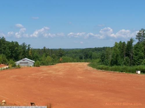 |
(Click on the photo to enlarge) |
Location & QuickFacts
| FAA Information Effective: | 2008-09-25 |
| Airport Identifier: | NC56 |
| Airport Status: | Operational |
| Longitude/Latitude: | 078-28-08.0000W/36-12-17.0000N
-78.468889/36.204722 (Estimated) |
| Elevation: | 405 ft / 123.44 m (Estimated) |
| Land: | 0 acres |
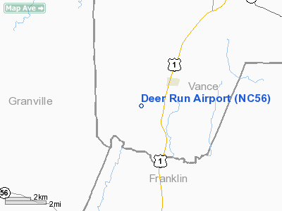
| From nearest city: | 2 nautical miles SW of Kittrell, NC |
| Location: | Vance County, NC |
| Magnetic Variation: | () |
Owner & Manager
| Ownership: | Privately owned |
| Owner: | Robert Luther Miller Iii |
| Address: | 1460 Beechtree Trail
Kittrell, NC 27544 |
| Phone number: | 252-432-3096 |
| Manager: | Robert Luther Miller Iii |
| Address: | 1460 Beechtree Trail
Kittrell, NC 27544 |
| Phone number: | 252-432-3096 |
Airport Operations and Facilities
| Airport Use: | Private |
| Wind indicator: | Yes |
| Control Tower: | No |
| Sectional chart: | Washington |
| Region: | ASO - Southern |
| Boundary ARTCC: | ZDC - Washington |
| Tie-in FSS: | RDU - Raleigh |
| FSS Toll Free: | 1-800-WX-BRIEF |
Runway Information
Runway 12/30
| Dimension: | 1600 x 100 ft / 487.7 x 30.5 m |
| Surface: | TURF, |
| |
Runway 12 |
Runway 30 |
| Traffic Pattern: | Left | Left |
|
Radio Navigation Aids
| ID |
Type |
Name |
Ch |
Freq |
Var |
Dist |
| HXO | NDB | Huntsboro | | 271.00 | 07W | 9.3 nm |
| LE | NDB | Leevy | | 350.00 | 07W | 20.7 nm |
| HUR | NDB | Person | | 220.00 | 08W | 29.0 nm |
| AEA | NDB | Jones | | 373.00 | 09W | 31.8 nm |
| MBV | NDB | Mecklenburg/dcmsnd | | 356.00 | 08W | 35.5 nm |
| RW | NDB | Jambe | | 235.00 | 09W | 35.9 nm |
| EUU | NDB | Jnall | | 251.00 | 07W | 36.4 nm |
| RZZ | NDB | Rapids | | 407.00 | 08W | 39.5 nm |
| JN | NDB | Jurly | | 263.00 | 09W | 43.9 nm |
| HQT | NDB | Harnett | | 417.00 | 08W | 47.5 nm |
| ETC | NDB | Tarboro | | 257.00 | 08W | 47.7 nm |
| JYN | NDB | Wayne | | 208.00 | 08W | 49.3 nm |
| DAN | VOR | Danville | | 113.10 | 06W | 47.4 nm |
| RDU | VORTAC | Raleigh/durham | 119X | 117.20 | 04W | 25.1 nm |
| SBV | VORTAC | South Boston | 041X | 110.40 | 05W | 38.7 nm |
| TYI | VORTAC | Tar River | 125X | 117.80 | 05W | 39.6 nm |
| LVL | VORTAC | Lawrenceville | 076X | 112.90 | 08W | 45.9 nm |
Remarks
- 473 FT TWR 2.8 NM SW, 407 FT TWR 1.7 NM E, AND 262 FT TWR 1.8 NM SE.
- PRVDD VFR OPNS AND PVT USE.
Images and information placed above are from
http://www.airport-data.com/airport/NC56/
We thank them for the data!
| General Info
|
| Country |
United States
|
| State |
NORTH CAROLINA
|
| FAA ID |
NC56
|
| Latitude |
36-04-47.000N
|
| Longitude |
076-27-48.000W
|
| Elevation |
20 feet
|
| Near City |
EDENTON
|
We don't guarantee the information is fresh and accurate. The data may
be wrong or outdated.
For more up-to-date information please refer to other sources.
|
|


