 |
|
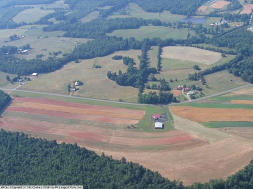 |
(Click on the photo to enlarge) |
Location & QuickFacts
| FAA Information Effective: | 2008-09-25 |
| Airport Identifier: | 8NC6 |
| Airport Status: | Operational |
| Longitude/Latitude: | 079-24-25.0720W/35-41-22.5120N
-79.406964/35.689587 (Estimated) |
| Elevation: | 620 ft / 188.98 m (Estimated) |
| Land: | 50 acres |
| From nearest city: | 4 nautical miles NW of Siler City, NC |
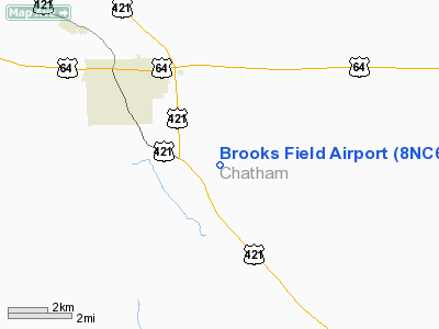
| Location: | Chatham County, NC |
| Magnetic Variation: | 06W (1985) |
Owner & Manager
| Ownership: | Privately owned |
| Owner: | Gyles Brooks |
| Address: | Rt 2 Box 573
Siler City, NC 27344 |
| Phone number: | 919-742-3423 |
| Manager: | Gyles Brooks |
| Address: | Rt 2 Box 573
Siler City, NC 27344 |
| Phone number: | 919-742-3423 |
Airport Operations and Facilities
| Airport Use: | Private |
| Wind indicator: | Yes |
| Segmented Circle: | No |
| Control Tower: | No |
| Sectional chart: | Charlotte |
| Region: | ASO - Southern |
| Boundary ARTCC: | ZDC - Washington |
| Tie-in FSS: | RDU - Raleigh |
| FSS on Airport: | No |
| FSS Toll Free: | 1-800-WX-BRIEF |
Runway Information
Runway 08/26
| Dimension: | 2200 x 75 ft / 670.6 x 22.9 m |
| Surface: | TURF, |
| |
Runway 08 |
Runway 26 |
| Traffic Pattern: | Left | Left |
| Obstruction: | 40 ft trees, 150.0 ft from runway | |
|
Radio Navigation Aids
| ID |
Type |
Name |
Ch |
Freq |
Var |
Dist |
| OQA | FAN MARKER | Rockingham County | | | | 48.8 nm |
| TOX | NDB | Siler City | | 371.00 | 07W | 5.1 nm |
| TT | NDB | Leeco | | 406.00 | 08W | 17.4 nm |
| HB | NDB | Himun | | 361.00 | 08W | 19.4 nm |
| EEJ | NDB | Lee County/dcmsnd | | 428.00 | 07W | 21.0 nm |
| CQJ | NDB | City Lake | | 266.00 | 08W | 22.4 nm |
| VU | NDB | Aller | | 346.00 | 06W | 35.1 nm |
| POB | NDB | Pope | | 338.00 | 07W | 35.6 nm |
| LE | NDB | Leevy | | 350.00 | 07W | 36.3 nm |
| HUR | NDB | Person | | 220.00 | 08W | 36.7 nm |
| HQT | NDB | Harnett | | 417.00 | 08W | 39.0 nm |
| HFF | NDB | Mackall | | 278.00 | 06W | 40.0 nm |
| SEN | NDB | Swearing/dcmsnd | | 260.00 | 06W | 43.8 nm |
| FGP | NDB | Fort Bragg | | 393.00 | 07W | 44.1 nm |
| SIF | NDB | Slammer | | 423.00 | 07W | 45.1 nm |
| JN | NDB | Jurly | | 263.00 | 09W | 49.7 nm |
| POB | TACAN | Pope | 085X | | 07W | 37.0 nm |
| FAY | VOR/DME | Fayetteville | 025X | 108.80 | 04W | 49.7 nm |
| LIB | VORTAC | Liberty | 077X | 113.00 | 03W | 12.4 nm |
| SDZ | VORTAC | Sandhills | 055X | 111.80 | 03W | 29.8 nm |
| RDU | VORTAC | Raleigh/durham | 119X | 117.20 | 04W | 32.3 nm |
| GSO | VORTAC | Greensboro | 109X | 116.20 | 03W | 35.0 nm |
Remarks
- PRVDD VFR, PRIVATE USE ONLY.
Images and information placed above are from
http://www.airport-data.com/airport/8NC6/
We thank them for the data!
| General Info
|
| Country |
United States
|
| State |
NORTH CAROLINA
|
| FAA ID |
8NC6
|
| Latitude |
35-41-22.512N
|
| Longitude |
079-24-25.072W
|
| Elevation |
620 feet
|
| Near City |
SILER CITY
|
We don't guarantee the information is fresh and accurate. The data may
be wrong or outdated.
For more up-to-date information please refer to other sources.
|
|


