 |
|
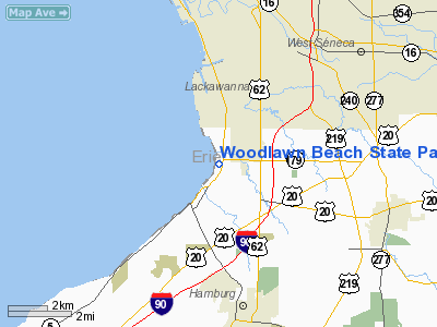
Woodlawn Beach State Park Heliport |
Location & QuickFacts
| FAA Information Effective: | 2008-09-25 |
| Airport Identifier: | 1NY0 |
| Airport Status: | Operational |
| Longitude/Latitude: | 078-50-58.1200W/42-47-17.2110N
-78.849478/42.788114 (Estimated) |
| Elevation: | 590 ft / 179.83 m (Estimated) |
| Land: | 3 acres |
| From nearest city: | 4 nautical miles NW of Hamburg, NY |
| Location: | Erie County, NY |
| Magnetic Variation: | 10W (1985) |
Owner & Manager
| Ownership: | Privately owned |
| Owner: | Ny State Parks & Rec Commission |
| Address: | S-3585 Lake Shore Road
Blasdell, NY 14219 |
| Phone number: | 716-826-1930 |
| Manager: | Kevin Mcnallie |
| Address: | S-3585 Lake Shore Road
Blasdell, NY 14219 |
| Phone number: | 716-826-1930 |
Airport Operations and Facilities
| Airport Use: | Private |
| Wind indicator: | Yes |
| Segmented Circle: | No |
| Control Tower: | No |
| Landing fee charge: | No |
| Sectional chart: | Detroit |
| Region: | AEA - Eastern |
| Boundary ARTCC: | ZOB - Cleveland |
| Tie-in FSS: | BUF - Buffalo |
| FSS on Airport: | No |
| FSS Toll Free: | 1-800-WX-BRIEF |
Airport Services
Runway Information
Helipad H1
| Dimension: | 100 x 66 ft / 30.5 x 20.1 m |
| Surface: | ASPH, Good Condition |
| |
Runway H1 |
Runway |
| Traffic Pattern: | Left | Left |
| Markings: | Basic, | , |
|
Radio Navigation Aids
| ID |
Type |
Name |
Ch |
Freq |
Var |
Dist |
| SN | NDB | St Catherines | | 408.00 | 01E | 28.0 nm |
| LYS | NDB | Olean | | 360.00 | 09W | 37.9 nm |
| AVN | NDB | Avon | | 344.00 | 09W | 49.4 nm |
| IAG | TACAN | Niagara Falls | 047X | | 10W | 20.1 nm |
| BUF | VOR/DME | Buffalo | 111X | 116.40 | 08W | 12.3 nm |
| JHW | VOR/DME | Jamestown | 094X | 114.70 | 07W | 38.0 nm |
| GEE | VOR/DME | Geneseo | 019X | 108.20 | 09W | 49.3 nm |
| DKK | VORTAC | Dunkirk | 109X | 116.20 | 07W | 25.9 nm |
| BUF | VOT | Buffalo | | 109.00 | | 10.4 nm |
Remarks
- +63' PLINES 1800 FROM THR & SOUTH OF HGR EXTDD SOUTH.
- +52' TREES, 510-525' N. OF HELIPAD
- +153' WATER TOWER, 1345' E. OF HELIPAD
- +121' BLDG., 1290' S.S.E. OF HELIPAD
- +34' POLES AND UNMARKED UTL. LINES, 400'-485' S.E. OF HELIPAD
- +15' ACCESS ROAD, 100' E. & N.E. OF HELIPAD
- PILOTS SHOULD AVOID BEACH/PARK ON LAKE ERIE (WEST OF HELIPORT)
- APPROACH/DEPARTURE PATHS TO THE SW & NE FRM HELIPAD
- 32' X 33' HELIPAD ON NORTH EDGE OF APRON
- +11' TRAILERS, 108' SE OF HELIPAD
- +120' CELL TWR, 765' SW OF HELIPAD
- +60' TREES, 150' SSE OF HELIPAD
- +52' TREES, 440' SE OF HELIPAD
- +75' TREES, 510' W. & N.W. OF HELIPAD
- +55' LIGHT POLES ON BRIDGE, 445-450' E. OF HELIPAD
- VFR ONLY
Images and information placed above are from
http://www.airport-data.com/airport/1NY0/
We thank them for the data!
| General Info
|
| Country |
United States
|
| State |
NEW YORK
|
| FAA ID |
1NY0
|
| Latitude |
42-53-00.240N
|
| Longitude |
075-59-58.716W
|
| Elevation |
1383 feet
|
| Near City |
POMPEY
|
We don't guarantee the information is fresh and accurate. The data may
be wrong or outdated.
For more up-to-date information please refer to other sources.
|
|


