 |
|
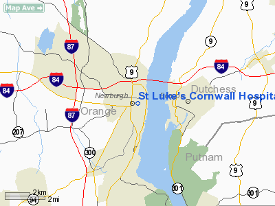
St Luke's Cornwall Hospital-newburgh Heliport |
Location & QuickFacts
| FAA Information Effective: | 2008-09-25 |
| Airport Identifier: | 8NK5 |
| Airport Status: | Operational |
| Longitude/Latitude: | 074-00-53.1800W/41-30-12.4100N
-74.014772/41.503447 (Estimated) |
| Elevation: | 193 ft / 58.83 m (Estimated) |
| Land: | 0 acres |
| From nearest city: | 1 nautical miles W of Newburgh, NY |
| Location: | Orange County, NY |
| Magnetic Variation: | () |
Owner & Manager
| Ownership: | Privately owned |
| Owner: | St. Luke's Cornwall Hospital |
| Address: | 70 Dubois St
Newburgh, NY 12550 |
| Phone number: | 845-561-4400 |
| Manager: | James Montgomery |
| Address: | 70 Dubois St
Newburgh, NY 12550 |
| Phone number: | 845-568-2502 |
Airport Operations and Facilities
| Airport Use: | Private
MEDICAL USE. |
| Wind indicator: | Yes |
| Control Tower: | No |
| Lighting Schedule: | DUSK DAWN |
| Sectional chart: | New York |
| Region: | AEA - Eastern |
| Boundary ARTCC: | ZBW - Boston |
| Tie-in FSS: | ISP - New York |
| FSS Toll Free: | 1-800-WX-BRIEF |
Runway Information
Helipad H1
| Dimension: | 60 x 50 ft / 18.3 x 15.2 m |
| Surface: | ROOF-TOP,
ALUMINUM. |
| |
Runway H1 |
Runway |
| Traffic Pattern: | Left | Left |
|
Radio Navigation Aids
| ID |
Type |
Name |
Ch |
Freq |
Var |
Dist |
| SKU | FAN MARKER | Stanwyck | | | 12W | 2.0 nm |
| GBR | FAN MARKER | Sheffield | | | 13W | 47.5 nm |
| EWR | FAN MARKER | Maryann | | | 11W | 48.7 nm |
| SKU | NDB | Stanwyck | | 261.00 | 12W | 2.0 nm |
| PO | NDB | Meier | | 403.00 | 12W | 4.9 nm |
| SW | NDB | Neely | | 335.00 | 14W | 9.7 nm |
| PNJ | NDB | Paterson | | 347.00 | 12W | 34.0 nm |
| TBY | NDB | Waterbury | | 257.00 | 14W | 39.2 nm |
| MS | NDB | Monga | | 359.00 | 12W | 41.2 nm |
| PFH | NDB | Philmont | | 272.00 | 13W | 46.9 nm |
| GBR | NDB | Great Barrington | | 395.00 | 14W | 49.2 nm |
| CAT | NDB | Chatham | | 254.00 | 11W | 49.5 nm |
| IGN | VOR/DME | Kingston | 123X | 117.60 | 12W | 13.0 nm |
| CMK | VOR/DME | Carmel | 113X | 116.60 | 12W | 23.7 nm |
| PWL | VOR/DME | Pawling | 090X | 114.30 | 12W | 24.5 nm |
| HUO | VOR/DME | Huguenot | 108X | 116.10 | 11W | 26.6 nm |
| TEB | VOR/DME | Teterboro | 021X | 108.40 | 11W | 39.4 nm |
| LGA | VOR/DME | La Guardia | 078X | 113.10 | 12W | 43.5 nm |
| BDR | VOR/DME | Bridgeport | 25X | 108.80 | 12W | 45.2 nm |
| STW | VOR/DME | Stillwater | 033X | 109.60 | 11W | 49.2 nm |
| SAX | VORTAC | Sparta | 104X | 115.70 | 11W | 35.3 nm |
| BDR | VOT | Bridgeport | | 109.25 | | 45.1 nm |
Remarks
- PRVDD VFR OPNS PVT USE, AREA IS MARKED, WIND INDICATOR IS MAINTAINED.
Images and information placed above are from
http://www.airport-data.com/airport/8NK5/
We thank them for the data!
|
|


