 |
|
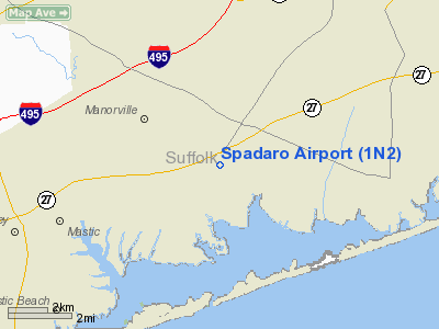
| Spadaro Airport |
| IATA: none – ICAO: none – FAA LID: 1N2 |
| Summary |
| Airport type |
Public |
| Operator |
Bart Spadaro |
| Location |
East Moriches, New York |
| Elevation AMSL |
50 ft / 15.2 m |
| Coordinates |
40°49′40.35″N 72°44′55.35″W / 40.827875°N 72.7487083°W / 40.827875; -72.7487083Coordinates: 40°49′40.35″N 72°44′55.35″W / 40.827875°N 72.7487083°W / 40.827875; -72.7487083 |
| Runways |
| Direction |
Length |
Surface |
| ft |
m |
| 18/36 |
2,400 |
732 |
Asphalt |
Spadaro Airport (FAA LID: 1N2) is a public airport located one mile (2 km) northeast of East Moriches, in Suffolk County, New York, USA. Lufker Airport is connected to Spadaro via a taxiway and aircraft are able to taxi from one airport to the other.
Facilities
Spadaro Airport covers 50 acres (200,000 m) and has one runway:
- Runway 18/36: 2,400 x 25 ft (732 x 8 m), Surface: Asphalt
The above content comes from Wikipedia and is published under free licenses – click here to read more.
Location & QuickFacts
| FAA Information Effective: | 2008-09-25 |
| Airport Identifier: | 1N2 |
| Airport Status: | Operational |
| Longitude/Latitude: | 072-44-55.3590W/40-49-40.3550N
-72.748711/40.827876 (Estimated) |
| Elevation: | 50 ft / 15.24 m (Estimated) |
| Land: | 50 acres |
| From nearest city: | 1 nautical miles NE of East Moriches, NY |
| Location: | Suffolk County, NY |
| Magnetic Variation: | 14W (1985) |
Owner & Manager
| Ownership: | Privately owned |
| Owner: | Bart Spadaro |
| Address: | 89-91 Montauk Hwy
East Moriches, NY 11940-1143 |
| Phone number: | 516-878-1125 |
| Manager: | Bart Spadaro |
| Address: | 89-91 Montauk Hwy
East Moriches, NY 11940-1143 |
| Phone number: | 516-878-1125 |
Airport Operations and Facilities
| Airport Use: | Open to public |
| Wind indicator: | Yes |
| Segmented Circle: | Yes |
| Control Tower: | No |
| Landing fee charge: | No |
| Sectional chart: | New York |
| Region: | AEA - Eastern |
| Boundary ARTCC: | ZBW - Boston |
| Responsible ARTCC: | ZNY - New York |
| Tie-in FSS: | ISP - New York |
| FSS on Airport: | No |
| FSS Toll Free: | 1-800-WX-BRIEF
FOR LOCAL CALL TO FSS DIAL 737-1000. |
| NOTAMs Facility: | ISP (NOTAM-d service avaliable) |
| Federal Agreements: | N |
Airport Communications
| CTAF: | 123.000 |
| Unicom: | 123.000 |
Airport Services
| Airframe Repair: | MAJOR |
| Power Plant Repair: | MAJOR |
| Bottled Oxygen: | NONE |
| Bulk Oxygen: | NONE |
Runway Information
Runway 18/36
| Dimension: | 2400 x 25 ft / 731.5 x 7.6 m
RWY LENGTHENED 100' EACH END
RWY WIDENED 2.5 FEET EACH SIDE |
| Surface: | ASPH, Good Condition |
| Weight Limit: | Single wheel: 12500 lbs. |
| |
Runway 18 |
Runway 36 |
| Traffic Pattern: | Left | Right |
| Markings: | Basic, Good Condition
RY 18/36 MKD WITH ORANGE GRAY STRIPED CONES 2 FT HIGH. | Basic, Good Condition |
| Displaced threshold: | 0.00 ft | 485.00 ft |
| Runway End Identifier: | No | No |
| Centerline Lights: | No | No |
| Touchdown Lights: | No | No |
| Obstruction: | 15 ft brush, 302.0 ft from runway, 6:1 slope to clear
RY 18 HAS +5 FT DIRT PILES 100 FT ON CNTRLN AND LEFT AND RIGHT OF CNTRLN, +41 FT TREES 81 FT FM RY, 116 FT RIGHT. | 33 ft pline, 201.0 ft from runway
RY 36 HAS +55 FT TREES, 321 FT FM RY ON CNTRLN, 14:1 BASED ON DSPLCD THLD.
HAS +31 FT BLDG, 48 FT FM RY, 133 FT LEFT; +17 FT BLDG, 41 FT FM RY, 93 FT LEFT; +28 FT BLDG, 70 FT FM RY, 65 FT LEFT; +13 FT BLDG, 43 FT FM RY, 72 FT LEFT; +28 FT BLDG, 70 FT FM RY, 65 FT LEFT; +10 FT BLDG, 49 FT FM RY, 35 FT LEFT; +14 FT BLDG, 165 FT FM RY, BOTH SIDES. |
|
Radio Navigation Aids
| ID |
Type |
Name |
Ch |
Freq |
Var |
Dist |
| OP | NDB | Old Field Point Light | | 316.00 | 13W | 19.0 nm |
| BBN | NDB | Babylon | | 275.00 | 14W | 30.4 nm |
| MMK | NDB | Meriden | | 238.00 | 14W | 41.2 nm |
| TBY | NDB | Waterbury | | 257.00 | 14W | 45.8 nm |
| HF | NDB | Lomis | | 244.00 | 15W | 48.9 nm |
| FOK | TACAN | Suffolk Co | 047X | | 13W | 5.3 nm |
| CCC | VOR/DME | Calverton | 119X | 117.20 | 13W | 6.5 nm |
| DPK | VOR/DME | Deer Park | 124X | 117.70 | 12W | 25.3 nm |
| BDR | VOR/DME | Bridgeport | 25X | 108.80 | 12W | 26.3 nm |
| HVN | VOR/DME | New Haven | 035X | 109.80 | 13W | 26.8 nm |
| MAD | VOR/DME | Madison | 041X | 110.40 | 13W | 29.3 nm |
| GON | VOR/DME | Groton | 45Y | 110.85 | 14W | 43.7 nm |
| CMK | VOR/DME | Carmel | 113X | 116.60 | 12W | 46.5 nm |
| JFK | VOR/DME | Kennedy | 106X | 115.90 | 12W | 48.0 nm |
| HFD | VOR/DME | Hartford | 096X | 114.90 | 13W | 49.7 nm |
| HTO | VORTAC | Hampton | 083X | 113.60 | 13W | 20.4 nm |
| ISP | VOT | Long Island Mac Arthur | | 109.40 | | 15.9 nm |
| BDR | VOT | Bridgeport | | 109.25 | | 26.4 nm |
| GON | VOT | Groton | | 110.25 | | 43.5 nm |
| JFK | VOT | Kennedy | | 115.10 | | 48.4 nm |
Remarks
- DUE TO CLOSE PROXIMITY OF LUFKER ARPT /590 FT BTN RYS/ADHERE TO FLWG TFC PAT: N OPN--SPADARO RP LUFKER LP. S OPN--SPADARO LP LUFKER RP. ARR: INTERCEPT FINAL APCH AT 45 DEG TO FINAL APCH LEG 1500 FT FM APCH END OF RWY. DEP: MAKE 45 DEG TURN ASAP AFT TKOF TO INTCP CROSSWIND LEG.
- USE S OPN FOR LNDG WHEN WINDS ARE 5 KTS OR LESS; OR WHEN WINDS ARE MORE THAN 5 KTS 90 DEG EITHER SIDE OF CNTRLN.
- USE N OPN FOR TKOF WITH NO WIND; HVY GWT; AND FOR NOISE ABATEMENT.
- ULTRALGTS ON & INVOF ARPT.
- RY 18/36 HAS +14 VARIOUS RV'S, PLANES & BLDGS, 55 FT TO 90 FT FM RY CNTRLN BOTH SIDES, FULL LENGTH OF RY.
- RY 18 HAS +39 FT PLINE, 963 FT FM RY BOTH SIDES.
Images and information placed above are from
http://www.airport-data.com/airport/1N2/
We thank them for the data!
| General Info
|
| Country |
United States
|
| State |
NEW YORK
|
| FAA ID |
1N2
|
| Latitude |
40-49-40.355N
|
| Longitude |
072-44-55.359W
|
| Elevation |
50 feet
|
| Near City |
EAST MORICHES
|
We don't guarantee the information is fresh and accurate. The data may
be wrong or outdated.
For more up-to-date information please refer to other sources.
|
|


