 |
|
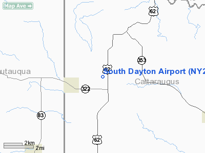
Location & QuickFacts
| FAA Information Effective: | 2008-09-25 |
| Airport Identifier: | NY27 |
| Airport Status: | Operational |
| Longitude/Latitude: | 079-00-34.1370W/42-22-15.2180N
-79.009482/42.370894 (Estimated) |
| Elevation: | 1300 ft / 396.24 m (Estimated) |
| Land: | 500 acres |
| From nearest city: | 2 nautical miles E of South Dayton, NY |
| Location: | Cattaraugus County, NY |
| Magnetic Variation: | 09W (1985) |
Owner & Manager
| Ownership: | Privately owned |
| Owner: | Van Bron Corp. |
| Address: | Rt 62 - Box 285
South Dayton, NY 14138 |
| Phone number: | 716-988-3252 |
| Manager: | Dave Van Wormer |
| Address: | 8501 Route 62
South Dayton, NY 14138-0285 |
| Phone number: | 716-988-3252 |
Airport Operations and Facilities
| Airport Use: | Private |
| Wind indicator: | Yes |
| Segmented Circle: | No |
| Control Tower: | No |
| Lighting Schedule: | PHONE REQ
FOR LIRL RY 09/27 & 18/36 CALL 716-988-3252. |
| Landing fee charge: | No |
| Sectional chart: | Detroit |
| Region: | AEA - Eastern |
| Boundary ARTCC: | ZOB - Cleveland |
| Tie-in FSS: | BUF - Buffalo |
| FSS on Airport: | No |
| FSS Toll Free: | 1-800-WX-BRIEF |
Airport Services
Runway Information
Runway 09/27
| Dimension: | 3745 x 60 ft / 1141.5 x 18.3 m |
| Surface: | TURF, Good Condition |
| Edge Lights: | Non-standard lighting system
& 18/36 NSTD LIRL. |
| |
Runway 09 |
Runway 27 |
| Traffic Pattern: | Left | Left |
| Obstruction: | 39 ft plines, 24.0 ft from runway, 1:1 slope to clear | 38 ft pline, 90.0 ft from runway, 2:1 slope to clear |
|
Runway 18/36
| Dimension: | 3880 x 60 ft / 1182.6 x 18.3 m |
| Surface: | TURF, Good Condition |
| Edge Lights: | Non-standard lighting system
& 18/36 NSTD LIRL. |
| |
Runway 18 |
Runway 36 |
| Traffic Pattern: | Left | Left |
| Obstruction: | 97 ft bldg, 3650.0 ft from runway, 256 ft left of centerline, 37:1 slope to clear | 23 ft trees, 0.0 ft from runway, 70 ft right of centerline, 1:1 slope to clear |
|
Radio Navigation Aids
| ID |
Type |
Name |
Ch |
Freq |
Var |
Dist |
| LYS | NDB | Olean | | 360.00 | 09W | 30.4 nm |
| ORJ | NDB | Corry | | 258.00 | 09W | 39.6 nm |
| SN | NDB | St Catherines | | 408.00 | 01E | 47.9 nm |
| IAG | TACAN | Niagara Falls | 047X | | 10W | 44.6 nm |
| JHW | VOR/DME | Jamestown | 094X | 114.70 | 07W | 12.0 nm |
| BUF | VOR/DME | Buffalo | 111X | 116.40 | 08W | 37.2 nm |
| BFD | VOR/DME | Bradford | 113X | 116.60 | 07W | 39.2 nm |
| DKK | VORTAC | Dunkirk | 109X | 116.20 | 07W | 13.8 nm |
| TDT | VORTAC | Tidioute | 123X | 117.60 | 09W | 43.5 nm |
| ELZ | VORTAC | Wellsville | 051X | 111.40 | 09W | 48.0 nm |
| BUF | VOT | Buffalo | | 109.00 | | 36.3 nm |
Remarks
- WINTER TIME CHECK TO BE SURE RWYS ARE OPEN.
Images and information placed above are from
http://www.airport-data.com/airport/NY27/
We thank them for the data!
| General Info
|
| Country |
United States
|
| State |
NEW YORK
|
| FAA ID |
NY27
|
| Latitude |
42-22-15.218N
|
| Longitude |
079-00-34.137W
|
| Elevation |
1300 feet
|
| Near City |
SOUTH DAYTON
|
We don't guarantee the information is fresh and accurate. The data may
be wrong or outdated.
For more up-to-date information please refer to other sources.
|
|


