 |
|
Location & QuickFacts
| FAA Information Effective: | 2008-09-25 |
| Airport Identifier: | NY85 |
| Airport Status: | Operational |
| Longitude/Latitude: | 075-18-49.6100W/43-14-58.2500N
-75.313781/43.249514 (Estimated) |
| Elevation: | 930 ft / 283.46 m (Estimated) |
| Land: | 0 acres |
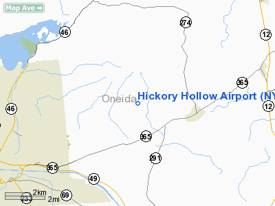
| From nearest city: | 2 nautical miles NE of Floyd, NY |
| Location: | Oneida County, NY |
| Magnetic Variation: | 13W (1985) |
Owner & Manager
| Ownership: | Privately owned |
| Owner: | Wesley P. Farney |
| Address: | 7986 Soule Road
Holland Patent, NY 13354 |
| Phone number: | 315-865-5537 |
| Address: |
|
Airport Operations and Facilities
| Airport Use: | Private |
| Wind indicator: | No |
| Segmented Circle: | No |
| Control Tower: | No |
| Landing fee charge: | No |
| Sectional chart: | New York |
| Region: | AEA - Eastern |
| Boundary ARTCC: | ZBW - Boston |
| Tie-in FSS: | BUF - Buffalo |
| FSS on Airport: | No |
| FSS Toll Free: | 1-800-WX-BRIEF |
Airport Services
| Airframe Repair: | NONE |
| Power Plant Repair: | NONE |
Runway Information
Runway E/W
| Dimension: | 1800 x 40 ft / 548.6 x 12.2 m
FULL LENGTH OF RWY NOT USABLE DUE TO CONSTRUCTION. |
| Surface: | TURF,
1000' CENTER PORTION ASPH. |
| |
Runway E |
Runway W |
| Traffic Pattern: | Left | Left |
|
Runway N/S
| Dimension: | 1800 x 40 ft / 548.6 x 12.2 m
FULL LENGTH OF RWY NOT USABLE DUE TO CONSTRUCTION. |
| Surface: | ASPH-TURF,
1000' CENTER PORTION ASPH. |
| |
Runway N |
Runway S |
| Traffic Pattern: | Left | Left |
| Obstruction: | 25 ft pline | |
|
Radio Navigation Aids
| ID |
Type |
Name |
Ch |
Freq |
Var |
Dist |
| BK | NDB | Plein | | 329.00 | 12W | 7.6 nm |
| CJY | NDB | Clay | | 275.00 | 12W | 12.0 nm |
| JJH | NDB | Johnstown | | 523.00 | 14W | 45.6 nm |
| GSS | TACAN | Griffiss | 057X | | 12W | 4.4 nm |
| RKA | VOR/DME | Rockdale | 073X | 112.60 | 11W | 47.2 nm |
| UCA | VORTAC | Utica | 049X | 111.20 | 12W | 14.9 nm |
| GGT | VORTAC | Georgetown | 125X | 117.80 | 11W | 35.7 nm |
| SYR | VORTAC | Syracuse | 117X | 117.00 | 11W | 39.4 nm |
Remarks
- EARTHMOVING OPNS PRESENTLY UNDERWAY; FIELD IS WI A PVT WILDLIFE REFUGE; HORSES &/OR DEER MAY BE ON FIELD.
Images and information placed above are from
http://www.airport-data.com/airport/NY85/
We thank them for the data!
| General Info
|
| Country |
United States
|
| State |
NEW YORK
|
| FAA ID |
NY85
|
| Latitude |
43-14-58.250N
|
| Longitude |
075-18-49.610W
|
| Elevation |
930 feet
|
| Near City |
FLOYD
|
We don't guarantee the information is fresh and accurate. The data may
be wrong or outdated.
For more up-to-date information please refer to other sources.
|
|


