 |
|
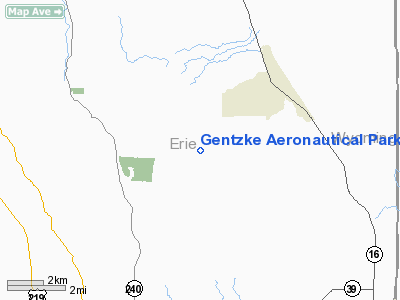
Gentzke Aeronautical Park Airport |
Location & QuickFacts
| FAA Information Effective: | 2008-09-25 |
| Airport Identifier: | NY40 |
| Airport Status: | Operational |
| Longitude/Latitude: | 078-35-44.0860W/42-36-38.2200N
-78.595579/42.610617 (Estimated) |
| Elevation: | 1750 ft / 533.40 m (Estimated) |
| Land: | 77 acres |
| From nearest city: | 4 nautical miles SW of Holland, NY |
| Location: | Erie County, NY |
| Magnetic Variation: | 10W (1985) |
Owner & Manager
| Ownership: | Privately owned |
| Owner: | Glenn D. Gentzke |
| Address: | 10661 Crump Rd
Holland, NY 14080 |
| Phone number: | 716 592-2023 |
| Manager: | Glenn D. Gentzke |
| Address: | 10661 Crump Rd
Holland, NY 14080 |
| Phone number: | 716 592-2023 |
Airport Operations and Facilities
| Airport Use: | Private |
| Wind indicator: | Yes |
| Segmented Circle: | No |
| Control Tower: | No |
| Sectional chart: | Detroit |
| Region: | AEA - Eastern |
| Boundary ARTCC: | ZOB - Cleveland |
| Tie-in FSS: | BUF - Buffalo |
| FSS Toll Free: | 1-800-WX-BRIEF |
Runway Information
Runway E/W
| Dimension: | 2000 x 100 ft / 609.6 x 30.5 m |
| Surface: | TURF, |
| |
Runway E |
Runway W |
| Traffic Pattern: | Left | Left |
| Obstruction: | | 50 ft trees, 500.0 ft from runway |
|
Radio Navigation Aids
| ID |
Type |
Name |
Ch |
Freq |
Var |
Dist |
| LYS | NDB | Olean | | 360.00 | 09W | 22.8 nm |
| EL | NDB | Halos | | 269.00 | 09W | 42.6 nm |
| SN | NDB | St Catherines | | 408.00 | 01E | 43.4 nm |
| AVN | NDB | Avon | | 344.00 | 09W | 43.6 nm |
| IAG | TACAN | Niagara Falls | 047X | | 10W | 34.2 nm |
| BUF | VOR/DME | Buffalo | 111X | 116.40 | 08W | 19.3 nm |
| JHW | VOR/DME | Jamestown | 094X | 114.70 | 07W | 34.5 nm |
| GEE | VOR/DME | Geneseo | 019X | 108.20 | 09W | 40.4 nm |
| BFD | VOR/DME | Bradford | 113X | 116.60 | 07W | 49.6 nm |
| DKK | VORTAC | Dunkirk | 109X | 116.20 | 07W | 30.9 nm |
| ELZ | VORTAC | Wellsville | 051X | 111.40 | 09W | 41.0 nm |
| BUF | VOT | Buffalo | | 109.00 | | 20.7 nm |
Remarks
- TREES NORTH & EAST BE REMOVED; LIMITED TO AIRCRAFT UNDER 12500 LBS
Images and information placed above are from
http://www.airport-data.com/airport/NY40/
We thank them for the data!
| General Info
|
| Country |
United States
|
| State |
NEW YORK
|
| FAA ID |
NY40
|
| Latitude |
42-36-38.220N
|
| Longitude |
078-35-44.086W
|
| Elevation |
1750 feet
|
| Near City |
HOLLAND
|
We don't guarantee the information is fresh and accurate. The data may
be wrong or outdated.
For more up-to-date information please refer to other sources.
|
|


