|
|
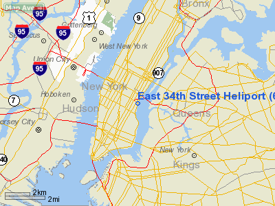
East 34th Street Heliport |
| East 34th Street Heliport |
 |
| IATA: TSS – ICAO: none – FAA LID: 6N5 |
| Summary |
| Airport type |
Public |
| Owner |
Economic Development Corp |
| Operator |
Mac Quarie Aviation |
| Serves |
New York City |
| Location |
New York City, New York |
| Elevation AMSL |
10 ft / 3 m |
| Coordinates |
40°44′33″N 073°58′19″W / 40.7425°N 73.97194°W / 40.7425; -73.97194Coordinates: 40°44′33″N 073°58′19″W / 40.7425°N 73.97194°W / 40.7425; -73.97194 |
| Helipads |
| Number |
Length |
Surface |
| ft |
m |
| 1 |
304 |
93 |
Asphalt |
| 2 |
44 |
13 |
Asphalt |
| 3 |
44 |
13 |
Asphalt |
| 4 |
44 |
13 |
Asphalt |
| T |
44 |
13 |
Asphalt |
| Source: Airnav: |
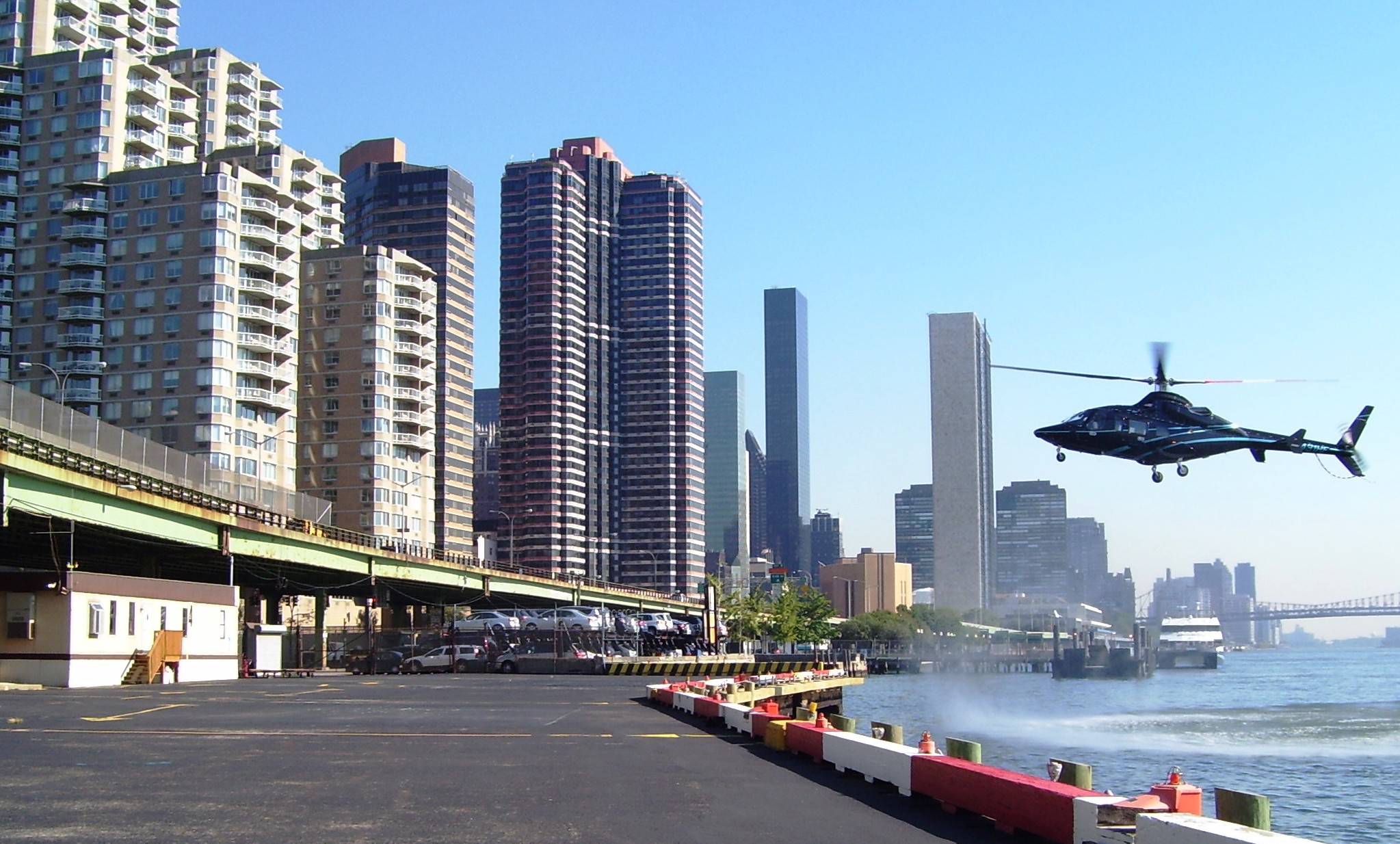
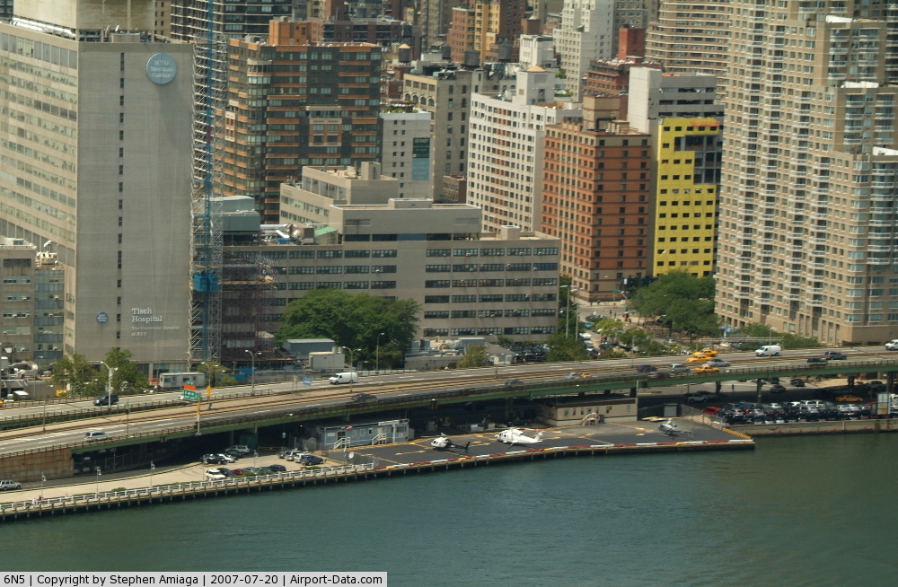
East 34th Street Heliport (IATA: TSS, FAA LID: 6N5) is a heliport on the east side of Manhattan located between the East River and the FDR Drive viaduct. Also known as the Atlantic Metroport at East 34th Street, it is a public heliport owned by New York City and run by the Economic Development Corporation.
The East 34th Street Heliport opened in 1972, providing charter, commuter, and sightseeing flights, and served as a replacement for the heliport atop the Pan Am Building, which closed in 1968. After several residential high rises were developed in the neighborhood in the 1980s, the city was pressured into reducing helicopter traffic in the area. Sightseeing flights were banned from the heliport in 1997. In 1998, operations were further restricted by limiting flights from 8 am to 8 pm on weekdays and from 10 am to 6 pm on weekends. Weekend flights were banned altogether later in the year.
US Helicopter began providing regularly scheduled passenger service from the East 34th Street Heliport to John F. Kennedy International Airport and Newark Liberty International Airport in 2007, but shut down operations in September 2009. As of November 2009, it was uncertain if or when scheduled shuttle service would start up again. Operations
Since this is a heliport and not an airport, there are no Instrument Procedures for this facility. The level of boating traffic in the neighboring East River requires that pilots exercise caution in making their approach to the heliport's landing pad.
Airlines
- US Helicopter (New York-JFK, until September 2009)
Statistics
72% of the flights are airtaxi, 18% general aviation, 9% commuters, and less than 1% military.
Accidents and incidents
- On May 23, 1974, David Frank Kamaiko, a 22-year man from Greenwich Village claiming to be a member of the Jewish Defense League, hijacked a helicopter from the East 34th Street Heliport and demanded $2 million in ransom. After landing on top of the Pan Am Building, the pilot tried to escape and Kamaiko shot him in the arm. The hijacker was held back by the other hostage inside the helicopter until he was taken into custody by police.
- On February 27, 1975, a Bell 47G-2A on a non-commercial flight from Garden City crashed into a fence while attempting to land at the 34th Street Heliport in gusty wind conditions. The pilot survived but was severely burned in the resulting fire.
- On April 26, 1985, the engine on a Aérospatiale SA 360 Dauphin failed shortly after takeoff from the East 34th Street Heliport, sending the helicopter into the East River. Five passengers and two crewmembers were rescued from but one passenger trapped inside the submerged craft was killed.
- On May 2, 1988, a Bell 206-B on a sightseeing flight around Manhattan crashed into the East River near Long Island City while preparing to land at the East 34th Street Heliport, killing one person and injuring four others.
- On February 10, 1990, a strong gust of wind sent a Bell 206-L on a sightseeing flight crashing into the East River shortly after taking off from the East 34th Street Heliport. A 14-year old boy was unconscious when pulled from the wreckage and later died. The pilot and three other passengers (including the boy's father and two French tourists) were injured but survived the crash.
- On June 17, 2005, a Sikorsky S-76C carrying six corporate executives from MBNA returning to Delaware after a business meeting in New York City crashed into the East River less than one minute after taking off from the East 34th Street Heliport. All eight people aboard survived the crash.
The above content comes from Wikipedia and is published under free licenses – click here to read more.
 |
(Click on the photo to enlarge) |
Location & QuickFacts
| FAA Information Effective: | 2008-09-25 |
| Airport Identifier: | 6N5 |
| Airport Status: | Operational |
| Longitude/Latitude: | 073-58-19.4990W/40-44-33.3660N
-73.972083/40.742602 (Estimated) |
| Elevation: | 10 ft / 3.05 m (Estimated) |
| Land: | 0 acres |
| From nearest city: | 0 nautical miles E of New York, NY |
| Location: | New York County, NY |
| Magnetic Variation: | 13W (1985) |
Owner & Manager
| Ownership: | Publicly owned |
| Owner: | Economic Development Corp |
| Address: | 110 William St
New York, NY 10038 |
| Phone number: | 212-312-3616 |
| Manager: | Mac Quarie Aviation Na |
| Address: | Macquarrie Aviation Na, 499 E. 34th St. & F.d.r. Dr.
New York, NY 10016 |
| Phone number: | 212-889-2551 |
Airport Operations and Facilities
| Airport Use: | Open to public |
| Wind indicator: | Yes |
| Segmented Circle: | No |
| Control Tower: | No |
| Lighting Schedule: | DUSK-DAWN
BCN LCTD ABOVE OFFICE TRAILER BLO ELEVATED HIGHWAY. |
| Beacon Color: | Clear-Green-Yellow (heliport) |
| Landing fee charge: | Yes |
| Sectional chart: | New York |
| Region: | AEA - Eastern |
| Boundary ARTCC: | ZNY - New York |
| Tie-in FSS: | ISP - New York |
| FSS on Airport: | No |
| FSS Toll Free: | 1-800-WX-BRIEF |
| NOTAMs Facility: | ISP (NOTAM-d service avaliable) |
| Federal Agreements: | N |
Airport Communications
| CTAF: | 123.075 |
| Unicom: | 123.075 |
Airport Services
| Fuel available: | A1 |
| Airframe Repair: | NONE |
| Power Plant Repair: | NONE |
Runway Information
Helipad H-T
| Dimension: | 44 x 44 ft / 13.4 x 13.4 m
ADD'L 7.5 TO BULKHEAD.
ADD'L 7.5 FT TO BULKHEAD.
ADD'L 7.5 TO BULKHEAD.
ADD'L 7.5 TO BULKHEAD.
ADD'L 7.5 TO BULKHEAD. |
| Surface: | ASPH, Good Condition |
| Edge Lights: | Non-standard lighting system
NSTD RED PERIMETER LGTS. |
| |
Runway H-T |
Runway |
| Traffic Pattern: | Left | Left |
|
Helipad H1
| Dimension: | 37 x 37 ft / 11.3 x 11.3 m
ADD'L 7.5 TO BULKHEAD.
ADD'L 7.5 FT TO BULKHEAD.
ADD'L 7.5 TO BULKHEAD.
ADD'L 7.5 TO BULKHEAD.
ADD'L 7.5 TO BULKHEAD. |
| Surface: | ASPH-CONC, Good Condition |
| Edge Lights: | Non-standard lighting system
NSTD RED PERIMETER LGTS. |
| |
Runway H1 |
Runway |
| Traffic Pattern: | Left | Left |
| Markings: | Nonstandard, Good Condition | , |
|
Helipad H2
| Dimension: | 44 x 44 ft / 13.4 x 13.4 m
ADD'L 7.5 TO BULKHEAD.
ADD'L 7.5 FT TO BULKHEAD.
ADD'L 7.5 TO BULKHEAD.
ADD'L 7.5 TO BULKHEAD.
ADD'L 7.5 TO BULKHEAD. |
| Surface: | ASPH, Good Condition |
| Edge Lights: | Non-standard lighting system
NSTD RED PERIMETER LGTS. |
| |
Runway H2 |
Runway |
| Traffic Pattern: | Left | Left |
|
Helipad H3
| Dimension: | 44 x 44 ft / 13.4 x 13.4 m
ADD'L 7.5 TO BULKHEAD.
ADD'L 7.5 FT TO BULKHEAD.
ADD'L 7.5 TO BULKHEAD.
ADD'L 7.5 TO BULKHEAD.
ADD'L 7.5 TO BULKHEAD. |
| Surface: | ASPH, Good Condition |
| Edge Lights: | Non-standard lighting system
NSTD RED PERIMETER LGTS. |
| |
Runway H3 |
Runway |
| Traffic Pattern: | Left | Left |
|
Helipad H4
| Dimension: | 44 x 44 ft / 13.4 x 13.4 m
ADD'L 7.5 TO BULKHEAD.
ADD'L 7.5 FT TO BULKHEAD.
ADD'L 7.5 TO BULKHEAD.
ADD'L 7.5 TO BULKHEAD.
ADD'L 7.5 TO BULKHEAD. |
| Surface: | ASPH, Good Condition |
| Edge Lights: | Non-standard lighting system
NSTD RED PERIMETER LGTS. |
| |
Runway H4 |
Runway |
| Traffic Pattern: | Left | Left |
|
Radio Navigation Aids
| ID |
Type |
Name |
Ch |
Freq |
Var |
Dist |
| EWR | FAN MARKER | Maryann | | | 11W | 10.1 nm |
| SKU | FAN MARKER | Stanwyck | | | 12W | 47.3 nm |
| OGY | NDB | Bridge | | 414.00 | 12W | 11.2 nm |
| PNJ | NDB | Paterson | | 347.00 | 12W | 14.7 nm |
| CAT | NDB | Chatham | | 254.00 | 11W | 20.8 nm |
| BBN | NDB | Babylon | | 275.00 | 14W | 27.1 nm |
| OP | NDB | Old Field Point Light | | 316.00 | 13W | 41.3 nm |
| NEL | NDB | Lakehurst | | 396.00 | 13W | 45.1 nm |
| SW | NDB | Neely | | 335.00 | 14W | 46.2 nm |
| SKU | NDB | Stanwyck | | 261.00 | 12W | 47.3 nm |
| NEL | TACAN | Lakehurst | 055X | | 11W | 45.9 nm |
| NEL | UHF/NDB | Lakehurst | | 274.80 | 13W | 45.1 nm |
| LGA | VOR/DME | La Guardia | 078X | 113.10 | 12W | 5.1 nm |
| TEB | VOR/DME | Teterboro | 021X | 108.40 | 11W | 7.6 nm |
| CRI | VOR/DME | Canarsie | 070X | 112.30 | 11W | 8.6 nm |
| JFK | VOR/DME | Kennedy | 106X | 115.90 | 12W | 11.3 nm |
| COL | VOR/DME | Colts Neck | 101X | 115.40 | 11W | 27.3 nm |
| DPK | VOR/DME | Deer Park | 124X | 117.70 | 12W | 30.6 nm |
| SBJ | VOR/DME | Solberg | 076X | 112.90 | 10W | 36.4 nm |
| CMK | VOR/DME | Carmel | 113X | 116.60 | 12W | 36.8 nm |
| BWZ | VOR/DME | Broadway | 089X | 114.20 | 11W | 38.8 nm |
| STW | VOR/DME | Stillwater | 033X | 109.60 | 11W | 43.5 nm |
| BDR | VOR/DME | Bridgeport | 25X | 108.80 | 12W | 46.0 nm |
| HUO | VOR/DME | Huguenot | 108X | 116.10 | 11W | 48.9 nm |
| SAX | VORTAC | Sparta | 104X | 115.70 | 11W | 32.3 nm |
| RBV | VORTAC | Robbinsville | 085X | 113.80 | 10W | 40.3 nm |
| JFK | VOT | Kennedy | | 115.10 | | 10.9 nm |
| ISP | VOT | Long Island Mac Arthur | | 109.40 | | 40.0 nm |
| BDR | VOT | Bridgeport | | 109.25 | | 45.9 nm |
Remarks
- HELIPORT CLSD SAT & SUN.
- ALL OPNS OVER EAST RIVER.
- NO LATE OR EARLY OPNS AVBL.
- CALL AHEAD FOR PARKING.
- "NX RAD" WX SYSTEM AVBL.
- IFR CLNC LGA 1-718-779-7901.
- VFR ONLY. NO INGRESS/EGRESS OVER FDR DRIVE.
Images and information placed above are from
http://www.airport-data.com/airport/6N5/
We thank them for the data!
| General Info
|
| Country |
United States
|
| State |
NEW YORK
|
| FAA ID |
6N5
|
| Latitude |
40-44-33.366N
|
| Longitude |
073-58-19.499W
|
| Elevation |
10 feet
|
| Near City |
NEW YORK
|
We don't guarantee the information is fresh and accurate. The data may
be wrong or outdated.
For more up-to-date information please refer to other sources.
|
|