 |
|
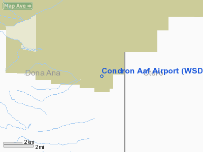
Location & QuickFacts
| FAA Information Effective: | 2008-09-25 |
| Airport Identifier: | WSD |
| Airport Status: | Operational |
| Longitude/Latitude: | 106-24-09.9660W/32-20-29.3390N
-106.402768/32.341483 (Estimated) |
| Elevation: | 3934 ft / 1199.08 m (Estimated) |
| Land: | 0 acres |
| From nearest city: | 3 nautical miles S of White Sands, NM |
| Location: | Dona Ana County, NM |
| Magnetic Variation: | 11E (1985) |
Owner & Manager
| Ownership: | Army owned |
| Owner: | Us Army Atca-aso |
| Address: | Cameron Station
Alexandria, VA 22314 |
| Address: |
|
Airport Operations and Facilities
| Airport Use: | Private |
| Segmented Circle: | No |
| Control Tower: | No |
| Lighting Schedule: | RDO-CTL
ACTIVATE-MIRL RWY 9-27-122.8, KEY MIKE 5 TIMES. |
| Beacon Color: | Split-Clear-Green (lighted military airport) |
| Sectional chart: | Phoenix |
| Region: | ASW - Southwest |
| Boundary ARTCC: | ZAB - Albuquerque |
| Tie-in FSS: | ABQ - Albuquerque |
| FSS on Airport: | No |
| FSS Toll Free: | 1-800-WX-BRIEF |
Airport Communications
Runway Information
Runway 01/19
| Dimension: | 4350 x 150 ft / 1325.9 x 45.7 m |
| Surface: | GRAVEL, |
| Weight Limit: | Single wheel: 20000 lbs. |
| |
Runway 01 |
Runway 19 |
| Traffic Pattern: | Right | Left |
|
Runway 09/27
| Dimension: | 6125 x 75 ft / 1866.9 x 22.9 m |
| Surface: | ASPH, |
| Weight Limit: | Dual wheel: 82000 lbs. |
| Edge Lights: | Medium |
| |
Runway 09 |
Runway 27 |
| Traffic Pattern: | Left | Right |
|
Radio Navigation Aids
| ID |
Type |
Name |
Ch |
Freq |
Var |
Dist |
| EL | NDB | Valtr | | 242.00 | 11E | 29.2 nm |
| ALM | NDB | Alamogordo | | 341.00 | 11E | 37.3 nm |
| HMN | TACAN | Holloman | 092X | | 10E | 34.6 nm |
| BWS | VOR/DME | Boles | 033X | 109.60 | 11E | 34.9 nm |
| CJS | VOR/DME | Ciudad Juarez | 114X | 116.70 | 11E | 42.4 nm |
| EWM | VORTAC | Newman | 071X | 112.40 | 12E | 24.3 nm |
| ELP | VORTAC | El Paso | 099X | 115.20 | 12E | 32.2 nm |
| ELP | VOT | El Paso Intl | | 111.00 | | 32.1 nm |
Remarks
- RSTD: 24 HR PPR DSN 349-1315/C575-679-1315.
- RSTD: AVOID HI-PWR AND REVERSE THRUST OPR IF POSSIBLE.
- RSTD: ACFT LDG ARE RQR TO MAKE LO APCH TO INSURE RWY CLEAR OF OBST AND WILDLIFE.
- CAUTION: MT 4 NM W.
- RSTD: ARR FR S MUST HAVE CLNC THRU R5107A FR MCGREGOR RNG 397.7 41.7. CTC CHEROKEE PRIOR TO ENTRY R5107B.
- RSTD: RWY 1-19 FOR USE BY TACTICAL F/W AND R/W ACFT ONLY.
- MISC: GND CREW CK DIRT RWY COND PRIOR TO FLT OPR.
- MISC: MID-FLD DIAGONAL TWY CLSD EXC LCL DRONE OPR.
- CAUTION: AFLD UNMANNED.
- CAUTION: FOD HAZ/SMALL ROCKS AND GRAVEL ON RWY AND ALL MOVEMENT AREAS.
Images and information placed above are from
http://www.airport-data.com/airport/WSD/
We thank them for the data!
| General Info
|
| Country |
United States
|
| State |
NEW MEXICO
|
| FAA ID |
WSD
|
| Latitude |
32-20-29.339N
|
| Longitude |
106-24-09.966W
|
| Elevation |
3934 feet
|
| Near City |
WHITE SANDS
|
We don't guarantee the information is fresh and accurate. The data may
be wrong or outdated.
For more up-to-date information please refer to other sources.
|
|


