|
|
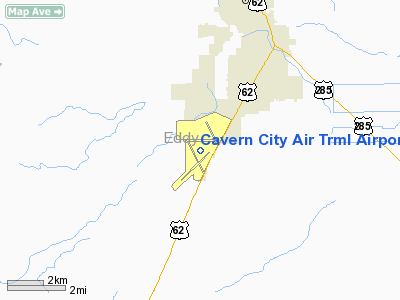
Cavern City Air Trml Airport |
| Cavern City Air Terminal |
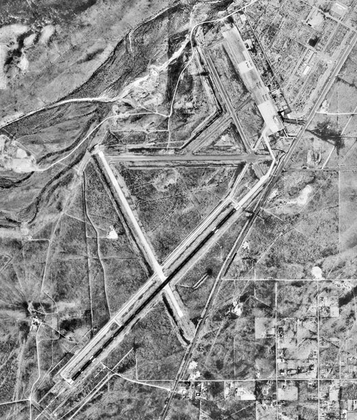 |
| USGS aerial image, 19 October 1997 |
| IATA: CNM – ICAO: KCNM – FAA LID: CNM |
| Summary |
| Airport type |
Public |
| Owner |
City of Carlsbad |
| Serves |
Carlsbad, New Mexico |
| Elevation AMSL |
3,295 ft / 1,004 m |
| Coordinates |
32°20′15″N 104°15′48″W / 32.3375°N 104.26333°W / 32.3375; -104.26333Coordinates: 32°20′15″N 104°15′48″W / 32.3375°N 104.26333°W / 32.3375; -104.26333 |
| Runways |
| Direction |
Length |
Surface |
| ft |
m |
| 3/21 |
7,854 |
2,394 |
Asphalt |
| 8/26 |
5,333 |
1,625 |
Asphalt |
| 14L/32R |
4,615 |
1,407 |
Asphalt |
| 14R/32L |
5,839 |
1,780 |
Asphalt |
| Statistics (2007) |
| Aircraft operations |
19,300 |
| Based aircraft |
26 |
| Source: Federal Aviation Administration |
Cavern City Air Terminal (IATA: CNM, ICAO: KCNM, FAA LID: CNM) is a city-owned public-use airport located five miles (8 km) southwest of the central business district of Carlsbad, a city in Eddy County, New Mexico, United States. It is served by one commercial airline, with service subsidized by the Essential Air Service program. Airline and destinations
- New Mexico Airlines (Albuquerque, El Paso, Hobbs)
Facilities and aircraft
Cavern City Air Terminal covers an area of 1,980 acres (801 ha) which contains four runways:
- Runway 3/21: 7,854 x 150 ft. (2,394 x 46 m), Surface: Asphalt
- Runway 8/26: 5,333 x 75 ft. (1,625 x 23 m), Surface: Asphalt
- Runway 14L/32R: 4,615 x 150 ft. (1,407 x 46 m), Surface: Asphalt
- Runway 14R/32L: 5,839 x 100 ft. (1,780 x 30 m), Surface: Asphalt
For the 12-month period ending April 30, 2007, the airport had 19,300 aircraft operations, an average of 52 per day: 91% general aviation, 7% air taxi and 3% military. At that time there were 26 aircraft based at this airport: 77% single-engine, 15% multi-engine and 8% helicopter.
History
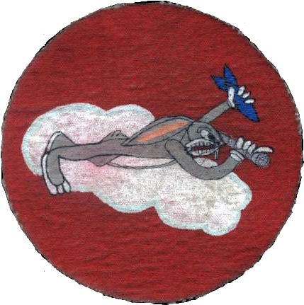
 | |
AAF Bombardier School patch, 1943 |
Established by the United States Army Air Corps in 1942 as Carlsbad Army Airfield, the facility was activated on 12 October 1942. Assigned to United States Army Air Forces West Coast Training Center (later Western Training Command) as a advanced (level 3) twin-engine training airfield. Began training flying cadets under the 940th Two-Engine Flying Training Detachment. Had a local axillary airfield for emergency and overflow landings.
The twin-engine school was replaced by Bombardier's School in mid-1942. Bombardier school lasted from 12 to 18 weeks during which a student dropped approximately 160 bombs, both in daytime and at night. Precise records were maintained of his hits and misses; the elimination rate was 12%. Upon graduation, a bombardier was transferred to an operational Second or Third Air Force training unit to join a crew being trained for overseas duty. The bombardier trainer used was the Beech AT-11 Kansan.
Inactivated on 30 September 1945 at the end of World War II and turned over to the Army Corps of Engineers. Eventually discharged to the War Assets Administration (WAA) and became a civil airport.
The above content comes from Wikipedia and is published under free licenses – click here to read more.
Location & QuickFacts
| FAA Information Effective: | 2008-09-25 |
| Airport Identifier: | CNM |
| Airport Status: | Operational |
| Longitude/Latitude: | 104-15-47.8000W/32-20-14.9000N
-104.263278/32.337472 (Estimated) |
| Elevation: | 3295 ft / 1004.32 m (Surveyed) |
| Land: | 1980 acres |
| From nearest city: | 5 nautical miles SW of Carlsbad, NM |
| Location: | Eddy County, NM |
| Magnetic Variation: | 10E (1985) |
Owner & Manager
| Ownership: | Publicly owned |
| Owner: | City Of Carlsbad |
| Address: | 101 North Halagueno St
Carlsbad, NM 88220 |
| Phone number: | 575-887-1191 |
| Manager: | George West
ACTING. |
| Address: | 101 North Halagueno St
Carlsbad, NM 88220 |
| Phone number: | 575-887-3060 |
Airport Operations and Facilities
| Airport Use: | Open to public |
| Wind indicator: | Yes |
| Segmented Circle: | Yes |
| Control Tower: | No |
| Lighting Schedule: | DUSK-DAWN
MIRL RYS 03/21, 08/26 & 14R/32L PRESET LOW INTST; TO INCR INTST & ACTVT MALSR RY 03 - CTAF. |
| Beacon Color: | Clear-Green (lighted land airport) |
| Landing fee charge: | No |
| Sectional chart: | Albuquerque |
| Region: | ASW - Southwest |
| Boundary ARTCC: | ZAB - Albuquerque |
| Tie-in FSS: | ABQ - Albuquerque |
| FSS on Airport: | No |
| FSS Toll Free: | 1-800-WX-BRIEF |
| NOTAMs Facility: | CNM (NOTAM-d service avaliable) |
| Certification type/date: | II A S 07/199
24 HRS PPR FOR ACR OPNS WITH MORE THAN 30 PSGR SEATS CTC AMGR 575-887-1191. RY 14L/32R NOT AVBL FOR ACR OPNS WITH MORE THAN 9 PASSENGER SEATS. |
| Federal Agreements: | NGPSY |
Airport Communications
| CTAF: | 122.950 |
| Unicom: | 122.950 |
Airport Services
| Fuel available: | 100LLA1+
FOR FUEL AFT HRS, SAT AND SUN CALL 575-887-1500. |
| Bottled Oxygen: | NONE |
| Bulk Oxygen: | NONE |
Runway Information
Runway 03/21
| Dimension: | 7854 x 150 ft / 2393.9 x 45.7 m |
| Surface: | ASPH, Good Condition |
| Surface Treatment: | Porous Friction Course |
| Weight Limit: | Single wheel: 62000 lbs.
Dual wheel: 88000 lbs.
Dual tandem wheel: 140000 lbs. |
| Edge Lights: | Medium |
| |
Runway 03 |
Runway 21 |
| Longitude: | 104-16-27.3291W | 104-15-23.5982W |
| Latitude: | 32-19-21.5383N | 32-20-17.2965N |
| Elevation: | 3294.00 ft | 3247.00 ft |
| Alignment: | 44 | 127 |
| ILS Type: | ILS
| |
| Traffic Pattern: | Left | Left |
| Markings: | Precision instrument, Good Condition | Non-precision instrument, Good Condition |
| Crossing Height: | 0.00 ft | 58.00 ft |
| VASI: | | 4-box on left side |
| Visual Glide Angle: | 0.00° | 3.00° |
| Approach lights: | MALSR | |
| Runway End Identifier: | No | |
| Obstruction: | 24 ft road, 1080.0 ft from runway, 623 ft left of centerline, 36:1 slope to clear | 14 ft road, 388.0 ft from runway, 514 ft left of centerline, 13:1 slope to clear |
| Decleard distances: | Take off run available 7854.00 ft
Take off distance available 7854.00 ft
Actual stop distance available 7854.00 ft
Landing distance available 7854.00 ft
| Take off run available 7854.00 ft
Take off distance available 7854.00 ft
Actual stop distance available 7854.00 ft
Landing distance available 7854.00 ft
|
|
Runway 08/26
| Dimension: | 5333 x 75 ft / 1625.5 x 22.9 m |
| Surface: | ASPH, Fair Condition |
| Weight Limit: | Single wheel: 19000 lbs. |
| Edge Lights: | Medium |
| |
Runway 08 |
Runway 26 |
| Longitude: | 104-16-14.6095W | 104-15-12.4492W |
| Latitude: | 32-20-32.2635N | 32-20-32.2467N |
| Elevation: | 3270.00 ft | 3238.00 ft |
| Alignment: | 90 | 127 |
| Traffic Pattern: | Left | Left |
| Markings: | Basic, Fair Condition | Basic, Fair Condition |
| Obstruction: | 15 ft road, 310.0 ft from runway, 7:1 slope to clear | 4 ft fence, 200.0 ft from runway, 125 ft right of centerline |
| Decleard distances: | Take off run available 5333.00 ft
Take off distance available 5333.00 ft
Actual stop distance available 5333.00 ft
Landing distance available 5333.00 ft
| Take off run available 5333.00 ft
Take off distance available 5333.00 ft
Actual stop distance available 5333.00 ft
Landing distance available 5333.00 ft
|
|
Runway 14L/32R
| Dimension: | 4615 x 150 ft / 1406.7 x 45.7 m |
| Surface: | ASPH, Poor Condition |
| Weight Limit: | Single wheel: 8000 lbs.
Dual wheel: 12500 lbs. |
| |
Runway 14L |
Runway 32R |
| Longitude: | 104-15-36.2949W | 104-15-14.6029W |
| Latitude: | 32-21-06.6643N | 32-20-24.8811N |
| Elevation: | 3240.00 ft | 3242.00 ft |
| Alignment: | 127 | 127 |
| Traffic Pattern: | Left | Right |
| Markings: | Basic, Poor Condition
RY 14L/32R YELLOW MKGS VISIBLE; WHITE MKGS FADED. | Basic, Poor Condition |
| Displaced threshold: | 0.00 ft | 616.00 ft |
| Obstruction: | , 50:1 slope to clear | 15 ft road, 230.0 ft from runway, 150 ft right of centerline
APCH RATIO 38:1 FM DSPLCD THLD. |
| Decleard distances: | Take off run available 4615.00 ft
Take off distance available 4615.00 ft
Actual stop distance available 4615.00 ft
Landing distance available 4615.00 ft
| Take off run available 4615.00 ft
Take off distance available 4615.00 ft
Actual stop distance available 4615.00 ft
Landing distance available 3999.00 ft
|
|
Runway 14R/32L
| Dimension: | 5839 x 100 ft / 1779.7 x 30.5 m |
| Surface: | ASPH, Fair Condition |
| Weight Limit: | Single wheel: 30000 lbs.
Dual wheel: 45000 lbs. |
| Edge Lights: | Medium |
| |
Runway 14R |
Runway 32L |
| Longitude: | 104-16-15.0943W | 104-15-45.3056W |
| Latitude: | 32-20-34.4083N | 32-19-42.4760N |
| Elevation: | 3269.00 ft | 3267.00 ft |
| Alignment: | 127 | 127 |
| Traffic Pattern: | Right | Left |
| Markings: | Non-precision instrument, Good Condition | Non-precision instrument, Good Condition |
| Crossing Height: | 69.00 ft | 0.00 ft |
| Displaced threshold: | 0.00 ft | 385.00 ft |
| VASI: | 4-light PAPI on left side | 4-light PAPI on left side |
| Visual Glide Angle: | 4.00° | 0.00° |
| Obstruction: | 7 ft road, 300.0 ft from runway, 150 ft left of centerline, 14:1 slope to clear | 15 ft road, 672.0 ft from runway, 318 ft right of centerline, 31:1 slope to clear
APCH SLOPE 50:1 FM DSPLCD THLD. |
| Decleard distances: | Take off run available 5839.00 ft
Take off distance available 5839.00 ft
Actual stop distance available 5839.00 ft
Landing distance available 5839.00 ft
| Take off run available 5839.00 ft
Take off distance available 5839.00 ft
Actual stop distance available 5839.00 ft
Landing distance available 5454.00 ft
|
|
Radio Navigation Aids
| ID |
Type |
Name |
Ch |
Freq |
Var |
Dist |
| ATS | NDB | Artesia | | 414.00 | 09E | 32.6 nm |
| CNM | VORTAC | Carlsbad | 110X | 116.30 | 12E | 5.2 nm |
Remarks
Images and information placed above are from
http://www.airport-data.com/airport/CNM/
We thank them for the data!
| General Info
|
| Country |
United States
|
| State |
NEW MEXICO
|
| FAA ID |
CNM
|
| Latitude |
32-20-14.900N
|
| Longitude |
104-15-47.800W
|
| Elevation |
3295 feet
|
| Near City |
CARLSBAD
|
We don't guarantee the information is fresh and accurate. The data may
be wrong or outdated.
For more up-to-date information please refer to other sources.
|
|