 |
|
| Woodbine Municipal Airport |
| IATA: none – ICAO: KOBI – FAA LID: OBI |
| Summary |
| Airport type |
Public use |
| Owner |
Woodbine Port Authority |
| Serves |
Woodbine, New Jersey |
| Elevation AMSL |
42 ft / 13 m |
| Coordinates |
39°13′09″N 074°47′41″W / 39.21917°N 74.79472°W / 39.21917; -74.79472 |
| Runways |
| Direction |
Length |
Surface |
| ft |
m |
| 01/19 |
3,304 |
1,007 |
Asphalt |
| 13/31 |
3,073 |
937 |
Asphalt |
| Statistics (2008) |
| Aircraft operations |
12,375 |
| Based aircraft |
77 |
| Source: Federal Aviation Administration |
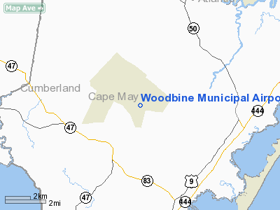
Woodbine Municipal Airport (ICAO: KOBI, FAA LID: OBI, formerly 1N4) is a public-use airport located two nautical miles (4 km) southeast of the central business district of Woodbine, in Cape May County, New Jersey, United States. It is publicly owned by the Woodbine Port Authority.
Facilities and aircraft
Woodbine Municipal Airport covers an area of 700 acres (283 ha) at an elevation of 42 feet (13 m) above mean sea level. It has two asphalt paved runways: 1/19 is 3,304 by 75 feet (1,007 x 23 m) and 13/31 is 3,073 by 75 feet (937 x 23 m).
For the 12-month period ending August 18, 2008, the airport had 12,375 aircraft operations, an average of 34 per day, all of which were general aviation, with a few ultralights. At that time there were 77 aircraft based at this airport: 94% single-engine, 3% glider, 3% ultralight, and 1 jet.
The above content comes from Wikipedia and is published under free licenses – click here to read more.
Location & QuickFacts
| FAA Information Effective: | 2008-09-25 |
| Airport Identifier: | OBI |
| Airport Status: | Operational |
| Longitude/Latitude: | 074-47-41.1540W/39-13-08.9400N
-74.794765/39.219150 (Estimated) |
| Elevation: | 42 ft / 12.80 m (Surveyed) |
| Land: | 700 acres |
| From nearest city: | 2 nautical miles SE of Woodbine, NJ |
| Location: | Cape May County, NJ |
| Magnetic Variation: | 12W (2000) |
Owner & Manager
| Ownership: | Publicly owned |
| Owner: | Woodbine Port Authority |
| Address: | 660 Henry Decinque Blvd
Woodbine, NJ 08270 |
| Phone number: | 609-861-1300 |
| Manager: | William Pikolycky |
| Address: | 660 Henry Decinque Blvd
Woodbine, NJ 08270 |
| Phone number: | 609-861-1300 |
Airport Operations and Facilities
| Airport Use: | Open to public |
| Wind indicator: | Yes |
| Segmented Circle: | No |
| Control Tower: | No |
| Lighting Schedule: | DUSK-DAWN
ACTVT MIRL RYS 13/31 & 01/19 - CTAF. |
| Beacon Color: | Clear-Green (lighted land airport) |
| Landing fee charge: | No |
| Sectional chart: | Washington |
| Region: | AEA - Eastern |
| Boundary ARTCC: | ZDC - Washington |
| Tie-in FSS: | MIV - Millville |
| FSS on Airport: | No |
| FSS Toll Free: | 1-800-WX-BRIEF |
| NOTAMs Facility: | MIV (NOTAM-d service avaliable) |
| Federal Agreements: | NGRY3 |
Airport Communications
| CTAF: | 123.050 |
| Unicom: | 123.050
AUTOMATED UNICOM. |
Airport Services
| Fuel available: | 100LL |
| Airframe Repair: | MAJOR |
| Power Plant Repair: | MAJOR |
| Bottled Oxygen: | NONE |
| Bulk Oxygen: | NONE |
Runway Information
Runway 01/19
| Dimension: | 3304 x 75 ft / 1007.1 x 22.9 m |
| Surface: | ASPH, Good Condition |
| Weight Limit: | Single wheel: 45000 lbs.
Dual wheel: 60000 lbs.
Dual tandem wheel: 120000 lbs. |
| Edge Lights: | Medium |
| |
Runway 01 |
Runway 19 |
| Longitude: | 074-47-48.6320W | 074-47-48.6050W |
| Latitude: | 39-12-50.6360N | 39-13-23.2990N |
| Elevation: | 25.00 ft | 42.00 ft |
| Alignment: | 0 | 127 |
| Traffic Pattern: | Left | Left |
| Markings: | Non-precision instrument, Good Condition | Non-precision instrument, Good Condition |
| Crossing Height: | 0.00 ft | 21.00 ft |
| VASI: | | 2-light PAPI on left side |
| Visual Glide Angle: | 0.00° | 3.70° |
| Runway End Identifier: | | Yes |
| Obstruction: | 50 ft trees, 536.0 ft from runway, 288 ft right of centerline, 6:1 slope to clear
+13 FT BRUSH, 44 FT FM THLD, 127 FT L. | 55 ft trees, 367.0 ft from runway, 270 ft right of centerline, 3:1 slope to clear
+19 FT TREES, 7 FT FM THLD, 189 FT R. |
|
Runway 13/31
| Dimension: | 3073 x 75 ft / 936.7 x 22.9 m |
| Surface: | ASPH, Good Condition |
| Weight Limit: | Single wheel: 35000 lbs.
Dual wheel: 50000 lbs.
Dual tandem wheel: 110000 lbs. |
| Edge Lights: | Medium |
| |
Runway 13 |
Runway 31 |
| Longitude: | 074-47-50.0330W | 074-47-16.2260W |
| Latitude: | 39-13-18.6670N | 39-13-03.4540N |
| Elevation: | 40.00 ft | 36.00 ft |
| Alignment: | 120 | 127 |
| Traffic Pattern: | Left | Left |
| Markings: | Basic, Fair Condition | Basic, Fair Condition |
| Crossing Height: | 20.00 ft | 25.00 ft |
| VASI: | 2-light PAPI on left side | 2-light PAPI on right side |
| Visual Glide Angle: | 3.00° | 3.50° |
| Runway End Identifier: | | Yes |
| Obstruction: | 25 ft tree, 381.0 ft from runway, 93 ft left of centerline, 7:1 slope to clear | 12 ft tree, 203.0 ft from runway, 81 ft right of centerline
+16 FT BRUSH, 92 FT FM THLD, 85 FT L. |
|
Radio Navigation Aids
| ID |
Type |
Name |
Ch |
Freq |
Var |
Dist |
| RNB | NDB | Rainbow | | 363.00 | 11W | 19.8 nm |
| DOV | TACAN | Dover | 037X | | 09W | 31.8 nm |
| ATR | VOR/DME | Waterloo | 073X | 112.60 | 09W | 31.4 nm |
| SIE | VORTAC | Sea Isle | 095X | 114.80 | 09W | 7.4 nm |
| ACY | VORTAC | Atlantic City | 023X | 108.60 | 10W | 17.5 nm |
| VCN | VORTAC | Cedar Lake | 099X | 115.20 | 10W | 20.8 nm |
| ENO | VORTAC | Smyrna | 051X | 111.40 | 09W | 33.6 nm |
| OOD | VORTAC | Woodstown | 075X | 112.80 | 10W | 34.4 nm |
| CYN | VORTAC | Coyle | 081X | 113.40 | 10W | 39.7 nm |
| DQO | VORTAC | Dupont | 087X | 114.00 | 10W | 46.7 nm |
| GXU | VORTAC | Mc Guire | 043X | 110.60 | 11W | 48.4 nm |
| PHL | VOT | Philadelphia Intl | | 109.80 | | 44.4 nm |
Remarks
- BANNER TOWING OPNS MEMORIAL DAY THRU LABOR DAY.
- OCNL WEEKEND GLIDER OPNS ALL RWYS.
- GCO AVBL ON FREQ 121.725 THRU ISLIP FSS.
Images and information placed above are from
http://www.airport-data.com/airport/OBI/
We thank them for the data!
| General Info
|
| Country |
United States
|
| State |
OHIO
|
| FAA ID |
7OH3
|
| Latitude |
40-21-10.219N
|
| Longitude |
083-03-03.672W
|
| Elevation |
952 feet
|
| Near City |
DELAWARE
|
We don't guarantee the information is fresh and accurate. The data may
be wrong or outdated.
For more up-to-date information please refer to other sources.
|
|


