|
 |
|
||||
|
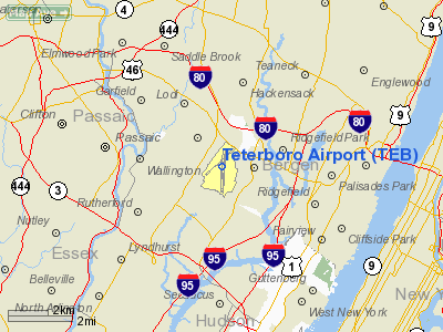
FAA diagram of Teterboro Airport (TEB) Teterboro Airport (IATA: TEB, ICAO: KTEB, FAA LID: TEB) is a general aviation relief airport located in the Boroughs of Teterboro, Moonachie, and Hasbrouck Heights in Bergen County, New Jersey, United States. It is owned and operated by the Port Authority of New York and New Jersey. The airport is 12 miles (19 km) from midtown Manhattan in the New Jersey Meadowlands, which makes it very popular for private and corporate aircraft. The airport takes up almost all of Teterboro and consists of 827 acres (3.35 km): 90 acres (0.36 km) for aircraft hangar and offices, 408 acres (1.65 km) for aeronautical use and runways, and 329 acres (1.33 km) undeveloped. The airport has more than 1,137 employees, of whom more than 90% are full time. In April 2009, the FAA reported that the airport had the third highest rate of wildlife strikes of any airport in the United States based on takeoffs and landings (43 per 100,000). HistoryTeterboro Airport is the oldest operating airport in the New York City area. Walter C. Teter (1863–1929) acquired the property in 1917. North American Aviation operated a manufacturing plant on the site during World War I. After the war, the airport served as a base of operations for Anthony Fokker, the Dutch aircraft designer. The first flight from the present airport site was made in 1919. In 1926 Colonial Air Transport at Teterboro was the first private company to deliver mail by air. During World War II, the United States Army operated the airport. The Port Authority of NY & NJ purchased it on April 1, 1949, from Fred L. Wehran, a private owner and later leased it to Pan American World Airways (and its successor organization Johnson Controls) for 30 years until December 1, 2000, when the Port Authority assumed full responsibility for the operation of Teterboro. In January 1954, Arthur Godfrey buzzed the Teterboro control tower with his Douglas DC-3, resulting in the suspension of his license. In 2003, U.S. Congressman Steve Rothman helped to authorize a federal bill to retain a ban on aircraft exceeding a weight of 100,000 pounds (45 t) from taking off from Teterboro because of excessive noise levels in the surrounding residential communities. On October 11, 2006, a small general aviation plane, a Cirrus SR20, took off from Teterboro, crashed in New York City at 2:42 pm local time. The aircraft struck the north side of an apartment building on the Upper East Side of Manhattan; it caused a fire in two apartments on the 40th and 41st floors, which was extinguished within one hour. The aircraft was owned and piloted by New York Yankees pitcher Cory Lidle, who died in the accident along with his flight instructor. As a result of this accident the FAA established restrictions for flying up the East River. Two midair collisions have occurred over the Hudson River involving aircraft that departed from Teterboro, one in 1976, and one in 2009. As a result of the latest accident the FAA came up with new guidelines for pilots flying the Hudson River including mandatory reporting points and separating slower helicopter traffic from faster fixed wing traffic via assigned altitude blocks. A Beechcraft Baron crashed while attempting to land around 3:00 a.m. on August 21, 2009. Both the pilot and passenger survived but sustained burns requiring the attention of Saint Barnabas Medical Center's burn unit, the only one in the state of New Jersey. The plane was believed to have originated at Reading, PA, and was carrying blood samples for Quest Diagnostics, which has a lab on property adjacent to Teterboro Airport. FacilitiesBuildingsNineteen hangars on the airport have a total area of approximately 412,000 square feet. Two large office buildings centrally located, one at 90 Moonachie Ave and the other on Fred Wheran Drive, which houses the Department of Homeland Security. Both buildings occupy a total area of 133,418 square feet. Additional office and shop space with a total area of 165,611 square feet (15,385.8 m). An operations building, maintenance facility and two fuel farms. The airport contains the Aviation Hall of Fame of New Jersey. Control towerThe control tower was constructed on the east side of the airport by the FAA and went into operation on October 29, 1975. The original control tower is not operational but is still part of the original wooden Atlantic Aviation hanger on Industrial Avenue. It is on the northeast corner of the hanger. RunwaysRunway 6-24 is 6,013 feet (1,833 m) long and 150 feet (46 m) wide, equipped with High Intensity Runway Lights (HIRL). Runway 6 and Runway 1 approaches both have Instrument Landing System (ILS) and a Medium Approach Lighting System-R (MALS-R). Runway 24 approach is equipped with both a Precision Approach Path Indicator (PAPI) and Runway End Identification Lights (REIL) systems. Runway 6-24 underwent complete overlay and grooving in 1987. Runway 1-19 is 7,000 feet (2,100 m) long and 150 feet (46 m) wide, equipped with HIRL. Both runways 1 and 19 are equipped with REIL systems. Runway 1 approach is equipped with a VASI system. Runway 19 approach has an ILS and a Precision Approach Path Indicator (PAPI). Runway 1-19 was overlaid and grooved in the summer of 2000, and included the installation of centerline and touchdown zone lighting. Runway 19 is the preferred runway for noise abatement procedures. TaxiwaysApproximately 4.2 miles (6.8 km) of taxiways exist on the airport. Most are 60 feet (18 m) wide and are equipped with centerline lighting systems. AircraftFor the 12-month period ending December 31, 2006, the airport had 199,199 aircraft operations, an average of 545 per day: 62% general aviation, 38% air taxi, <1% military and <1% scheduled commercial. At that time there were 171 aircraft based at this airport: 22% single-engine, 13% multi-engine, 56% jet and 9% helicopter. OtherThe Aviation Hall of Fame of New Jersey is located on the airport grounds. Founded in 1972, it is the first state aviation hall of fame in the nation, honoring the men and women who brought outstanding aeronautical achievements to the state. The recently expanded museum offers visitors an opportunity to view historic air and space equipment and artifacts, photographs, fine art and an extensive model collection. The Library has more than 4,000 volumes and hundreds of aviation video tapes. Public transportationTeterboro Airport can be reached from the Port Authority Bus Terminal in Midtown Manhattan on New Jersey Transit bus routes 161 (regular service), 165 (limited weekday service) and 144 (peak periods weekdays). The Teterboro (NJT station) is the closest rail station along New Jersey Transit's Pascack Valley Line, but the Wood-Ridge station is also close to the southwest of the airport. The above content comes from Wikipedia and is published under free licenses – click here to read more.
Location & QuickFacts
Owner & Manager
Airport Operations and Facilities
Airport Services
Runway InformationRunway 01/19
Runway 06/24
Radio Navigation Aids
Remarks
Images and information placed above are from We thank them for the data!
We don't guarantee the information is fresh and accurate. The data may
be wrong or outdated.
|
|||||||||||||||||||||||||||||||||||||||||||||||||||||||||||||||||||||||||||||||||||||||||||||||||||||||||||||||||||||||||||||||||||||||||||||||||||||||||||||||||||||||||||||||||||||||||||||||||||||||||||||||||||||||||||||||||||||||||||||||||||||||||||||||||||||||||||||||||||||||||||||||||||||||||||||||||||||||||||||||||||||||||||||||||||||||||||||||||||||||||||||||||||||||||||||||||||||||||||||||||||||||||||||||||||||||||||||||||||||||||||||||||||||||||||||||||||||||||||||||||||||||||||||||||||||||||||||||||||||||||

 |
|
Copyright 2004-2024 © by Airports-Worldwide.com, Vyshenskoho st. 36, Lviv 79010, Ukraine Legal Disclaimer |