 |
|
| Sky Manor Airport |
| IATA: none – ICAO: none – FAA LID: N40 |
| Summary |
| Airport type |
Public |
| Operator |
Sky Manor Airport Partners, LLC |
| Location |
Pittstown, New Jersey |
| Elevation AMSL |
560 ft / 170.7 m |
| Coordinates |
40°33′59″N 074°58′43″W / 40.56639°N 74.97861°W / 40.56639; -74.97861Coordinates: 40°33′59″N 074°58′43″W / 40.56639°N 74.97861°W / 40.56639; -74.97861 |
| Runways |
| Direction |
Length |
Surface |
| ft |
m |
| 7/25 |
2,900 |
884 |
Asphalt |
| Statistics (2010) |
| Aircraft operations |
22,111 |
| Based aircraft |
105 |
| Source: Federal Aviation Administration |
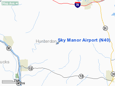
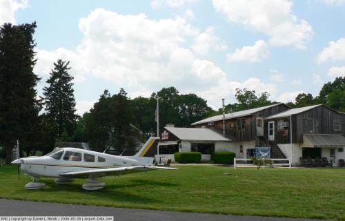
Sky Manor Airport (FAA LID: N40) is a public airport located 2 miles (3.2 km) southwest of Pittstown, serving Hunterdon County, New Jersey, USA. The airport has one runway and is mostly used for general aviation. History
The airport was owned by the Tice family for many years, who operated Sky Manor airport from 1963–1971. The airport was sold to the Kouba family in 1963. Later, it was bought by the Teri family in 1971. The Teri family sold it to Kent Linn in 1978. The current owner and operator of the airport is Sky Manor Airport Partners,LLC which acquired the property in November of 2008.
Facilities
Sky Manor Airport has one runway:
- Runway 7/25: 2,900 x 50 ft (884 x 15 m). Surface: Asphalt
The above content comes from Wikipedia and is published under free licenses – click here to read more.
 |
(Click on the photo to enlarge) |
Location & QuickFacts
| FAA Information Effective: | 2008-09-25 |
| Airport Identifier: | N40 |
| Airport Status: | Operational |
| Longitude/Latitude: | 074-58-43.1090W/40-33-58.5680N
-74.978641/40.566269 (Estimated) |
| Elevation: | 560 ft / 170.69 m (Estimated) |
| Land: | 60 acres |
| From nearest city: | 2 nautical miles SW of Pittstown, NJ |
| Location: | Hunterdon County, NJ |
| Magnetic Variation: | 10W (1965) |
Owner & Manager
| Ownership: | Privately owned |
| Owner: | Kent Linn |
| Address: | 48 Sky Manor Rd.
Pittstown, NJ 08867 |
| Phone number: | 908-996-4200 |
| Manager: | Kent Linn |
| Address: | 48 Sky Manor Rd.
Pittstown, NJ 08867 |
| Phone number: | 908-996-4200 |
Airport Operations and Facilities
| Airport Use: | Open to public |
| Wind indicator: | Yes |
| Segmented Circle: | No |
| Control Tower: | No |
| Lighting Schedule: | RDO-CTL
ACTVT MIRL RY 07/25; REIL RYS 07 & 25; PAPI RYS 07 & 25 & TWY LGTS - CTAF. |
| Landing fee charge: | No |
| Sectional chart: | New York |
| Region: | AEA - Eastern |
| Boundary ARTCC: | ZNY - New York |
| Tie-in FSS: | MIV - Millville |
| FSS on Airport: | No |
| FSS Toll Free: | 1-800-WX-BRIEF |
| NOTAMs Facility: | MIV (NOTAM-d service avaliable) |
| Federal Agreements: | N |
Airport Communications
| CTAF: | 122.975 |
| Unicom: | 122.975 |
Airport Services
| Fuel available: | 100LL |
| Airframe Repair: | MAJOR |
| Power Plant Repair: | MAJOR |
| Bottled Oxygen: | NONE |
| Bulk Oxygen: | NONE |
Runway Information
Runway 07/25
| Dimension: | 2900 x 50 ft / 883.9 x 15.2 m |
| Surface: | ASPH, Good Condition |
| Edge Lights: | Medium |
| |
Runway 07 |
Runway 25 |
| Longitude: | 074-59-00.7600W | 074-58-30.2580W |
| Latitude: | 40-33-48.8000N | 40-34-05.5520N |
| Elevation: | 548.00 ft | 558.00 ft |
| Alignment: | 54 | 127 |
| Traffic Pattern: | Left | Left |
| Markings: | Basic, Fair Condition | Basic, Fair Condition |
| Crossing Height: | 26.00 ft | 29.00 ft |
| Displaced threshold: | 878.00 ft | 0.00 ft |
| VASI: | 2-light PAPI on right side | 2-light PAPI on left side |
| Visual Glide Angle: | 4.00° | 4.00° |
| Runway End Identifier: | Yes | Yes |
| Obstruction: | 80 ft trees, 948.0 ft from runway, 360 ft right of centerline, 9:1 slope to clear
RY 07 APCH SLOPE 22:1 TO DSPLCD THLD. | 99 ft pline, 2070.0 ft from runway, 210 ft left of centerline, 18:1 slope to clear
13 FT T-HANGARS 80 FT FM THLD 215 FT R. |
|
Radio Navigation Aids
| ID |
Type |
Name |
Ch |
Freq |
Var |
Dist |
| EWR | FAN MARKER | Maryann | | | 11W | 37.0 nm |
| DYL | NDB | Doylestown | | 237.00 | 10W | 15.3 nm |
| UKT | NDB | Quakertown | | 208.00 | 12W | 16.9 nm |
| NXX | NDB | Willow Grove | | 388.00 | 12W | 23.9 nm |
| CAT | NDB | Chatham | | 254.00 | 11W | 27.1 nm |
| ING | NDB | Ambler | | 275.00 | 11W | 30.0 nm |
| LQX | NDB | Carbon | | 339.00 | 12W | 38.5 nm |
| NEL | NDB | Lakehurst | | 396.00 | 13W | 43.0 nm |
| PNJ | NDB | Paterson | | 347.00 | 12W | 44.1 nm |
| NXX | TACAN | Willow Grove | 061X | | 10W | 23.6 nm |
| NEL | TACAN | Lakehurst | 055X | | 11W | 42.8 nm |
| NEL | UHF/NDB | Lakehurst | | 274.80 | 13W | 43.0 nm |
| PNE | VOR | North Philadelphia | | 112.00 | 10W | 29.1 nm |
| SBJ | VOR/DME | Solberg | 076X | 112.90 | 10W | 10.9 nm |
| BWZ | VOR/DME | Broadway | 089X | 114.20 | 11W | 15.7 nm |
| CKZ | VOR/DME | Pennridge | 025Y | 108.85 | 12W | 17.7 nm |
| ARD | VOR/DME | Yardley | 019X | 108.20 | 10W | 19.1 nm |
| STW | VOR/DME | Stillwater | 033X | 109.60 | 11W | 26.3 nm |
| ETX | VOR/DME | East Texas | 039X | 110.20 | 09W | 32.2 nm |
| COL | VOR/DME | Colts Neck | 101X | 115.40 | 11W | 40.5 nm |
| TEB | VOR/DME | Teterboro | 021X | 108.40 | 11W | 45.1 nm |
| CRI | VOR/DME | Canarsie | 070X | 112.30 | 11W | 49.6 nm |
| FJC | VORTAC | Allentown | 122X | 117.50 | 10W | 23.8 nm |
| RBV | VORTAC | Robbinsville | 085X | 113.80 | 10W | 31.1 nm |
| PTW | VORTAC | Pottstown | 112X | 116.50 | 09W | 33.7 nm |
| SAX | VORTAC | Sparta | 104X | 115.70 | 11W | 36.2 nm |
| GXU | VORTAC | Mc Guire | 043X | 110.60 | 11W | 37.8 nm |
| PHL | VOT | Philadelphia Intl | | 109.80 | | 43.6 nm |
Remarks
- ULTRALIGHT ACTIVITY ON & INVOF ARPT.
- SELF-SERVE FUEL SYSTEM ON NORTH END OF TIE-DOWN RAMP.
- EXISTED PRIOR TO 1959.
Images and information placed above are from
http://www.airport-data.com/airport/N40/
We thank them for the data!
| General Info
|
| Country |
United States
|
| State |
NEW JERSEY
|
| FAA ID |
N40
|
| Latitude |
40-33-58.568N
|
| Longitude |
074-58-43.109W
|
| Elevation |
560 feet
|
| Near City |
PITTSTOWN
|
We don't guarantee the information is fresh and accurate. The data may
be wrong or outdated.
For more up-to-date information please refer to other sources.
|
|


