 |
|
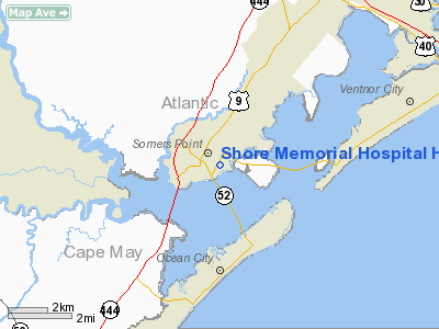
Shore Memorial Hospital Heliport |
Location & QuickFacts
| FAA Information Effective: | 2008-09-25 |
| Airport Identifier: | 87NJ |
| Airport Status: | Operational |
| Longitude/Latitude: | 074-35-38.5630W/39-18-50.4160N
-74.594045/39.314004 (Estimated) |
| Elevation: | 75 ft / 22.86 m (Estimated) |
| Land: | 0 acres |
| From nearest city: | 0 nautical miles N of Somers Point, NJ |
| Location: | Atlantic County, NJ |
| Magnetic Variation: | 12W (1985) |
Owner & Manager
| Ownership: | Privately owned |
| Owner: | Shore Memorial Hospital |
| Address: | New York Avenue
Somers Point, NJ 08244 |
| Phone number: | 609-653-3500 |
| Address: |
|
Airport Operations and Facilities
| Airport Use: | Private
MEDICAL USE. |
| Wind indicator: | Yes |
| Segmented Circle: | No |
| Control Tower: | No |
| Lighting Schedule: | PHONE REQ
FOR ROTG BCN PPR CALL - 609-653-3500. |
| Beacon Color: | Clear-Green-Yellow (heliport) |
| Landing fee charge: | No |
| Sectional chart: | Washington |
| Region: | AEA - Eastern |
| Boundary ARTCC: | ZDC - Washington |
| Tie-in FSS: | MIV - Millville |
| FSS on Airport: | No |
| FSS Toll Free: | 1-800-WX-BRIEF |
Runway Information
Helipad H1
| Dimension: | 44 x 41 ft / 13.4 x 12.5 m |
| Surface: | CONC,
ROOFTOP |
| |
Runway H1 |
Runway |
| Traffic Pattern: | Left | Left |
|
Radio Navigation Aids
| ID |
Type |
Name |
Ch |
Freq |
Var |
Dist |
| RNB | NDB | Rainbow | | 363.00 | 11W | 25.9 nm |
| NEL | NDB | Lakehurst | | 396.00 | 13W | 45.5 nm |
| DOV | TACAN | Dover | 037X | | 09W | 42.1 nm |
| NEL | TACAN | Lakehurst | 055X | | 11W | 44.9 nm |
| NEL | UHF/NDB | Lakehurst | | 274.80 | 13W | 45.5 nm |
| ATR | VOR/DME | Waterloo | 073X | 112.60 | 09W | 41.8 nm |
| ACY | VORTAC | Atlantic City | 023X | 108.60 | 10W | 8.6 nm |
| SIE | VORTAC | Sea Isle | 095X | 114.80 | 09W | 16.3 nm |
| VCN | VORTAC | Cedar Lake | 099X | 115.20 | 10W | 21.9 nm |
| CYN | VORTAC | Coyle | 081X | 113.40 | 10W | 31.2 nm |
| OOD | VORTAC | Woodstown | 075X | 112.80 | 10W | 38.2 nm |
| GXU | VORTAC | Mc Guire | 043X | 110.60 | 11W | 41.8 nm |
| ENO | VORTAC | Smyrna | 051X | 111.40 | 09W | 43.2 nm |
| PHL | VOT | Philadelphia Intl | | 109.80 | | 45.0 nm |
Remarks
- VFR USE ONLY, PENTHOUSE TO THE WEST IS OBSTRUCTION LIGHTED.
Images and information placed above are from
http://www.airport-data.com/airport/87NJ/
We thank them for the data!
| General Info
|
| Country |
United States
|
| State |
NEW JERSEY
|
| FAA ID |
87NJ
|
| Latitude |
39-18-50.416N
|
| Longitude |
074-35-38.563W
|
| Elevation |
75 feet
|
| Near City |
SOMERS POINT
|
We don't guarantee the information is fresh and accurate. The data may
be wrong or outdated.
For more up-to-date information please refer to other sources.
|
|


