 |
|
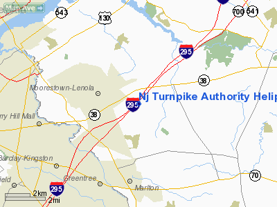
Nj Turnpike Authority Heliport |
Location & QuickFacts
| FAA Information Effective: | 2008-09-25 |
| Airport Identifier: | NJ97 |
| Airport Status: | Operational |
| Longitude/Latitude: | 074-55-10.1000W/39-57-20.0050N
-74.919472/39.955557 (Estimated) |
| Elevation: | 42 ft / 12.80 m (Estimated) |
| Land: | 0 acres |
| From nearest city: | 2 nautical miles NW of Mount Laurel, NJ |
| Location: | Burlington County, NJ |
| Magnetic Variation: | 12W (1990) |
Owner & Manager
| Ownership: | Privately owned |
| Owner: | Nj Turnpike Authority |
| Address: | Po Box 1121
New Brunswick, NJ 08903 |
| Phone number: | 908-247-0900 |
| Manager: | Robert F Dale |
| Address: |
|
Airport Operations and Facilities
| Airport Use: | Private |
| Segmented Circle: | No |
| Control Tower: | No |
| Lighting Schedule: | PHONE REQ
FOR PERIMETER & FLOOD LIGHT CALL 908-247-0900. |
| Sectional chart: | Washington |
| Region: | AEA - Eastern |
| Boundary ARTCC: | ZDC - Washington |
| Tie-in FSS: | MIV - Millville |
| FSS on Airport: | No |
| FSS Toll Free: | 1-800-WX-BRIEF |
Runway Information
Helipad H1
| Dimension: | 50 x 50 ft / 15.2 x 15.2 m |
| Surface: | ASPH, |
| |
Runway H1 |
Runway |
| Traffic Pattern: | Left | Left |
|
Radio Navigation Aids
| ID |
Type |
Name |
Ch |
Freq |
Var |
Dist |
| NXX | NDB | Willow Grove | | 388.00 | 12W | 17.5 nm |
| ING | NDB | Ambler | | 275.00 | 11W | 19.7 nm |
| DYL | NDB | Doylestown | | 237.00 | 10W | 24.7 nm |
| NEL | NDB | Lakehurst | | 396.00 | 13W | 27.4 nm |
| UKT | NDB | Quakertown | | 208.00 | 12W | 33.1 nm |
| RNB | NDB | Rainbow | | 363.00 | 11W | 33.8 nm |
| NXX | TACAN | Willow Grove | 061X | | 10W | 17.8 nm |
| NEL | TACAN | Lakehurst | 055X | | 11W | 26.5 nm |
| NEL | UHF/NDB | Lakehurst | | 274.80 | 13W | 27.4 nm |
| PNE | VOR | North Philadelphia | | 112.00 | 10W | 8.7 nm |
| ARD | VOR/DME | Yardley | 019X | 108.20 | 10W | 17.9 nm |
| CKZ | VOR/DME | Pennridge | 025Y | 108.85 | 12W | 31.2 nm |
| SBJ | VOR/DME | Solberg | 076X | 112.90 | 10W | 38.6 nm |
| COL | VOR/DME | Colts Neck | 101X | 115.40 | 11W | 41.0 nm |
| GXU | VORTAC | Mc Guire | 043X | 110.60 | 11W | 15.2 nm |
| CYN | VORTAC | Coyle | 081X | 113.40 | 10W | 24.0 nm |
| RBV | VORTAC | Robbinsville | 085X | 113.80 | 10W | 24.5 nm |
| VCN | VORTAC | Cedar Lake | 099X | 115.20 | 10W | 25.2 nm |
| OOD | VORTAC | Woodstown | 075X | 112.80 | 10W | 26.1 nm |
| PTW | VORTAC | Pottstown | 112X | 116.50 | 09W | 33.5 nm |
| ACY | VORTAC | Atlantic City | 023X | 108.60 | 10W | 34.0 nm |
| MXE | VORTAC | Modena | 079X | 113.20 | 09W | 34.7 nm |
| DQO | VORTAC | Dupont | 087X | 114.00 | 10W | 35.9 nm |
| PHL | VOT | Philadelphia Intl | | 109.80 | | 15.9 nm |
Remarks
- PRVDD AN ADDITIONAL ON-SITE INSPECTION IS CONDUCTED WHEN CONTRUCTION IS COMPLETE.
Images and information placed above are from
http://www.airport-data.com/airport/NJ97/
We thank them for the data!
| General Info
|
| Country |
United States
|
| State |
NEW JERSEY
|
| FAA ID |
NJ97
|
| Latitude |
39-57-20.005N
|
| Longitude |
074-55-10.100W
|
| Elevation |
42 feet
|
| Near City |
MOUNT LAUREL
|
We don't guarantee the information is fresh and accurate. The data may
be wrong or outdated.
For more up-to-date information please refer to other sources.
|
|


