|
|
- "MIV" redirects here. It is also the roman numeral for 1004.
| Millville Airport |
 |
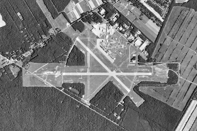
| 1991 USGS photo |
| IATA: MIV – ICAO: KMIV – FAA LID: MIV |
| Summary |
| Operator |
DRBA |
| Location |
Millville, New Jersey |
| Elevation AMSL |
85 ft / 25.9 m |
| Coordinates |
39°22′04″N 075°04′20″W / 39.36778°N 75.07222°W / 39.36778; -75.07222Coordinates: 39°22′04″N 075°04′20″W / 39.36778°N 75.07222°W / 39.36778; -75.07222 |
| Runways |
| Direction |
Length |
Surface |
| ft |
m |
| 10/28 |
6,002 |
1,829 |
Asphalt |
| 14/32 |
5,057 |
1,541 |
Concrete |
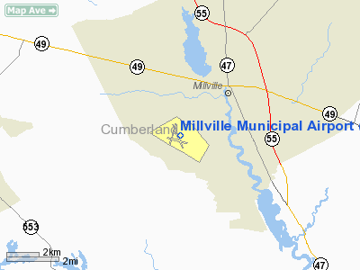
Millville Municipal Airport (IATA: MIV, ICAO: KMIV, FAA LID: MIV) is a public airport located three miles (5 km) southwest of the central business district of Millville, a city in Cumberland County, New Jersey, United States.
The airport is operated by the Delaware River and Bay Authority. It was dubbed "America's First Defense Airport" because of the nearly 1,500 pilots who trained in gunnery practice at the airport with the Republic P-47 "Thunderbolt" plane during World War II.
After the end of World War II, the buildings of Millville Airport accommodated returning veterans. By the end of the 1970s, these buildings were no longer of much use. Millville Airport is now used for general aviation. Dallas Airmotive exists at Millville. Facilities
Millville Municipal Airport covers 916 acres (371 ha) and has two runways:
- Runway 10/28: 6,002 x 150 ft. (1,829 x 46 m), Surface: Asphalt
- Runway 14/32: 5,057 x 150 ft. (1,541 x 46 m), Surface: Concrete
FBO's
Big Sky Aviation - CATS testing center and AV Fuel Dealer
History
The Millville Airport was dedicated on August 2, 1941 by local, state, and federal officials. The first contingent of Air Corps personnel arrived on 17 December 1942. In less than a year, construction of military base facilities began, and in January 1943, the Millville Army Air Field opened as a United States Army Air Forces gunnery school for fighter pilots. It was assigned to First Air Force.
Gunnery training began with Curtiss P-40 Warhawk aircraft, but after a few weeks, the P-40s were gone, and the Republic P-47 Thunderbolt ruled the skies over Cumberland County. During its three year existence, thousands of soldiers and civilians served here, with about 1,500 pilots receiving advanced fighter training in the Thunderbolt. The 361st Fighter Group trained at Millville during July and August 1943 prior to their deployment to Ninth Air Force in England. In 1944, the 135th Army Air Forces Base Unit (Flying) took control of the airfield.
On 30 October 1945 Millville AAF was inactivated and on 31 December the airfield was declared excess to the governments needs, and returned to the City of Millville through the War Assets Administration (WAA). Most of the airport buildings were converted to apartments for the many veterans returning from the war. The last of the apartments vanished in the early 1970s, and the airport soon became a hub of industry and aviation for Southern New Jersey.
The above content comes from Wikipedia and is published under free licenses – click here to read more.
Location & QuickFacts
| FAA Information Effective: | 2008-09-25 |
| Airport Identifier: | MIV |
| Airport Status: | Operational |
| Longitude/Latitude: | 075-04-20.0000W/39-22-04.1000N
-75.072222/39.367806 (Estimated) |
| Elevation: | 85 ft / 25.91 m (Surveyed) |
| Land: | 916 acres |
| From nearest city: | 3 nautical miles SW of Millville, NJ |
| Location: | Cumberland County, NJ |
| Magnetic Variation: | 11W (1985) |
Owner & Manager
| Ownership: | Publicly owned |
| Owner: | Drba-city Of Millville |
| Address: | 104 Leddon Street
Millville, NJ 08332 |
| Phone number: | 856-825-1244 |
| Manager: | J. David Mccarthy |
| Address: | Admin Bldg, 104 Leddon St
Millville, NJ 08332 |
| Phone number: | 856-825-1244 |
Airport Operations and Facilities
| Airport Use: | Open to public |
| Wind indicator: | Yes |
| Segmented Circle: | No |
| Control Tower: | No |
| Lighting Schedule: | DUSK-DAWN
ACTIVATE MIRL RYS 10/28 & 14/32, & MALSR RY 10 123.0. |
| Beacon Color: | Clear-Green (lighted land airport) |
| Landing fee charge: | No |
| Sectional chart: | Washington |
| Region: | AEA - Eastern |
| Boundary ARTCC: | ZDC - Washington |
| Tie-in FSS: | MIV - Millville
CTC MILLVILLE RADIO FOR AIRPORT ADVISORY SERVICE ON 123.65. |
| FSS on Airport: | No |
| FSS Toll Free: | 1-800-WX-BRIEF |
| NOTAMs Facility: | MIV (NOTAM-d service avaliable) |
| Federal Agreements: | NGRY3 |
Airport Communications
| CTAF: | 123.650 |
| Unicom: | 123.000 |
Airport Services
| Fuel available: | 100LLA
FUEL AVAILABLE, CONTACT ON 123.0 OR 131.1. |
| Airframe Repair: | MAJOR |
| Power Plant Repair: | MAJOR |
| Bottled Oxygen: | NONE |
| Bulk Oxygen: | NONE |
Runway Information
Runway 10/28
| Dimension: | 6002 x 150 ft / 1829.4 x 45.7 m |
| Surface: | ASPH, Good Condition |
| Weight Limit: | Single wheel: 40000 lbs.
Dual wheel: 65000 lbs.
Dual tandem wheel: 125000 lbs. |
| Edge Lights: | Medium |
| |
Runway 10 |
Runway 28 |
| Longitude: | 075-04-56.6501W | 075-03-40.2223W |
| Latitude: | 39-22-01.3468N | 39-22-01.3177N |
| Elevation: | 74.00 ft | 85.00 ft |
| Alignment: | 90 | 127 |
| ILS Type: | ILS
| |
| Traffic Pattern: | Left | Left |
| Markings: | Precision instrument, Good Condition | Precision instrument, Good Condition |
| Crossing Height: | 53.00 ft | 28.00 ft |
| VASI: | 4-light PAPI on left side | 4-light PAPI on left side |
| Visual Glide Angle: | 3.00° | 3.00° |
| Approach lights: | MALSR | |
| Runway End Identifier: | No | |
| Obstruction: | 65 ft trees, 2480.0 ft from runway, 170 ft left of centerline, 35:1 slope to clear | |
|
Runway 14/32
| Dimension: | 5057 x 150 ft / 1541.4 x 45.7 m |
| Surface: | CONC, Good Condition |
| Weight Limit: | Single wheel: 40000 lbs.
Dual wheel: 65000 lbs.
Dual tandem wheel: 125000 lbs. |
| Edge Lights: | Medium |
| |
Runway 14 |
Runway 32 |
| Longitude: | 075-04-44.5768W | 075-03-59.0655W |
| Latitude: | 39-22-25.0349N | 39-21-49.6791N |
| Elevation: | 81.00 ft | 82.00 ft |
| Alignment: | 127 | 127 |
| Traffic Pattern: | Left | Left |
| Markings: | Non-precision instrument, Good Condition | Basic, Good Condition |
| Crossing Height: | 48.00 ft | 36.00 ft |
| VASI: | 4-light PAPI on left side | 4-light PAPI on left side |
| Visual Glide Angle: | 3.00° | 3.00° |
| Obstruction: | 49 ft trees, 2160.0 ft from runway, 190 ft left of centerline, 40:1 slope to clear | 55 ft trees, 1335.0 ft from runway, 20:1 slope to clear |
|
Radio Navigation Aids
| ID |
Type |
Name |
Ch |
Freq |
Var |
Dist |
| RNB | NDB | Rainbow | | 363.00 | 11W | 4.2 nm |
| ING | NDB | Ambler | | 275.00 | 11W | 46.6 nm |
| APG | NDB | Aberdeen | | 349.00 | 11W | 49.0 nm |
| NXX | NDB | Willow Grove | | 388.00 | 12W | 49.5 nm |
| DOV | TACAN | Dover | 037X | | 09W | 23.2 nm |
| NXX | TACAN | Willow Grove | 061X | | 10W | 49.8 nm |
| PNE | VOR | North Philadelphia | | 112.00 | 10W | 43.0 nm |
| ATR | VOR/DME | Waterloo | 073X | 112.60 | 09W | 34.2 nm |
| VCN | VORTAC | Cedar Lake | 099X | 115.20 | 10W | 11.3 nm |
| OOD | VORTAC | Woodstown | 075X | 112.80 | 10W | 19.4 nm |
| SIE | VORTAC | Sea Isle | 095X | 114.80 | 09W | 20.7 nm |
| ENO | VORTAC | Smyrna | 051X | 111.40 | 09W | 22.2 nm |
| ACY | VORTAC | Atlantic City | 023X | 108.60 | 10W | 23.6 nm |
| DQO | VORTAC | Dupont | 087X | 114.00 | 10W | 31.0 nm |
| CYN | VORTAC | Coyle | 081X | 113.40 | 10W | 40.1 nm |
| MXE | VORTAC | Modena | 079X | 113.20 | 09W | 43.1 nm |
| GXU | VORTAC | Mc Guire | 043X | 110.60 | 11W | 44.4 nm |
| PHL | VOT | Philadelphia Intl | | 109.80 | | 31.2 nm |
Remarks
- DEER ON ARPT AFTER DUSK.
- ARPT CLSD TO ULTRA LIGHT ACFT EXCEPT PPR; PPR AVBL 856-825-1244 0800-1600 MON-FRI.
- TWY B RESTRICTED TO ACFT WITH WINGSPAN OVER 79 FT BETWEEN TWY C AND TWY E.
- PAEW WITHIN THE SAFETY AREAS OF ALL RYS ANDTWYS DAILY MAY THRU OCTOBER.
Images and information placed above are from
http://www.airport-data.com/airport/MIV/
We thank them for the data!
| General Info
|
| Country |
United States
|
| State |
NEW JERSEY
|
| FAA ID |
MIV
|
| Latitude |
39-22-04.100N
|
| Longitude |
075-04-20.000W
|
| Elevation |
85 feet
|
| Near City |
MILLVILLE
|
We don't guarantee the information is fresh and accurate. The data may
be wrong or outdated.
For more up-to-date information please refer to other sources.
|
|