 |
|
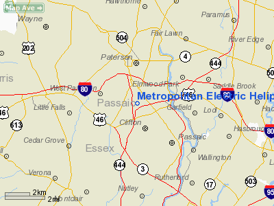
Metropolitan Electric Heliport |
Location & QuickFacts
| FAA Information Effective: | 2008-09-25 |
| Airport Identifier: | 47NJ |
| Airport Status: | Operational |
| Longitude/Latitude: | 074-09-49.5180W/40-53-14.3560N
-74.163755/40.887321 (Estimated) |
| Elevation: | 220 ft / 67.06 m (Estimated) |
| Land: | 0 acres |
| From nearest city: | 1 nautical miles SE of Clifton, NJ |
| Location: | Passaic County, NJ |
| Magnetic Variation: | 13W (1990) |
Owner & Manager
| Ownership: | Privately owned |
| Owner: | Pse & G Company |
| Address: | 80 Park Plaza T-12a
Newark, NJ 07101 |
| Phone number: | 201-430-6059 |
| Manager: | J. James |
| Address: | 80 Park Plaza T-19g
Newark, NJ 07101 |
| Phone number: | 201-430-6059 |
Airport Operations and Facilities
| Airport Use: | Private |
| Segmented Circle: | No |
| Control Tower: | No |
| Sectional chart: | New York |
| Region: | AEA - Eastern |
| Boundary ARTCC: | ZNY - New York |
| Tie-in FSS: | MIV - Millville |
| FSS on Airport: | No |
| FSS Toll Free: | 1-800-WX-BRIEF |
Runway Information
Helipad H1
| Dimension: | 85 x 85 ft / 25.9 x 25.9 m |
| Surface: | ASPH, |
| |
Runway H1 |
Runway |
| Traffic Pattern: | Left | Left |
|
Radio Navigation Aids
| ID |
Type |
Name |
Ch |
Freq |
Var |
Dist |
| EWR | FAN MARKER | Maryann | | | 11W | 11.1 nm |
| SKU | FAN MARKER | Stanwyck | | | 12W | 38.9 nm |
| PNJ | NDB | Paterson | | 347.00 | 12W | 3.6 nm |
| CAT | NDB | Chatham | | 254.00 | 11W | 15.0 nm |
| OGY | NDB | Bridge | | 414.00 | 12W | 23.1 nm |
| SW | NDB | Neely | | 335.00 | 14W | 36.1 nm |
| BBN | NDB | Babylon | | 275.00 | 14W | 37.8 nm |
| SKU | NDB | Stanwyck | | 261.00 | 12W | 38.9 nm |
| PO | NDB | Meier | | 403.00 | 12W | 42.3 nm |
| OP | NDB | Old Field Point Light | | 316.00 | 13W | 47.8 nm |
| TEB | VOR/DME | Teterboro | 021X | 108.40 | 11W | 5.2 nm |
| LGA | VOR/DME | La Guardia | 078X | 113.10 | 12W | 14.3 nm |
| CRI | VOR/DME | Canarsie | 070X | 112.30 | 11W | 20.6 nm |
| JFK | VOR/DME | Kennedy | 106X | 115.90 | 12W | 23.5 nm |
| BWZ | VOR/DME | Broadway | 089X | 114.20 | 11W | 30.4 nm |
| SBJ | VOR/DME | Solberg | 076X | 112.90 | 10W | 32.1 nm |
| STW | VOR/DME | Stillwater | 033X | 109.60 | 11W | 32.7 nm |
| COL | VOR/DME | Colts Neck | 101X | 115.40 | 11W | 34.6 nm |
| CMK | VOR/DME | Carmel | 113X | 116.60 | 12W | 35.4 nm |
| HUO | VOR/DME | Huguenot | 108X | 116.10 | 11W | 36.9 nm |
| DPK | VOR/DME | Deer Park | 124X | 117.70 | 12W | 39.5 nm |
| IGN | VOR/DME | Kingston | 123X | 117.60 | 12W | 49.2 nm |
| BDR | VOR/DME | Bridgeport | 25X | 108.80 | 12W | 49.9 nm |
| SAX | VORTAC | Sparta | 104X | 115.70 | 11W | 20.2 nm |
| RBV | VORTAC | Robbinsville | 085X | 113.80 | 10W | 43.9 nm |
| JFK | VOT | Kennedy | | 115.10 | | 23.2 nm |
| ISP | VOT | Long Island Mac Arthur | | 109.40 | | 49.0 nm |
| BDR | VOT | Bridgeport | | 109.25 | | 49.9 nm |
Remarks
- PRVDD DALGT VFR; CONTACT THE MGR OF TETERBORO ATCT PRIOR TO OPNS; PILOTS OPERG OUT OF THIS FACILITY ARE BRIEFED ON WHICH ALTITUDES ARE TO BE USED & THOSE TO BE AVOIDED.
Images and information placed above are from
http://www.airport-data.com/airport/47NJ/
We thank them for the data!
| General Info
|
| Country |
United States
|
| State |
NEW JERSEY
|
| FAA ID |
47NJ
|
| Latitude |
40-53-14.356N
|
| Longitude |
074-09-49.518W
|
| Elevation |
220 feet
|
| Near City |
CLIFTON
|
We don't guarantee the information is fresh and accurate. The data may
be wrong or outdated.
For more up-to-date information please refer to other sources.
|
|


