 |
|
Coordinates: 40°04′00.489″N 074°10′39.61″W / 40.0668025°N 74.1776694°W / 40.0668025; -74.1776694
| Lakewood Airport |
| IATA: none – ICAO: none – FAA LID: N12 |
| Summary |
| Airport type |
Public use |
| Owner |
Lakewood Township Airport Authority |
| Operator |
Bertram Albert |
| Serves |
Lakewood, New Jersey |
| Location |
Ocean County, New Jersey |
| Elevation AMSL |
43 ft / 13 m |
| Runways |
| Direction |
Length |
Surface |
| ft |
m |
| 6/24 |
2,912 |
888 |
Asphalt |
| Statistics (2008) |
| Aircraft operations |
15,226 |
| Based aircraft |
55 |
| Source: Federal Aviation Administration |
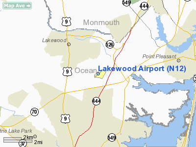
Lakewood Airport (FAA LID: N12) is a public-use airport located 3 miles (4.8 km) southeast of the central business district of Lakewood Township in Ocean County, New Jersey, United States. The airport is publicly owned. The airport is also home to the Pineland Composite Squadron of the Civil Air Patrol, unit number NER-NJ-096. For more info on Civil Air Patrol visit http://www.gocivilairpatrol.com
The above content comes from Wikipedia and is published under free licenses – click here to read more.
Location & QuickFacts
| FAA Information Effective: | 2008-09-25 |
| Airport Identifier: | N12 |
| Airport Status: | Operational |
| Longitude/Latitude: | 074-10-39.6100W/40-04-00.4890N
-74.177669/40.066803 (Estimated) |
| Elevation: | 43 ft / 13.11 m (Estimated) |
| Land: | 192 acres |
| From nearest city: | 3 nautical miles SE of Lakewood, NJ |
| Location: | Ocean County, NJ |
| Magnetic Variation: | 13W (2000) |
Owner & Manager
| Ownership: | Publicly owned |
| Owner: | Lakewood Township Airport Authority |
| Address: | 1900 Cedar Bridge Rd
Lakewood, NJ 08701 |
| Phone number: | 732-370-7781 |
| Manager: | Bertram Albert |
| Address: | 1900 Cedar Bridge Road
Lakewood, NJ 08701 |
| Phone number: | 732-370-7781 |
Airport Operations and Facilities
| Airport Use: | Open to public |
| Wind indicator: | Yes |
| Segmented Circle: | Yes |
| Control Tower: | No |
| Lighting Schedule: | DUSK-DAWN
ACTVT MIRL AND PAPI RYS 06 & 24 - CTAF. |
| Beacon Color: | Clear-Green (lighted land airport) |
| Landing fee charge: | No |
| Sectional chart: | New York |
| Region: | AEA - Eastern |
| Traffic Pattern Alt: | 800 ft |
| Boundary ARTCC: | ZNY - New York |
| Tie-in FSS: | MIV - Millville |
| FSS on Airport: | No |
| FSS Toll Free: | 1-800-WX-BRIEF |
| NOTAMs Facility: | MIV (NOTAM-d service avaliable) |
| Federal Agreements: | N |
Airport Communications
| CTAF: | 122.800 |
| Unicom: | 122.800
GCO AVBL ON FREQ 121.725 THRU ISLIP FSS. |
Airport Services
| Fuel available: | 100LL |
| Airframe Repair: | MAJOR |
| Power Plant Repair: | MAJOR |
| Bottled Oxygen: | NONE |
| Bulk Oxygen: | NONE |
Runway Information
Runway 06/24
| Dimension: | 2912 x 60 ft / 887.6 x 18.3 m |
| Surface: | ASPH, Good Condition |
| Weight Limit: | Single wheel: 25000 lbs. |
| Edge Lights: | Medium |
| |
Runway 06 |
Runway 24 |
| Longitude: | 074-10-53.3340W | 074-10-25.8910W |
| Latitude: | 40-03-50.7280N | 40-04-10.2410N |
| Elevation: | 43.00 ft | 33.00 ft |
| Alignment: | 47 | 127 |
| Traffic Pattern: | Left | Right |
| Markings: | Non-precision instrument, Poor Condition
MARKINGS FADED | Non-precision instrument, Poor Condition
MARKINGS FADED |
| Crossing Height: | 20.00 ft | 22.00 ft |
| Displaced threshold: | 264.00 ft | 247.00 ft |
| VASI: | 2-light PAPI on right side | 2-light PAPI on left side |
| Visual Glide Angle: | 3.50° | 3.25° |
| Obstruction: | 10 ft fence, 265.0 ft from runway, 6:1 slope to clear
RWY 06, APP RATIO 50:1 TO DISPL THLD. | 10 ft road, 200.0 ft from runway, 60 ft right of centerline
RY 24, APP RATIO 44:1 TO DISPL THLD.
RY 24 10 FT ROAD AT RY END 120 FT R CNTRLN. |
|
Radio Navigation Aids
| ID |
Type |
Name |
Ch |
Freq |
Var |
Dist |
| EWR | FAN MARKER | Maryann | | | 11W | 38.3 nm |
| NEL | NDB | Lakehurst | | 396.00 | 13W | 7.4 nm |
| OGY | NDB | Bridge | | 414.00 | 12W | 33.0 nm |
| CAT | NDB | Chatham | | 254.00 | 11W | 42.1 nm |
| NXX | NDB | Willow Grove | | 388.00 | 12W | 45.1 nm |
| DYL | NDB | Doylestown | | 237.00 | 10W | 46.3 nm |
| NEL | TACAN | Lakehurst | 055X | | 11W | 8.3 nm |
| NXX | TACAN | Willow Grove | 061X | | 10W | 45.2 nm |
| NEL | UHF/NDB | Lakehurst | | 274.80 | 13W | 7.4 nm |
| PNE | VOR | North Philadelphia | | 112.00 | 10W | 38.3 nm |
| COL | VOR/DME | Colts Neck | 101X | 115.40 | 11W | 14.7 nm |
| CRI | VOR/DME | Canarsie | 070X | 112.30 | 11W | 35.3 nm |
| ARD | VOR/DME | Yardley | 019X | 108.20 | 10W | 35.4 nm |
| JFK | VOR/DME | Kennedy | 106X | 115.90 | 12W | 38.8 nm |
| SBJ | VOR/DME | Solberg | 076X | 112.90 | 10W | 40.4 nm |
| LGA | VOR/DME | La Guardia | 078X | 113.10 | 12W | 45.5 nm |
| TEB | VOR/DME | Teterboro | 021X | 108.40 | 11W | 47.3 nm |
| RBV | VORTAC | Robbinsville | 085X | 113.80 | 10W | 16.7 nm |
| CYN | VORTAC | Coyle | 081X | 113.40 | 10W | 19.0 nm |
| GXU | VORTAC | Mc Guire | 043X | 110.60 | 11W | 19.6 nm |
| ACY | VORTAC | Atlantic City | 023X | 108.60 | 10W | 41.1 nm |
| VCN | VORTAC | Cedar Lake | 099X | 115.20 | 10W | 48.4 nm |
| JFK | VOT | Kennedy | | 115.10 | | 38.7 nm |
Remarks
- GCO AVBL ON FREQ 121.725 THRU NYAI FSS.
- HEAVY BANNER TOWING OPS SUMMER.
Images and information placed above are from
http://www.airport-data.com/airport/N12/
We thank them for the data!
| General Info
|
| Country |
United States
|
| State |
NEW JERSEY
|
| FAA ID |
N12
|
| Latitude |
40-04-00.417N
|
| Longitude |
074-10-39.510W
|
| Elevation |
43 feet
|
| Near City |
LAKEWOOD
|
We don't guarantee the information is fresh and accurate. The data may
be wrong or outdated.
For more up-to-date information please refer to other sources.
|
|


