 |
|
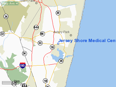
Jersey Shore Medical Center Heliport |
Location & QuickFacts
| FAA Information Effective: | 2008-09-25 |
| Airport Identifier: | NJ05 |
| Airport Status: | Operational |
| Longitude/Latitude: | 074-02-28.4970W/40-12-30.4060N
-74.041249/40.208446 (Estimated) |
| Elevation: | 40 ft / 12.19 m (Estimated) |
| Land: | 0 acres |
| From nearest city: | 1 nautical miles SW of Neptune, NJ |
| Location: | Monmouth County, NJ |
| Magnetic Variation: | 12W (1985) |
Owner & Manager
| Ownership: | Privately owned |
| Owner: | Jersey Shore Medical Cntr |
| Address: | Hospital Helistop
Neptune, NJ 07753 |
| Phone number: | 732-775-5500 |
| Manager: | Louis Mader |
| Address: | 1945 Route 33
Neptune, NJ 07754 |
| Phone number: | 732-776-4183 |
Airport Operations and Facilities
| Airport Use: | Private
MEDICAL USE. |
| Wind indicator: | Yes |
| Segmented Circle: | Yes |
| Control Tower: | No |
| Lighting Schedule: | DUSK-DAWN
FOR PERIMETER LGTS CALL 732-776-4183. |
| Beacon Color: | Clear-Green-Yellow (heliport) |
| Landing fee charge: | No |
| Sectional chart: | New York |
| Region: | AEA - Eastern |
| Boundary ARTCC: | ZNY - New York |
| Tie-in FSS: | MIV - Millville |
| FSS on Airport: | No |
| FSS Toll Free: | 1-800-WX-BRIEF |
Airport Services
| Airframe Repair: | NONE |
| Power Plant Repair: | NONE |
Runway Information
Helipad H1
| Dimension: | 110 x 110 ft / 33.5 x 33.5 m |
| Surface: | ASPH, |
| |
Runway H1 |
Runway |
| Traffic Pattern: | Left | Left |
|
Radio Navigation Aids
| ID |
Type |
Name |
Ch |
Freq |
Var |
Dist |
| EWR | FAN MARKER | Maryann | | | 11W | 30.5 nm |
| NEL | NDB | Lakehurst | | 396.00 | 13W | 16.7 nm |
| OGY | NDB | Bridge | | 414.00 | 12W | 22.8 nm |
| CAT | NDB | Chatham | | 254.00 | 11W | 36.6 nm |
| BBN | NDB | Babylon | | 275.00 | 14W | 41.0 nm |
| PNJ | NDB | Paterson | | 347.00 | 12W | 44.6 nm |
| NEL | TACAN | Lakehurst | 055X | | 11W | 17.7 nm |
| NEL | UHF/NDB | Lakehurst | | 274.80 | 13W | 16.7 nm |
| PNE | VOR | North Philadelphia | | 112.00 | 10W | 45.1 nm |
| COL | VOR/DME | Colts Neck | 101X | 115.40 | 11W | 8.2 nm |
| CRI | VOR/DME | Canarsie | 070X | 112.30 | 11W | 25.2 nm |
| JFK | VOR/DME | Kennedy | 106X | 115.90 | 12W | 28.3 nm |
| LGA | VOR/DME | La Guardia | 078X | 113.10 | 12W | 35.6 nm |
| TEB | VOR/DME | Teterboro | 021X | 108.40 | 11W | 38.5 nm |
| SBJ | VOR/DME | Solberg | 076X | 112.90 | 10W | 39.2 nm |
| ARD | VOR/DME | Yardley | 019X | 108.20 | 10W | 39.8 nm |
| DPK | VOR/DME | Deer Park | 124X | 117.70 | 12W | 48.6 nm |
| RBV | VORTAC | Robbinsville | 085X | 113.80 | 10W | 20.8 nm |
| GXU | VORTAC | Mc Guire | 043X | 110.60 | 11W | 28.2 nm |
| CYN | VORTAC | Coyle | 081X | 113.40 | 10W | 29.6 nm |
| JFK | VOT | Kennedy | | 115.10 | | 28.3 nm |
Images and information placed above are from
http://www.airport-data.com/airport/NJ05/
We thank them for the data!
| General Info
|
| Country |
United States
|
| State |
NEW JERSEY
|
| FAA ID |
NJ05
|
| Latitude |
40-12-30.406N
|
| Longitude |
074-02-28.497W
|
| Elevation |
40 feet
|
| Near City |
NEPTUNE
|
We don't guarantee the information is fresh and accurate. The data may
be wrong or outdated.
For more up-to-date information please refer to other sources.
|
|


