 |
|
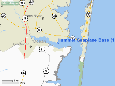
Hummel Seaplane Base Airport |
Location & QuickFacts
| FAA Information Effective: | 2008-09-25 |
| Airport Identifier: | 16NJ |
| Airport Status: | Operational |
| Longitude/Latitude: | 074-08-08.4990W/39-56-14.4250N
-74.135694/39.937340 (Estimated) |
| Elevation: | 0 ft / 0.00 m (Estimated) |
| Land: | 0 acres |
| From nearest city: | 1 nautical miles S of Island Heights, NJ |
| Location: | Ocean County, NJ |
| Magnetic Variation: | 12W (1985) |
Owner & Manager
| Ownership: | Privately owned |
| Owner: | William T Hummel |
| Address: | One Timber Fare
Spring House, PA 19477 |
| Phone number: | 215-628-4444 |
| Address: |
|
Airport Operations and Facilities
| Airport Use: | Private |
| Wind indicator: | No |
| Segmented Circle: | No |
| Control Tower: | No |
| Landing fee charge: | No |
| Sectional chart: | Washington |
| Region: | AEA - Eastern |
| Boundary ARTCC: | ZNY - New York |
| Tie-in FSS: | MIV - Millville |
| FSS on Airport: | No |
| FSS Toll Free: | 1-800-WX-BRIEF |
Runway Information
Runway ALL/WAY
| Dimension: | 15000 x 4000 ft / 4572.0 x 1219.2 m |
| Surface: | WATER, |
| |
Runway ALL |
Runway WAY |
| Traffic Pattern: | Left | Left |
|
Radio Navigation Aids
| ID |
Type |
Name |
Ch |
Freq |
Var |
Dist |
| EWR | FAN MARKER | Maryann | | | 11W | 46.1 nm |
| NEL | NDB | Lakehurst | | 396.00 | 13W | 11.2 nm |
| OGY | NDB | Bridge | | 414.00 | 12W | 39.6 nm |
| NXX | NDB | Willow Grove | | 388.00 | 12W | 48.9 nm |
| NEL | TACAN | Lakehurst | 055X | | 11W | 11.7 nm |
| NXX | TACAN | Willow Grove | 061X | | 10W | 49.0 nm |
| NEL | UHF/NDB | Lakehurst | | 274.80 | 13W | 11.3 nm |
| PNE | VOR | North Philadelphia | | 112.00 | 10W | 41.2 nm |
| COL | VOR/DME | Colts Neck | 101X | 115.40 | 11W | 22.5 nm |
| ARD | VOR/DME | Yardley | 019X | 108.20 | 10W | 40.3 nm |
| CRI | VOR/DME | Canarsie | 070X | 112.30 | 11W | 42.1 nm |
| JFK | VOR/DME | Kennedy | 106X | 115.90 | 12W | 45.0 nm |
| SBJ | VOR/DME | Solberg | 076X | 112.90 | 10W | 47.7 nm |
| CYN | VORTAC | Coyle | 081X | 113.40 | 10W | 15.4 nm |
| GXU | VORTAC | Mc Guire | 043X | 110.60 | 11W | 21.7 nm |
| RBV | VORTAC | Robbinsville | 085X | 113.80 | 10W | 23.0 nm |
| ACY | VORTAC | Atlantic City | 023X | 108.60 | 10W | 35.4 nm |
| VCN | VORTAC | Cedar Lake | 099X | 115.20 | 10W | 45.3 nm |
| JFK | VOT | Kennedy | | 115.10 | | 45.0 nm |
Remarks
Images and information placed above are from
http://www.airport-data.com/airport/16NJ/
We thank them for the data!
| General Info
|
| Country |
United States
|
| State |
NEW JERSEY
|
| FAA ID |
16NJ
|
| Latitude |
39-56-14.425N
|
| Longitude |
074-08-08.499W
|
| Elevation |
0 feet
|
| Near City |
ISLAND HEIGHTS
|
We don't guarantee the information is fresh and accurate. The data may
be wrong or outdated.
For more up-to-date information please refer to other sources.
|
|


