 |
|
| Hackettstown Airport |
| IATA: none – ICAO: none – FAA LID: N05 |
| Summary |
| Airport type |
Public use |
| Owner/Operator |
Donald Schwanda |
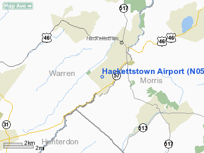
| Serves |
Hackettstown, New Jersey |
| Location |
Mansfield Township, Warren County, New Jersey |
| Elevation AMSL |
670 ft / 204 m |
| Coordinates |
40°49′18.4″N 074°51′15″W / 40.821778°N 74.85417°W / 40.821778; -74.85417Coordinates: 40°49′18.4″N 074°51′15″W / 40.821778°N 74.85417°W / 40.821778; -74.85417 |
| Runways |
| Direction |
Length |
Surface |
| ft |
m |
| 5/23 |
2,200 |
671 |
Asphalt |
| Statistics (2005) |
| Aircraft operations |
19,000 |
| Based aircraft |
36 |
| Source: Federal Aviation Administration |
Hackettstown Airport (FAA LID: N05) is a public-use airport located in the Beattystown area of Mansfield Township, Warren County, New Jersey, United States, three nautical miles (5.56 km) southwest of the central business district of Hackettstown. The airport is privately owned. Although most U.S. airports use the same three-letter location identifier for the FAA and IATA, this airport is assigned N05 by the FAA but has no designation from the IATA
Facilities and aircraft
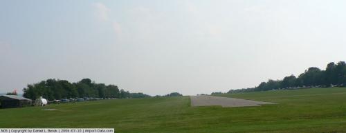
Hackettstown Airport covers an area of 65 acres (26.3 ha) at an elevation of 670 feet (204 m) above mean sea level. It has one runway designated 05/23 with an asphalt surface measuring 2,200 by 50 feet (671 x 15 m).
For the 12-month period ending December 31, 2005, the airport had 19,000 aircraft operations, an average of 52 per day: 100% general aviation. At that time there were 36 aircraft based at this airport: 100% single-engine.
The above content comes from Wikipedia and is published under free licenses – click here to read more.
 |
(Click on the photo to enlarge) |
Location & QuickFacts
| FAA Information Effective: | 2008-09-25 |
| Airport Identifier: | N05 |
| Airport Status: | Operational |
| Longitude/Latitude: | 074-51-18.6020W/40-49-12.3570N
-74.855167/40.820099 (Estimated) |
| Elevation: | 670 ft / 204.22 m (Estimated) |
| Land: | 65 acres |
| From nearest city: | 3 nautical miles SW of Hackettstown, NJ |
| Location: | Warren County, NJ |
| Magnetic Variation: | 12W (1985) |
Owner & Manager
| Ownership: | Privately owned |
| Owner: | Donald Schwanda |
| Address: | 115 Airport Rd
Hackettstown, NJ 07840 |
| Phone number: | 908-852-4664 |
| Manager: | Donald Schwanda |
| Address: | 115 Airport Rd
Hackettstown, NJ 07840 |
| Phone number: | 908-852-4664 |
Airport Operations and Facilities
| Airport Use: | Open to public |
| Wind indicator: | Yes |
| Segmented Circle: | No |
| Control Tower: | No |
| Landing fee charge: | No |
| Sectional chart: | New York |
| Region: | AEA - Eastern |
| Boundary ARTCC: | ZNY - New York |
| Tie-in FSS: | MIV - Millville |
| FSS on Airport: | No |
| FSS Toll Free: | 1-800-WX-BRIEF |
| NOTAMs Facility: | MIV (NOTAM-d service avaliable) |
Airport Communications
Airport Services
| Fuel available: | 100LL |
| Airframe Repair: | MINOR |
| Power Plant Repair: | MINOR |
| Bottled Oxygen: | NONE |
| Bulk Oxygen: | NONE |
Runway Information
Runway 05/23
| Dimension: | 2200 x 50 ft / 670.6 x 15.2 m |
| Surface: | ASPH, Good Condition |
| Weight Limit: | Single wheel: 5000 lbs. |
| |
Runway 05 |
Runway 23 |
| Traffic Pattern: | Left | Left |
| Obstruction: | 27 ft tree, 227.0 ft from runway, 63 ft right of centerline, 1:1 slope to clear
RWY 05 +51 FT TREES, 117 FT FM THLD,96 FT R. | 9 ft tree, 208.0 ft from runway, 51 ft left of centerline
RY 23 ROAD WITH 15 FT VEHICLES 45 FEET FROM RUNWAY END. |
|
Radio Navigation Aids
| ID |
Type |
Name |
Ch |
Freq |
Var |
Dist |
| EWR | FAN MARKER | Maryann | | | 11W | 31.2 nm |
| CAT | NDB | Chatham | | 254.00 | 11W | 19.9 nm |
| UKT | NDB | Quakertown | | 208.00 | 12W | 31.2 nm |
| DYL | NDB | Doylestown | | 237.00 | 10W | 31.6 nm |
| PNJ | NDB | Paterson | | 347.00 | 12W | 32.9 nm |
| NXX | NDB | Willow Grove | | 388.00 | 12W | 40.2 nm |
| LQX | NDB | Carbon | | 339.00 | 12W | 41.1 nm |
| ING | NDB | Ambler | | 275.00 | 11W | 46.1 nm |
| OGY | NDB | Bridge | | 414.00 | 12W | 46.8 nm |
| SW | NDB | Neely | | 335.00 | 14W | 49.1 nm |
| NXX | TACAN | Willow Grove | 061X | | 10W | 39.9 nm |
| PNE | VOR | North Philadelphia | | 112.00 | 10W | 44.9 nm |
| BWZ | VOR/DME | Broadway | 089X | 114.20 | 11W | 2.0 nm |
| STW | VOR/DME | Stillwater | 033X | 109.60 | 11W | 10.6 nm |
| SBJ | VOR/DME | Solberg | 076X | 112.90 | 10W | 15.2 nm |
| CKZ | VOR/DME | Pennridge | 025Y | 108.85 | 12W | 32.5 nm |
| ARD | VOR/DME | Yardley | 019X | 108.20 | 10W | 34.2 nm |
| TEB | VOR/DME | Teterboro | 021X | 108.40 | 11W | 36.1 nm |
| HUO | VOR/DME | Huguenot | 108X | 116.10 | 11W | 37.4 nm |
| ETX | VOR/DME | East Texas | 039X | 110.20 | 09W | 40.4 nm |
| COL | VOR/DME | Colts Neck | 101X | 115.40 | 11W | 44.1 nm |
| LGA | VOR/DME | La Guardia | 078X | 113.10 | 12W | 44.5 nm |
| CRI | VOR/DME | Canarsie | 070X | 112.30 | 11W | 45.5 nm |
| SAX | VORTAC | Sparta | 104X | 115.70 | 11W | 20.7 nm |
| FJC | VORTAC | Allentown | 122X | 117.50 | 10W | 27.9 nm |
| RBV | VORTAC | Robbinsville | 085X | 113.80 | 10W | 40.6 nm |
| LVZ | VORTAC | Wilkes-barre | 053X | 111.60 | 10W | 46.6 nm |
| PTW | VORTAC | Pottstown | 112X | 116.50 | 09W | 48.3 nm |
| LHY | VORTAC | Lake Henry | 045X | 110.80 | 10W | 48.6 nm |
Images and information placed above are from
http://www.airport-data.com/airport/N05/
We thank them for the data!
| General Info
|
| Country |
United States
|
| State |
NEW JERSEY
|
| FAA ID |
N05
|
| Latitude |
40-49-12.357N
|
| Longitude |
074-51-18.602W
|
| Elevation |
670 feet
|
| Near City |
HACKETTSTOWN
|
We don't guarantee the information is fresh and accurate. The data may
be wrong or outdated.
For more up-to-date information please refer to other sources.
|
|


