|
|
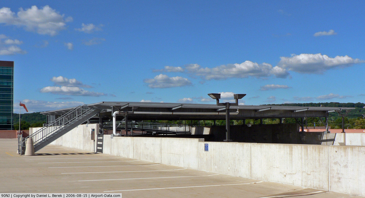
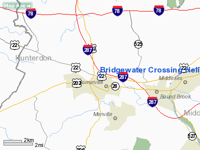
Bridgewater Crossing Heliport |
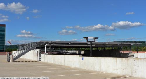 |
(Click on the photo to enlarge) |
Location & QuickFacts
| FAA Information Effective: | 2008-09-25 |
| Airport Identifier: | 90NJ |
| Airport Status: | Operational |
| Longitude/Latitude: | 074-36-50.0000W/40-34-56.0000N
-74.613889/40.582222 (Estimated) |
| Elevation: | 140 ft / 42.67 m (Estimated) |
| Land: | 0 acres |
| From nearest city: | 0 nautical miles S of Bridgewater, NJ |
| Location: | Somerset County, NJ |
| Magnetic Variation: | () |
Owner & Manager
| Ownership: | Privately owned |
| Owner: | Wells-reit-bridgewater, Nj, Llc |
| Address: | 200 Crossing Blvd
Bridgewater, NJ 08807 |
| Phone number: | 908-429-2129 |
| Manager: | Ernest Vitiello |
| Address: | 200 Crossing Blvd
Bridgwater, NJ 08807 |
| Phone number: | 908-429-2129 |
Airport Operations and Facilities
| Airport Use: | Private
MEDICAL. |
| Wind indicator: | Yes |
| Segmented Circle: | No |
| Control Tower: | No |
| Lighting Schedule: | PHONE REQ
FOR PERIMETER LGTS CALL 908-243-1023. |
| Sectional chart: | New York |
| Region: | AEA - Eastern |
| Boundary ARTCC: | ZNY - New York |
| Tie-in FSS: | MIV - Millville |
| FSS Toll Free: | 1-800-WX-BRIEF |
Runway Information
Helipad H1
| Dimension: | 60 x 60 ft / 18.3 x 18.3 m |
| Surface: | MATS,
ROOFTOP. |
| |
Runway H1 |
Runway |
| Traffic Pattern: | Left | Left |
| Markings: | Basic, | , |
|
Radio Navigation Aids
| ID |
Type |
Name |
Ch |
Freq |
Var |
Dist |
| EWR | FAN MARKER | Maryann | | | 11W | 20.8 nm |
| CAT | NDB | Chatham | | 254.00 | 11W | 12.7 nm |
| DYL | NDB | Doylestown | | 237.00 | 10W | 27.6 nm |
| PNJ | NDB | Paterson | | 347.00 | 12W | 30.4 nm |
| UKT | NDB | Quakertown | | 208.00 | 12W | 32.6 nm |
| OGY | NDB | Bridge | | 414.00 | 12W | 33.4 nm |
| NXX | NDB | Willow Grove | | 388.00 | 12W | 33.9 nm |
| NEL | NDB | Lakehurst | | 396.00 | 13W | 34.7 nm |
| ING | NDB | Ambler | | 275.00 | 11W | 41.2 nm |
| NXX | TACAN | Willow Grove | 061X | | 10W | 33.7 nm |
| NEL | TACAN | Lakehurst | 055X | | 11W | 34.9 nm |
| NEL | UHF/NDB | Lakehurst | | 274.80 | 13W | 34.7 nm |
| PNE | VOR | North Philadelphia | | 112.00 | 10W | 35.1 nm |
| SBJ | VOR/DME | Solberg | 076X | 112.90 | 10W | 5.8 nm |
| BWZ | VOR/DME | Broadway | 089X | 114.20 | 11W | 16.1 nm |
| ARD | VOR/DME | Yardley | 019X | 108.20 | 10W | 23.9 nm |
| COL | VOR/DME | Colts Neck | 101X | 115.40 | 11W | 26.4 nm |
| STW | VOR/DME | Stillwater | 033X | 109.60 | 11W | 27.4 nm |
| TEB | VOR/DME | Teterboro | 021X | 108.40 | 11W | 29.8 nm |
| CRI | VOR/DME | Canarsie | 070X | 112.30 | 11W | 32.9 nm |
| CKZ | VOR/DME | Pennridge | 025Y | 108.85 | 12W | 32.9 nm |
| LGA | VOR/DME | La Guardia | 078X | 113.10 | 12W | 35.8 nm |
| JFK | VOR/DME | Kennedy | 106X | 115.90 | 12W | 38.6 nm |
| ETX | VOR/DME | East Texas | 039X | 110.20 | 09W | 48.8 nm |
| HUO | VOR/DME | Huguenot | 108X | 116.10 | 11W | 49.7 nm |
| RBV | VORTAC | Robbinsville | 085X | 113.80 | 10W | 23.5 nm |
| SAX | VORTAC | Sparta | 104X | 115.70 | 11W | 29.4 nm |
| GXU | VORTAC | Mc Guire | 043X | 110.60 | 11W | 34.4 nm |
| FJC | VORTAC | Allentown | 122X | 117.50 | 10W | 39.3 nm |
| CYN | VORTAC | Coyle | 081X | 113.40 | 10W | 46.7 nm |
| PTW | VORTAC | Pottstown | 112X | 116.50 | 09W | 48.4 nm |
| JFK | VOT | Kennedy | | 115.10 | | 38.2 nm |
Remarks
- PRVDD CLEAR 8:1 INGRESS/EGRESS, APPROPRIATE MKGS FOR INGRESS/EGRESS, LGTD WINDSOCK, VEHICULAR TFC CONTROLLED, MIMNIMIZE NOISE.
Images and information placed above are from
http://www.airport-data.com/airport/90NJ/
We thank them for the data!
|
|