 |
|
Location & QuickFacts
| FAA Information Effective: | 2008-09-25 |
| Airport Identifier: | 26JY |
| Airport Status: | Operational |
| Longitude/Latitude: | 074-54-38.0000W/39-44-18.4000N
-74.910556/39.738444 (Estimated) |
| Elevation: | 150 ft / 45.72 m (Estimated) |
| Land: | 0 acres |
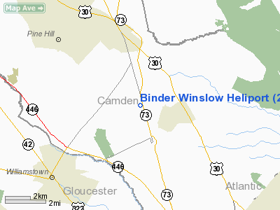
| From nearest city: | 3 nautical miles S of Winslow, NJ |
| Location: | Camden County, NJ |
| Magnetic Variation: | () |
Owner & Manager
| Ownership: | Privately owned |
| Owner: | Ole Hanson & Sons Inc
THOMAS M. PLAYER |
| Address: | Po Box 1020
Cologne, NJ 08213 |
| Phone number: | 609-965-3700 |
| Manager: | Alan Binder
LESSEE IS BINDER MACHINERY COMPANY. |
| Address: | 2820 Hamilton Blvd
South Plainfield, NJ 07016 |
| Phone number: | 856-767-5900 |
Airport Operations and Facilities
| Airport Use: | Private |
| Wind indicator: | Yes |
| Control Tower: | No |
| Sectional chart: | Washington |
| Region: | AEA - Eastern |
| Boundary ARTCC: | ZDC - Washington |
| Responsible ARTCC: | ZDC - Washington |
| Tie-in FSS: | MIV - Millville |
| FSS Toll Free: | 1-800-WX-BRIEF |
Runway Information
Helipad H1
| Dimension: | 80 x 80 ft / 24.4 x 24.4 m |
| Surface: | ASPH-GRVL, |
| |
Runway H1 |
Runway |
| Traffic Pattern: | Left | Left |
|
Radio Navigation Aids
| ID |
Type |
Name |
Ch |
Freq |
Var |
Dist |
| RNB | NDB | Rainbow | | 363.00 | 11W | 21.9 nm |
| ING | NDB | Ambler | | 275.00 | 11W | 29.0 nm |
| NXX | NDB | Willow Grove | | 388.00 | 12W | 29.2 nm |
| NEL | NDB | Lakehurst | | 396.00 | 13W | 32.3 nm |
| DYL | NDB | Doylestown | | 237.00 | 10W | 37.2 nm |
| UKT | NDB | Quakertown | | 208.00 | 12W | 44.9 nm |
| NXX | TACAN | Willow Grove | 061X | | 10W | 29.5 nm |
| NEL | TACAN | Lakehurst | 055X | | 11W | 31.4 nm |
| DOV | TACAN | Dover | 037X | | 09W | 44.7 nm |
| NEL | UHF/NDB | Lakehurst | | 274.80 | 13W | 32.3 nm |
| PNE | VOR | North Philadelphia | | 112.00 | 10W | 21.2 nm |
| ARD | VOR/DME | Yardley | 019X | 108.20 | 10W | 30.9 nm |
| CKZ | VOR/DME | Pennridge | 025Y | 108.85 | 12W | 42.9 nm |
| COL | VOR/DME | Colts Neck | 101X | 115.40 | 11W | 48.8 nm |
| VCN | VORTAC | Cedar Lake | 099X | 115.20 | 10W | 12.3 nm |
| OOD | VORTAC | Woodstown | 075X | 112.80 | 10W | 19.2 nm |
| GXU | VORTAC | Mc Guire | 043X | 110.60 | 11W | 21.8 nm |
| CYN | VORTAC | Coyle | 081X | 113.40 | 10W | 22.6 nm |
| ACY | VORTAC | Atlantic City | 023X | 108.60 | 10W | 23.0 nm |
| DQO | VORTAC | Dupont | 087X | 114.00 | 10W | 32.4 nm |
| RBV | VORTAC | Robbinsville | 085X | 113.80 | 10W | 33.8 nm |
| MXE | VORTAC | Modena | 079X | 113.20 | 09W | 36.7 nm |
| SIE | VORTAC | Sea Isle | 095X | 114.80 | 09W | 39.0 nm |
| ENO | VORTAC | Smyrna | 051X | 111.40 | 09W | 41.4 nm |
| PTW | VORTAC | Pottstown | 112X | 116.50 | 09W | 41.7 nm |
| PHL | VOT | Philadelphia Intl | | 109.80 | | 17.4 nm |
Remarks
- PRVDD AREA MKD; WIND INDICATOR IS MAINTAINED; PVT USE; & VFR CONDITIONS.
Images and information placed above are from
http://www.airport-data.com/airport/26JY/
We thank them for the data!
|
|


