 |
|
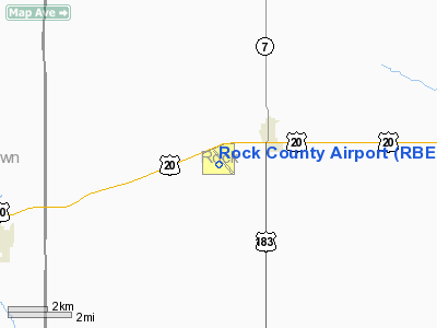
| Rock County Airport |
| IATA: none – ICAO: KRBE – FAA LID: RBE |
| Summary |
| Airport type |
Public |
| Owner |
Rock County Airport Authority |
| Serves |
Bassett, Nebraska |
| Elevation AMSL |
2,349 ft / 716 m |
| Coordinates |
42°34′16″N 099°34′10″W / 42.57111°N 99.56944°W / 42.57111; -99.56944 |
| Runways |
| Direction |
Length |
Surface |
| ft |
m |
| 13/31 |
4,699 |
1,432 |
Concrete |
| 2/20 |
2,202 |
671 |
Turf |
| Statistics (2008) |
| Aircraft operations |
2,000 |
| Based aircraft |
4 |
| Source: Federal Aviation Administration |
Rock County Airport (ICAO: KRBE, FAA LID: RBE) is a public use airport located two nautical miles (3.7 km) southwest of the central business district of Bassett, a city in Rock County, Nebraska, United States. It is owned by the Rock County Airport Authority. According to the FAA's National Plan of Integrated Airport Systems for 2009–2013, it is classified as a general aviation airport.
Although many U.S. airports use the same three-letter location identifier for the FAA and IATA, this airport is assigned RBE by the FAA but has no designation from the IATA (which assigned RBE to Ratanakiri Airport in Ratanakiri, Cambodia).
Facilities and aircraft
Rock County Airport covers an area of 228 acres (92 ha) at an elevation of 2,349 feet (716 m) above mean sea level. It has two runways: 13/31 is 4,699 by 75 feet (1,432 x 23 m) with a concrete surface and 2/20 is 2,202 by 120 feet (671 x 37 m) with a turf surface.
For the 12-month period ending August 19, 2008, the airport had 2,000 general aviation aircraft operations, an average of 166 per month. At that time there were 4 aircraft based at this airport: 100% single-engine.
The above content comes from Wikipedia and is published under free licenses – click here to read more.
Location & QuickFacts
| FAA Information Effective: | 2008-09-25 |
| Airport Identifier: | RBE |
| Airport Status: | Operational |
| Longitude/Latitude: | 099-34-06.1000W/42-34-10.8000N
-99.568361/42.569667 (Estimated) |
| Elevation: | 2349 ft / 715.98 m (Surveyed) |
| Land: | 228 acres |
| From nearest city: | 2 nautical miles SW of Bassett, NE |
| Location: | Rock County, NE |
| Magnetic Variation: | 08E (1990) |
Owner & Manager
| Ownership: | Publicly owned |
| Owner: | Rock County Airport Authority |
| Address: | Jim Nelson, Chairman, Po Box 385
Bassett, NE 68714 |
| Phone number: | 402-684-3436 |
| Manager: | Bill Austin |
| Address: | 507 Panzer
Bassett, NE 68714 |
| Phone number: | 402-684-3445 |
Airport Operations and Facilities
| Airport Use: | Open to public |
| Wind indicator: | Yes |
| Segmented Circle: | Yes |
| Control Tower: | No |
| Lighting Schedule: | DUSK-DAWN
ACTVT MIRL RY 13/31 & PAPI RYS 13 & 31 - 122.8. |
| Beacon Color: | Clear-Green (lighted land airport) |
| Landing fee charge: | No |
| Sectional chart: | Omaha |
| Region: | ACE - Central |
| Boundary ARTCC: | ZDV - Denver |
| Tie-in FSS: | OLU - Columbus |
| FSS on Airport: | No |
| FSS Toll Free: | 1-800-WX-BRIEF |
| NOTAMs Facility: | OLU (NOTAM-d service avaliable) |
| Federal Agreements: | N1 |
Airport Communications
Airport Services
| Fuel available: | 100LL
FOR FUEL PHONE 684-3600. |
| Airframe Repair: | NONE |
| Power Plant Repair: | NONE |
| Bottled Oxygen: | NONE |
| Bulk Oxygen: | NONE |
Runway Information
Runway 02/20
| Dimension: | 2250 x 120 ft / 685.8 x 36.6 m |
| Surface: | TURF, Fair Condition |
| |
Runway 02 |
Runway 20 |
| Longitude: | 099-34-27.9400W | 099-34-10.6550W |
| Latitude: | 42-34-18.1080N | 42-34-36.1920N |
| Alignment: | 35 | 127 |
| Traffic Pattern: | Left | Left |
| Obstruction: | 24 ft pole, 440.0 ft from runway, 180 ft right of centerline, 18:1 slope to clear | 15 ft road, 320.0 ft from runway, 157 ft right of centerline, 21:1 slope to clear |
|
Runway 13/31
| Dimension: | 4698 x 75 ft / 1432.0 x 22.9 m |
| Surface: | CONC, Good Condition |
| Weight Limit: | Single wheel: 4000 lbs. |
| Edge Lights: | Medium |
| |
Runway 13 |
Runway 31 |
| Longitude: | 099-34-25.9600W | 099-33-46.2860W |
| Latitude: | 42-34-28.7580N | 42-33-52.7920N |
| Elevation: | 2344.00 ft | 2349.00 ft |
| Alignment: | 127 | 127 |
| Traffic Pattern: | Left | Left |
| Markings: | Non-precision instrument, Good Condition | Non-precision instrument, Good Condition |
| VASI: | 2-light PAPI on left side | 2-light PAPI on left side |
| Obstruction: | 18 ft road, 565.0 ft from runway, 185 ft left of centerline, 20:1 slope to clear | , 50:1 slope to clear |
|
Radio Navigation Aids
| ID |
Type |
Name |
Ch |
Freq |
Var |
Dist |
| RBE | NDB | Rock County | | 341.00 | 08E | 0.5 nm |
| VTN | NDB | Valentine | | 314.00 | 08E | 46.8 nm |
| ANW | VOR/DME | Ainsworth | 074X | 112.70 | 09E | 18.7 nm |
| ONL | VORTAC | O'neill | 086X | 113.90 | 10E | 39.5 nm |
Remarks
Images and information placed above are from
http://www.airport-data.com/airport/RBE/
We thank them for the data!
| General Info
|
| Country |
United States
|
| State |
NEBRASKA
|
| FAA ID |
RBE
|
| Latitude |
42-34-10.800N
|
| Longitude |
099-34-06.100W
|
| Elevation |
2349 feet
|
| Near City |
BASSETT
|
We don't guarantee the information is fresh and accurate. The data may
be wrong or outdated.
For more up-to-date information please refer to other sources.
|
|


