 |
|
North Platte Rgnl Airport Lee Bird Field Airport |
North Platte Regional Airport
Lee Bird Field |
 |
| IATA: LBF – ICAO: KLBF – FAA LID: LBF |
| Summary |
| Airport type |
Public |
| Owner |
North Platte Airport Authority |
| Serves |
North Platte, Nebraska |
| Elevation AMSL |
2,777 ft / 846 m |
| Coordinates |
41°07′34″N 100°41′01″W / 41.12611°N 100.68361°W / 41.12611; -100.68361 |
| Website |
NorthPlatteAirport.com |
| Runways |
| Direction |
Length |
Surface |
| ft |
m |
| 12/30 |
8,000 |
2,438 |
Concrete |
| 17/35 |
4,436 |
1,352 |
Asphalt |
| Statistics (2008) |
| Aircraft operations |
37,814 |
| Based aircraft |
48 |
| Source: Federal Aviation Administration |
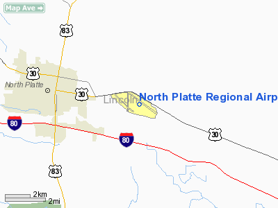
North Platte Regional Airport (IATA: LBF, ICAO: KLBF, FAA LID: LBF), also known as Lee Bird Field, is a public use airport located three nautical miles (6 km) east of the central business district of North Platte, a city in Lincoln County, Nebraska, United States. It is owned by the North Platte Airport Authority. The airport is served by one commercial airline, with service subsidized by the Essential Air Service program. History
North Platte Regional Airport was originally called North Platte Field and was built in 1921 using private funds. The original location was on the east side of the North Platte River near the river bridge south of U.S. Highway 30. The first hangar and terminal buildings were constructed there. The airport was the site of the first night airmail flight which occurred on February 22, 1921. The field was lit using fuel burning barrels and the plane landed at 7:48 p.m. and then piloted onward toward Omaha at 10:44 p.m. after repairs were made to the de Havilland 4 aircraft.
In 1929, the City of North Platte purchased the airfield and leased it to the Boeing Transport Company, an original part of United Airlines. More construction was done in 1941 and the site became the site of a B-17 training command. The same year the airport was renamed Lee Bird Field after Lee Bird, the son of a North Platte family, who was killed in 1918 while training as a pilot for World War I. The Airport Authority began operating the airport in July 1963 and the airport was officially renamed the North Platte Regional Airport Lee Bird Field in June 1992.
Facilities and aircraft
North Platte Regional Airport covers an area of 1,544 acres (625 ha) at an elevation of 2,777 feet (846 m) above mean sea level. It has two runways: 12/30 is 8,000 by 150 feet (2,438 x 46 m) with a concrete surface; 17/35 is 4,436 by 100 feet (1,352 x 30 m) with an asphalt surface.
For the 12-month period ending December 31, 2008, the airport had 37,814 aircraft operations, an average of 103 per day: 66% general aviation, 17% scheduled commercial, 15% air taxi and 1% military. At that time there were 48 aircraft based at this airport: 88% single-engine, 6% multi-engine and 6% jet.
Airlines and destinations
| Airlines |
Destinations |
| Great Lakes Airlines |
Denver |
The above content comes from Wikipedia and is published under free licenses – click here to read more.
Location & QuickFacts
| FAA Information Effective: | 2008-09-25 |
| Airport Identifier: | LBF |
| Airport Status: | Operational |
| Longitude/Latitude: | 100-41-01.2000W/41-07-34.4000N
-100.683667/41.126222 (Estimated) |
| Elevation: | 2777 ft / 846.43 m (Surveyed) |
| Land: | 1544 acres |
| From nearest city: | 3 nautical miles E of North Platte, NE |
| Location: | Lincoln County, NE |
| Magnetic Variation: | 09E (1985) |
Owner & Manager
| Ownership: | Publicly owned |
| Owner: | North Platte Airport Auth |
| Address: | Po Box 1517
North Platte, NE 69103 |
| Phone number: | 308-532-1900 |
| Manager: | Mr. Mike Sharkey |
| Address: | Po Box 1517
North Platte, NE 69103 |
| Phone number: | 308-532-1900 |
Airport Operations and Facilities
| Airport Use: | Open to public |
| Wind indicator: | Yes |
| Segmented Circle: | Yes |
| Control Tower: | No |
| Lighting Schedule: | DUSK-DAWN
ACTVT HIRL RY 12/30; MIRL RY 17/35; VASI RYS 12 & 35; PAPI RY 30; MALSR RY 30 & REIL RY 35 - CTAF. |
| Beacon Color: | Clear-Green (lighted land airport) |
| Landing fee charge: | No |
| Sectional chart: | Omaha |
| Region: | ACE - Central |
| Boundary ARTCC: | ZDV - Denver |
| Tie-in FSS: | OLU - Columbus |
| FSS on Airport: | No |
| FSS Toll Free: | 1-800-WX-BRIEF |
| NOTAMs Facility: | LBF (NOTAM-d service avaliable) |
| Certification type/date: | II A S 05/199
PPR 24 HRS FOR UNSKED ACR OPNS WITH MORE THAN 30 PSGR SEATS CALL AMGR 308-532-1900, ARFF INDEX B EQUIPMENT PROVIDED. |
| Federal Agreements: | NGY3 |
Airport Communications
| CTAF: | 123.000 |
| Unicom: | 123.000 |
Airport Services
| Fuel available: | 100LLA |
| Airframe Repair: | MAJOR |
| Power Plant Repair: | MAJOR |
| Bottled Oxygen: | HIGH/LOW |
| Bulk Oxygen: | LOW |
Runway Information
Runway 12/30
| Dimension: | 8000 x 150 ft / 2438.4 x 45.7 m |
| Surface: | CONC, |
| Surface Treatment: | Saw-cut or plastic Grooved |
| Weight Limit: | Single wheel: 75000 lbs.
Dual wheel: 110000 lbs.
Dual tandem wheel: 190000 lbs. |
| Edge Lights: | High |
| |
Runway 12 |
Runway 30 |
| Longitude: | 100-41-24.8027W | 100-40-00.1290W |
| Latitude: | 41-07-56.0680N | 41-07-09.7300N |
| Elevation: | 2777.00 ft | 2769.00 ft |
| Alignment: | 126 | 127 |
| ILS Type: | | ILS
|
| Traffic Pattern: | Left | Left |
| Markings: | Precision instrument, Good Condition | Precision instrument, Good Condition |
| Crossing Height: | 55.00 ft | 55.00 ft |
| VASI: | 4-box on left side | 4-light PAPI on left side |
| Visual Glide Angle: | 3.00° | 3.00° |
| Approach lights: | | MALSR |
|
Runway 17/35
| Dimension: | 4436 x 100 ft / 1352.1 x 30.5 m |
| Surface: | ASPH, Good Condition |
| Weight Limit: | Single wheel: 28000 lbs.
Dual wheel: 48000 lbs.
Dual tandem wheel: 86000 lbs. |
| Edge Lights: | Medium |
| |
Runway 17 |
Runway 35 |
| Longitude: | 100-41-34.3038W | 100-41-35.4180W |
| Latitude: | 41-07-58.9057N | 41-07-15.0926N |
| Elevation: | 2775.00 ft | 2773.00 ft |
| Alignment: | 127 | 1 |
| Traffic Pattern: | Left | Left |
| Markings: | Non-precision instrument, Good Condition | Non-precision instrument, Good Condition |
| Crossing Height: | 0.00 ft | 37.00 ft |
| Displaced threshold: | 0.00 ft | 301.00 ft |
| VASI: | | 4-box on left side |
| Visual Glide Angle: | 0.00° | 3.00° |
| Runway End Identifier: | | Yes |
| Obstruction: | 21 ft road, 850.0 ft from runway, 30:1 slope to clear | 27 ft tree, 675.0 ft from runway, 150 ft left of centerline, 17:1 slope to clear
RWY 35 APCH RATIO 36:1 TO DSPLCD THLD. |
| Decleard distances: | Take off run available 4436.00 ft
Take off distance available 4436.00 ft
Actual stop distance available 4135.00 ft
Landing distance available 4135.00 ft
| Take off run available 4436.00 ft
Take off distance available 4436.00 ft
Actual stop distance available 4436.00 ft
Landing distance available 4135.00 ft
|
|
Radio Navigation Aids
| ID |
Type |
Name |
Ch |
Freq |
Var |
Dist |
| DWL | NDB | Willow | | 353.00 | 08E | 31.6 nm |
| RRX | NDB | Darr | | 326.00 | 07E | 41.2 nm |
| GGF | NDB | Grant | | 359.00 | 09E | 49.9 nm |
| OZB | VOR | Cozad | | 109.00 | 09E | 34.5 nm |
| SAE | VOR/DME | Searle | 39X | 110.20 | 11E | 49.5 nm |
| CUZ | VOR/DME | Custer County | 19X | 108.20 | 08E | 49.8 nm |
| LBF | VORTAC | North Platte | 121X | 117.40 | 11E | 5.5 nm |
| HCT | VORTAC | Hayes Center | 124X | 117.70 | 11E | 41.9 nm |
Remarks
- WATERFOWL ON & INVOF ARPT.
- 5 FT DIKE +3 FT FENCE 100 FT FM AER 35.
- ALL CAT D ACFT (WITH SPEEDS OF 141-166 KNOTS) OPERATING ON RY 12/30 MUST MAINTAIN A TPA OF 1,500 FT WHEN IN THE TFC PAT.
- TWY 'A' CLSD INDEFLY.
Images and information placed above are from
http://www.airport-data.com/airport/LBF/
We thank them for the data!
| General Info
|
| Country |
United States
|
| State |
NEBRASKA
|
| FAA ID |
LBF
|
| Latitude |
41-07-34.363N
|
| Longitude |
100-41-01.155W
|
| Elevation |
2779 feet
|
| Near City |
NORTH PLATTE
|
We don't guarantee the information is fresh and accurate. The data may
be wrong or outdated.
For more up-to-date information please refer to other sources.
|
|


