 |
|
| North Omaha Airport |
| IATA: none – ICAO: none – FAA LID: 3NO |
| Summary |
| Airport type |
Public use |
| Owner |
Keith Edquist |
| Serves |
Omaha, Nebraska |
| Elevation AMSL |
1,322 ft / 403 m |
| Coordinates |
41°22′06″N 096°01′21″W / 41.36833°N 96.0225°W / 41.36833; -96.0225 |
| Runways |
| Direction |
Length |
Surface |
| ft |
m |
| 17/35 |
2,480 |
756 |
Concrete |
| Statistics (2004) |
| Aircraft operations |
14,250 |
| Source: Federal Aviation Administration |
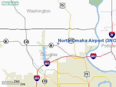
North Omaha Airport (FAA LID: 3NO) is a privately-owned, public-use airport located 7 nautical miles (13 km) northwest of the central business district of Omaha, a city in Douglas County, Nebraska, United States.
Facilities and aircraft
North Omaha Airport covers an area of 100 acres (0.16 sq mi; 0.40 km) at an elevation of 1,322 feet (403 m) above mean sea level. It has one runway designated 17/35 that is 2,480 x 40 feet (756 x 12 m) with a concrete surface. For the 12-month period ending August 31, 2004, the airport had 14,250 general aviation aircraft operations.
The above content comes from Wikipedia and is published under free licenses – click here to read more.
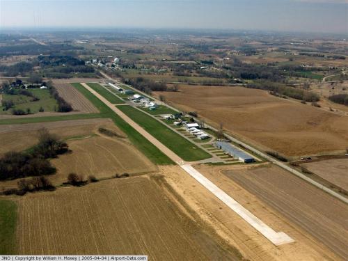 |
(Click on the photo to enlarge) |
Location & QuickFacts
| FAA Information Effective: | 2008-09-25 |
| Airport Identifier: | 3NO |
| Airport Status: | Operational |
| Longitude/Latitude: | 096-01-21.0530W/41-22-05.9870N
-96.022515/41.368330 (Estimated) |
| Elevation: | 1322 ft / 402.95 m (Estimated) |
| Land: | 100 acres |
| From nearest city: | 7 nautical miles NW of Omaha, NE |
| Location: | Douglas County, NE |
| Magnetic Variation: | 06E (1985) |
Owner & Manager
| Ownership: | Privately owned |
| Owner: | Keith Edquist |
| Address: | 12001 N 72nd
Omaha, NE 68122 |
| Phone number: | 402-571-7585 |
| Manager: | Keith Edquist |
| Address: | 12001 N 72nd
Omaha, NE 68122 |
| Phone number: | 402-681-5324 |
Airport Operations and Facilities
| Airport Use: | Open to public |
| Wind indicator: | Yes |
| Segmented Circle: | No |
| Control Tower: | No |
| Lighting Schedule: | DUSK-DAWN |
| Landing fee charge: | No |
| Sectional chart: | Omaha |
| Region: | ACE - Central |
| Boundary ARTCC: | ZMP - Minneapolis |
| Tie-in FSS: | OLU - Columbus |
| FSS on Airport: | No |
| FSS Toll Free: | 1-800-WX-BRIEF |
| NOTAMs Facility: | OLU (NOTAM-d service avaliable) |
Airport Communications
| CTAF: | 122.800 |
| Unicom: | 122.800 |
Airport Services
| Fuel available: | 100LL |
| Airframe Repair: | MINOR |
| Power Plant Repair: | MINOR |
| Bottled Oxygen: | NONE |
| Bulk Oxygen: | NONE |
Runway Information
Runway 17/35
| Dimension: | 2480 x 40 ft / 755.9 x 12.2 m
56 FT EITHER SIDE OF CONC USABLE TURF. |
| Surface: | CONC, Fair Condition |
| Weight Limit: | Single wheel: 28000 lbs. |
| Edge Lights: | Non-standard lighting system
NSTD LIRL; LGTS LCTD 66 FT FM RY EDGE; 6 THLD LGTS EACH END. |
| |
Runway 17 |
Runway 35 |
| Traffic Pattern: | Left | Right |
| Markings: | Numbers only, Good Condition | Numbers only, Good Condition |
| Displaced threshold: | 0.00 ft | 600.00 ft |
| Obstruction: | 53 ft trees, 1300.0 ft from runway, 20:1 slope to clear
CORN 65 FT FM RY THLD. | 66 ft trees, 930.0 ft from runway, 11:1 slope to clear
APCH RATIO 23:1 TO DSPLCD THLD.
+9' ROAD AT 100'. |
|
Radio Navigation Aids
| ID |
Type |
Name |
Ch |
Freq |
Var |
Dist |
| OM | NDB | Gerfi | | 320.00 | 05E | 3.0 nm |
| MLE | NDB | Millard | | 371.00 | 06E | 11.2 nm |
| FET | NDB | Fremont | | 311.00 | 06E | 22.9 nm |
| PMV | NDB | Plattsmouth | | 329.00 | 06E | 26.0 nm |
| AHQ | NDB | Wahoo | | 400.00 | 07E | 27.1 nm |
| HNR | NDB | Harlan | | 272.00 | 05E | 33.2 nm |
| RDK | NDB | Red Oak | | 230.00 | 04E | 40.7 nm |
| AIO | NDB | Atlantic | | 365.00 | 04E | 44.1 nm |
| SDA | NDB | Shenandoah | | 411.00 | 05E | 46.4 nm |
| AFK | NDB | Nebraska City | | 347.00 | 05E | 46.4 nm |
| DNS | NDB | Denison | | 350.00 | 04E | 46.9 nm |
| MEY | NDB | Mapleton | | 335.00 | 05E | 49.9 nm |
| OFF | TACAN | Offutt | 054X | | 05E | 16.1 nm |
| TQE | VOR | Tekamah | | 108.40 | 07E | 24.5 nm |
| SCB | VOR/DME | Scribner | 47X | 111.00 | 06E | 30.8 nm |
| OVR | VORTAC | Omaha | 110X | 116.30 | 08E | 17.7 nm |
| LNK | VORTAC | Lincoln | 108X | 116.10 | 09E | 42.1 nm |
| OMA | VOT | Omaha | | 109.00 | | 7.5 nm |
Remarks
- NO TOUCH & GO LNDGS ALLOWED.
- OVERNIGHT PARKING FEE.
- EXISTED PRIOR TO 1959.
Images and information placed above are from
http://www.airport-data.com/airport/3NO/
We thank them for the data!
| General Info
|
| Country |
United States
|
| State |
NEBRASKA
|
| FAA ID |
3NO
|
| Latitude |
41-22-05.987N
|
| Longitude |
096-01-21.053W
|
| Elevation |
1322 feet
|
| Near City |
OMAHA
|
We don't guarantee the information is fresh and accurate. The data may
be wrong or outdated.
For more up-to-date information please refer to other sources.
|
|


