|
|
 |
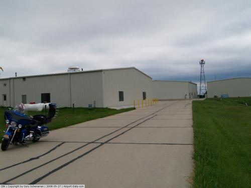
(Click on the photo to enlarge) |
 |
(Click on the photo to enlarge) |
 |
(Click on the photo to enlarge) |
 |
(Click on the photo to enlarge) |
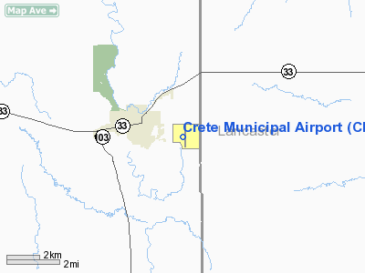
Location & QuickFacts
| FAA Information Effective: | 2008-09-25 |
| Airport Identifier: | CEK |
| Airport Status: | Operational |
| Longitude/Latitude: | 096-55-32.5513W/40-37-06.1562N
-96.925709/40.618377 (Estimated) |
| Elevation: | 1500 ft / 457.20 m (Surveyed) |
| Land: | 211 acres |
| From nearest city: | 2 nautical miles E of Crete, NE |
| Location: | Saline County, NE |
| Magnetic Variation: | 05E (2000) |
Owner & Manager
| Ownership: | Publicly owned |
| Owner: | Crete Arpt Auth
ROBERT QUICK CHMN ARPT AUTH, PHONE 402-826-3663. |
| Address: | Po Box 86
Crete, NE 68333-0086
CITY OF CRETE, NEBRASKA |
| Phone number: | 402-826-3663 |
| Manager: | Pat Dennison |
| Address: | P.o. Box 14, Crete Aviation
Crete, NE 68333-0014 |
| Phone number: | 402-826-4402
WWW.CRETEAVIATION.COM |
Airport Operations and Facilities
| Airport Use: | Open to public |
| Wind indicator: | Yes |
| Segmented Circle: | Yes |
| Control Tower: | No |
| Lighting Schedule: | DUSK-DAWN |
| Beacon Color: | Clear-Green (lighted land airport) |
| Landing fee charge: | No |
| Sectional chart: | Omaha |
| Region: | ACE - Central |
| Boundary ARTCC: | ZMP - Minneapolis |
| Tie-in FSS: | OLU - Columbus |
| FSS on Airport: | No |
| FSS Toll Free: | 1-800-WX-BRIEF |
| NOTAMs Facility: | OLU (NOTAM-d service avaliable) |
| Federal Agreements: | NGY |
Airport Communications
| CTAF: | 122.800 |
| Unicom: | 122.800 |
Airport Services
| Fuel available: | 100LLA MOGAS
FOR SVC AFTER HRS (402) 826-3912. |
| Airframe Repair: | MAJOR |
| Power Plant Repair: | MAJOR |
| Bottled Oxygen: | NONE |
| Bulk Oxygen: | NONE |
Runway Information
Runway 13/31
| Dimension: | 3370 x 150 ft / 1027.2 x 45.7 m |
| Surface: | TURF, Fair Condition |
| |
Runway 13 |
Runway 31 |
| Longitude: | 096-55-51.6204W | 096-55-20.9050W |
| Latitude: | 40-37-20.1109N | 40-36-56.4276N |
| Elevation: | 1491.00 ft | 1496.00 ft |
| Alignment: | 127 | 127 |
| Traffic Pattern: | Left | Left |
| Obstruction: | 27 ft tree, 1100.0 ft from runway, 40:1 slope to clear | , 50:1 slope to clear |
|
Runway 17/35
| Dimension: | 4201 x 75 ft / 1280.5 x 22.9 m |
| Surface: | CONC, Fair Condition |
| Weight Limit: | Single wheel: 28000 lbs.
Dual wheel: 48000 lbs. |
| Edge Lights: | Medium |
| |
Runway 17 |
Runway 35 |
| Longitude: | 096-55-29.4319W | 096-55-29.7163W |
| Latitude: | 40-37-25.2173N | 40-36-43.7049N |
| Elevation: | 1499.00 ft | 1479.00 ft |
| Alignment: | 127 | 0 |
| Traffic Pattern: | Left | Left |
| Markings: | Non-precision instrument, Good Condition | Non-precision instrument, Good Condition |
| Crossing Height: | 26.00 ft | 35.00 ft |
| VASI: | 2-box on left side | 2-box on left side |
| Visual Glide Angle: | 3.00° | 3.00° |
| Obstruction: | 18 ft road, 700.0 ft from runway, 27:1 slope to clear | 23 ft tree, 543.0 ft from runway, 260 ft right of centerline, 14:1 slope to clear |
|
Radio Navigation Aids
| ID |
Type |
Name |
Ch |
Freq |
Var |
Dist |
| LN | NDB | Potts | | 385.00 | 06E | 10.7 nm |
| BJU | NDB | Big Blue | | 248.00 | 06E | 16.2 nm |
| SWT | NDB | Seward | | 269.00 | 06E | 16.9 nm |
| HWB | NDB | Shaw | | 263.00 | 06E | 22.6 nm |
| FBY | NDB | Fairbury | | 293.00 | 06E | 28.7 nm |
| FMZ | NDB | Beklof | | 392.00 | 07E | 29.4 nm |
| JYR | NDB | York | | 257.00 | 06E | 35.7 nm |
| AHQ | NDB | Wahoo | | 400.00 | 07E | 40.2 nm |
| HJH | NDB | Hebron | | 323.00 | 06E | 41.4 nm |
| MYZ | NDB | Marysville | | 341.00 | 06E | 47.9 nm |
| AFK | NDB | Nebraska City | | 347.00 | 05E | 48.6 nm |
| BIE | VOR | Beatrice | | 110.60 | 07E | 20.6 nm |
| LNK | VORTAC | Lincoln | 108X | 116.10 | 09E | 20.2 nm |
| PWE | VORTAC | Pawnee City | 071X | 112.40 | 05E | 41.4 nm |
Images and information placed above are from
http://www.airport-data.com/airport/CEK/
We thank them for the data!
| General Info
|
| Country |
United States
|
| State |
NEBRASKA
|
| FAA ID |
CEK
|
| Latitude |
40-37-04.500N
|
| Longitude |
096-55-29.600W
|
| Elevation |
1499 feet
|
| Near City |
CRETE
|
We don't guarantee the information is fresh and accurate. The data may
be wrong or outdated.
For more up-to-date information please refer to other sources.
|
|