|
 |
|
||||
|
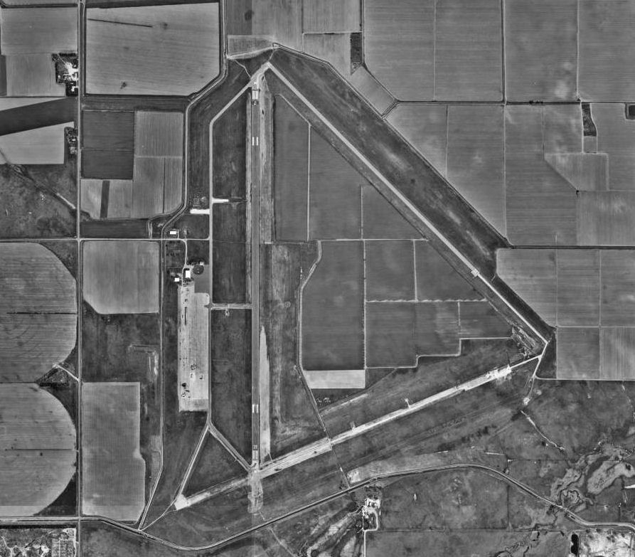
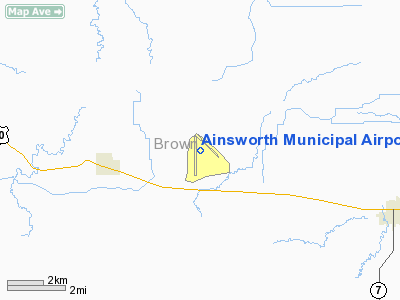
Ainsworth Municipal Airport (IATA: ANW, ICAO: KANW, FAA LID: ANW) is a public use airport located six nautical miles (11 km) northwest of the central business district of Ainsworth, in Brown County, Nebraska, United States. It is a publicly owned airport owned and managed by the Ainsworth Airport Authority. HistoryAinsworth Municipal Airport was constructed by the United States Army Air Force between August and November 1942. The 2,403-acre (9.72 km) site is bordered by farm land on the west and north, Sand Draw on the east, and Highway 20 on the south. A total of sixty four buildings were constructed at what would be known as Ainsworth Army Airfield. To construct the base, once land was acquired through condemnation and purchase from seven local landowners, laborers were hired from as far away as Omaha and Sioux City. Two hundred Native Americans from the Pine Ridge Reservation in South Dakota came to Ainsworth and were put on the payroll as laborers as well. Before the construction was completed, a total of 1,200 workers came to build the Airfield. By November 1942, the laborers had completed all housing at the base, and a railroad spur was built from the existing Chicago Northwestern Railroad several miles to the south. These tracks brought most of the supplies for the base, including building materials, food, and coal. The 2,496-acre (10.10 km) field included three 7,300 x 150-foot (46 m) concrete runways, a hangar, warehouse, repair and machine shops, link and bomb trainers, Norden bombsite vaults, and barracks for over 600 officers and enlisted men. Ainsworth AAF was activated on 30 November 1942 as one of eleven United States Army Air Force training bases in Nebraska. The base was under the command of the 353d Army Air Force Base Unit of the Second Air Force, based at Colorado Springs AAF Colorado. The 4315th Army Air Force Base Unit commanded the support elements at Ainsworth as part of Air Technical Service Command. Ainsworth was a satellite field of Rapid City Army Air Base, South Dakota. The primary objective of this facility was to train air crews of 540th and 543rd Bombardment Squadrons of the 383d Bombardment Group based at Rapid City Army Airfield for training with Boeing B-17 Flying Fortress aircraft before being sent to the European Theater. The 540th and 543rd remained at Ainsworth between December 1942 to April 1943. Bomber crews practiced bombing runs over the wildlife refuge in Cherry County, the next county to the west. Other units that trained at Ainsworth during the war were:
Also, aircraft camouflage experiments were also conducted at the field. When the facility was fully manned, there were a total of 544 enlisted men and 112 officers who lived on the base. Married personnel lived in Long Pine, Ainsworth and Johnstown. The base closed on 31 December 1945. Following the withdrawal of the military personnel, the base was closed down except for civilians who manned the Fire Department and the Weather Squadron. In 1946, a year after the end of World war II, the United States Army Corps of Engineers issued a Revokable License to the City of Ainsworth for commercial aircraft operations at the Airfield. Ainsworth AAF was declared surplus property in 1948, and the City of Ainsworth received title to the Airfield for use as a municipal airport. By late 1948, Ainsworth Municipal Airport was used for charter flights, aircraft rental, flight lessons and a maintenance shop. In the mid 1980s the National Scientific Balloon Facility rented space at Ainsworth for periodic balloon missions. By the late 1980s, the Ainsworth Airport discontinued these services due to the depressed local economy. Currently the Ainsworth Municipal Airport, owned by the city of Ainsworth, is overseen by the Airport Authority, which provides basic services, with an airport manager who oversees airport activities such as fuel sales, hangar rental, tie-downs, weather station operation, aircraft communications arid flight plan design. Approximately 1,300 acres (5.3 km) of farm land and pasture is rented out to area farmers. Today there are a handful of buildings remaining from the World War II–era at the airport. One of the aircraft hangars is still in use, a supply warehouse , the bombardier training building and the bombsight building. In addition, aircraft taxiways, hardstands, aprons, runways and roads exist in various states of repair. Facilities and aircraftAinsworth Municipal Airport covers an area of 2,493 acres (1,009 ha) at an elevation of 2,589 feet (789 m) above mean sea level. It has two asphalt paved runways: 17/35 is 6,824 by 110 feet (2,080 x 34 m) and 13/31 is 5,501 by 75 feet (1,677 x 23 m). It also has one helipad designated H1 which measures 50 by 50 feet (15 x 15 m). For the 12-month period ending August 19, 2008, the airport had 4,000 aircraft operations, an average of 10 per day: 99% general aviation and 1% military. The above content comes from Wikipedia and is published under free licenses – click here to read more.
Location & QuickFacts
Owner & Manager
Airport Operations and Facilities
Airport Communications
Airport Services
Runway InformationRunway 13/31
Runway 17/35
Helipad H1
Radio Navigation Aids
Remarks
Images and information placed above are from We thank them for the data!
|
||||||||||||||||||||||||||||||||||||||||||||||||||||||||||||||||||||||||||||||||||||||||||||||||||||||||||||||||||||||||||||||||||||||||||||||||||||||||||||||||||||||||||||||||||||||||||||||||||||||||||||||||||||||||||||||||||||||||||||||||||||||||||||||||||||||||||||||||||||||||||||||||||||||||||||||||||||||||||||||||||

 |
|
Copyright 2004-2024 © by Airports-Worldwide.com, Vyshenskoho st. 36, Lviv 79010, Ukraine Legal Disclaimer |