 |
|
| Troy Airport |
| IATA: none – ICAO: none – FAA LID: 57S |
| Summary |
| Airport type |
Public |
| Owner |
United States Forest Service |
| Serves |
Troy, Montana |
| Elevation AMSL |
2,017 ft / 615 m |
| Coordinates |
48°28′49″N 115°54′13″W / 48.48028°N 115.90361°W / 48.48028; -115.90361 |
| Runways |
| Direction |
Length |
Surface |
| ft |
m |
| 14/32 |
3,570 |
1,088 |
Asphalt |
| Statistics (2005) |
| Aircraft operations |
700 |
| Source: Federal Aviation Administration |
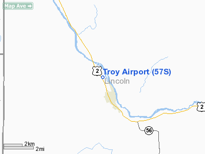
Troy Airport (FAA LID: 57S) is a public airport located one mile (2 km) northwest of the central business district of Troy, a city in Lincoln County, Montana, United States. It is owned by the United States Forest Service and is situated between U.S. Highway 2 and the Kootenai River in the Kootenai National Forest.
Facilities and aircraft
Troy Airport covers an area of 40 acres (16 ha) which contains one runway designated 14/32 with a 3,570 by 30 ft (1,088 by 9 m) asphalt surface. For the 12-month period ending August 25, 2005, the airport had 700 general aviation aircraft operations, an average of 58 per month.
The above content comes from Wikipedia and is published under free licenses – click here to read more.
Location & QuickFacts
| FAA Information Effective: | 2008-09-25 |
| Airport Identifier: | 57S |
| Airport Status: | Operational |
| Longitude/Latitude: | 115-54-12.6240W/48-28-48.7940N
-115.903507/48.480221 (Estimated) |
| Elevation: | 2017 ft / 614.78 m (Surveyed) |
| Land: | 40 acres |
| From nearest city: | 1 nautical miles NW of Troy, MT |
| Location: | Lincoln County, MT |
| Magnetic Variation: | 19E (1985) |
Owner & Manager
| Ownership: | Publicly owned |
| Owner: | Usfs
MAINTAINED BY LINCOLN COUNTY. |
| Address: | 1437 N Highway 2
Troy, MT 59935 |
| Phone number: | 406-295-4693 |
| Manager: | Dale Smith |
| Address: | Box 1036
Troy, MT 59923 |
| Phone number: | 406-295-4480 |
Airport Operations and Facilities
| Airport Use: | Open to public |
| Wind indicator: | Yes |
| Segmented Circle: | No |
| Control Tower: | No |
| Landing fee charge: | No |
| Sectional chart: | Great Falls |
| Region: | ANM - Northwest Mountain |
| Boundary ARTCC: | ZSE - Seattle |
| Tie-in FSS: | GTF - Great Falls |
| FSS on Airport: | No |
| FSS Toll Free: | 1-800-WX-BRIEF |
| NOTAMs Facility: | GTF (NOTAM-d service avaliable) |
Airport Communications
Airport Services
| Airframe Repair: | NONE |
| Power Plant Repair: | NONE |
| Bottled Oxygen: | NONE |
| Bulk Oxygen: | NONE |
Runway Information
Runway 14/32
| Dimension: | 3570 x 30 ft / 1088.1 x 9.1 m |
| Surface: | ASPH, Poor Condition
RWY SURFACE ROUGH. LOOSE GRAVEL & DEBRIS ON RWY. WEEDS GROWING THROUGH CRACKS. |
| |
Runway 14 |
Runway 32 |
| Traffic Pattern: | Left | Right |
| Markings: | Basic, Fair Condition | Basic, Fair Condition |
| Displaced threshold: | 825.00 ft | 780.00 ft |
| Obstruction: | 43 ft trees, 210.0 ft from runway, 74 ft right of centerline
APCH SLOPE 24:1 FM DSPLCD THLD.
RY 14 +5 TO +25 FT TREES WITHIN PRIMARY SURFACE BEGINNING 25 FT FM EOR TO 200 FT FM EOR 0B. | 48 ft trees, 603.0 ft from runway, 57 ft right of centerline, 8:1 slope to clear
APCH SLOPE 29:1 FM DSPLCD THLD.
+5 FT FENCE 13 FT FM EOR 0B; ROAD 145 FT FM THLD - LTD ACCESS USE. |
|
Radio Navigation Aids
| ID |
Type |
Name |
Ch |
Freq |
Var |
Dist |
| LYI | NDB | Libby | | 414.00 | 17E | 19.4 nm |
| SZT | NDB | Sandpoe | | 264.00 | 20E | 28.7 nm |
| EUR | NDB | Eureka | | 392.00 | 20E | 43.4 nm |
Remarks
- LGTD HELIPAD ON ARPT ADJACENT TO SEGMENTED CIRCLE.
- NO SNOW REMOVAL.
- PEDESTRIANS USING WALKING TRACK INVOF MOVEMENT AREA.
Images and information placed above are from
http://www.airport-data.com/airport/57S/
We thank them for the data!
| General Info
|
| Country |
United States
|
| State |
MONTANA
|
| FAA ID |
57S
|
| Latitude |
48-28-48.794N
|
| Longitude |
115-54-12.624W
|
| Elevation |
2017 feet
|
| Near City |
TROY
|
We don't guarantee the information is fresh and accurate. The data may
be wrong or outdated.
For more up-to-date information please refer to other sources.
|
|


