 |
|
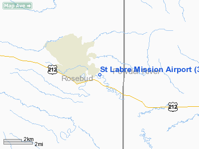
Location & QuickFacts
| FAA Information Effective: | 2008-09-25 |
| Airport Identifier: | 3U4 |
| Airport Status: | Operational |
| Longitude/Latitude: | 106-16-02.0510W/45-36-00.0000N
-106.267236/45.600000 (Estimated) |
| Elevation: | 2909 ft / 886.66 m (Estimated) |
| Land: | 17 acres |
| From nearest city: | 1 nautical miles NW of Ashland, MT |
| Location: | Rosebud County, MT |
| Magnetic Variation: | 13E (1985) |
Owner & Manager
| Ownership: | Privately owned |
| Owner: | St Labre Mission |
| Address: |
Ashland, MT 59003 |
| Phone number: | 406-784-4500 |
| Manager: | Pat Dennis |
| Address: | Po Box 77
Ashland, MT 59003 |
| Phone number: | 406-78-4450
CALL 406I-477-6625 AT NIGHT. |
Airport Operations and Facilities
| Airport Use: | Open to public |
| Wind indicator: | Yes |
| Segmented Circle: | No |
| Control Tower: | No |
| Landing fee charge: | No |
| Sectional chart: | Billings |
| Region: | ANM - Northwest Mountain |
| Boundary ARTCC: | ZLC - Salt Lake City |
| Tie-in FSS: | GTF - Great Falls |
| FSS on Airport: | No |
| FSS Toll Free: | 1-800-WX-BRIEF |
| NOTAMs Facility: | GTF (NOTAM-d service avaliable) |
Airport Communications
| CTAF: | 122.800 |
| Unicom: | 122.800 |
Airport Services
| Airframe Repair: | NONE |
| Power Plant Repair: | NONE |
| Bottled Oxygen: | NONE |
| Bulk Oxygen: | NONE |
Runway Information
Runway 13/31
| Dimension: | 3830 x 95 ft / 1167.4 x 29.0 m |
| Surface: | GRVL-DIRT, Good Condition |
| |
Runway 13 |
Runway 31 |
| Traffic Pattern: | Left | Left |
| Obstruction: | 42 ft tree, 339.0 ft from runway, 90 ft left of centerline, 8:1 slope to clear | 5 ft tree, 38.0 ft from runway, 10 ft left of centerline, 7:1 slope to clear |
|
Radio Navigation Aids
| ID |
Type |
Name |
Ch |
Freq |
Var |
Dist |
| BDX | NDB | Broadus | | 335.00 | 15E | 37.4 nm |
| FOR | NDB | Forsyth | | 236.00 | 14E | 41.6 nm |
| MLS | VORTAC | Miles City | 058X | 112.10 | 15E | 48.8 nm |
Remarks
- VEHICLES & HORSES INVOF RY.
- 100' LIGHTED ANTENNA 1/2 MILE SW OF ARPT ON HILL.
- NUMEROUS TREES ON E SIDE OF RY FULL LENGTH TO +60 FT IN TRANSITIONAL SURFACES.
- RY 31 -8' TERRAIN DROPOFF BEGINNING 35' FM EOR WITH DENSE BRUSH.
- RY 13 HAS -10 FT TERRAIN DROPOFF BEGINNING 15 FT FM EOR WITH DENSE BRUSH CREEK.
- HAY BALES & FARM EQUIP ADJACENT TO RY.
Images and information placed above are from
http://www.airport-data.com/airport/3U4/
We thank them for the data!
| General Info
|
| Country |
United States
|
| State |
MONTANA
|
| FAA ID |
3U4
|
| Latitude |
45-36-00.000N
|
| Longitude |
106-16-02.051W
|
| Elevation |
2909 feet
|
| Near City |
ASHLAND
|
We don't guarantee the information is fresh and accurate. The data may
be wrong or outdated.
For more up-to-date information please refer to other sources.
|
|


