|
|

|
 |
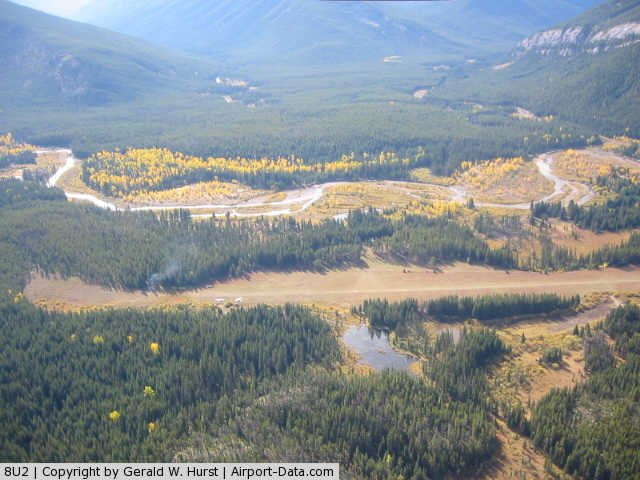
(Click on the photo to enlarge) |
Location & QuickFacts
| FAA Information Effective: | 2008-09-25 |
| Airport Identifier: | 8U2 |
| Airport Status: | Operational |
| Longitude/Latitude: | 113-15-03.2910W/48-05-14.8310N
-113.250914/48.087453 (Estimated) |
| Elevation: | 4855 ft / 1479.80 m (Estimated) |
| Land: | 49 acres |
| From nearest city: | 15 nautical miles SE of Schafer, MT |
| Location: | Flathead County, MT |
| Magnetic Variation: | 18E (1985) |
Owner & Manager
| Ownership: | Publicly owned |
| Owner: | U S Forest Service |
| Address: | Flathead National Forest
Kalispell, MT 59901 |
| Phone number: | 406-755-5401 |
| Manager: | Deb Mucklow, Dist Ranger |
| Address: | Spotted Bear Ranger Station
Hungry Horse, MT 59919 |
| Phone number: | 406-758-5376
SUMMER PHONE 406-758-5376. |
Airport Operations and Facilities
| Airport Use: | Open to public |
| Wind indicator: | Yes |
| Segmented Circle: | No |
| Control Tower: | No |
| Landing fee charge: | No |
| Sectional chart: | Great Falls |
| Region: | ANM - Northwest Mountain |
| Boundary ARTCC: | ZLC - Salt Lake City |
| Tie-in FSS: | GTF - Great Falls |
| FSS on Airport: | No |
| FSS Toll Free: | 1-800-WX-BRIEF |
| NOTAMs Facility: | GTF (NOTAM-d service avaliable) |
Airport Communications
Airport Services
| Airframe Repair: | NONE |
| Power Plant Repair: | NONE |
| Bottled Oxygen: | NONE |
| Bulk Oxygen: | NONE |
Runway Information
Runway 07/25
| Dimension: | 3200 x 60 ft / 975.4 x 18.3 m |
| Surface: | TURF, Good Condition
FIRST 400 FT RY 25 VERY ROUGH. |
| |
Runway 07 |
Runway 25 |
| Traffic Pattern: | Left | Left |
| Markings: | Nonstandard, Good Condition
RY 07/25 EAST 1800 FT MARKED WITH CONES; WEST 1400 FT UNMARKED | Nonstandard, Good Condition |
| Obstruction: | 85 ft trees, 161.0 ft from runway, 67 ft left of centerline, 1:1 slope to clear
+34' TREES ON BOTH SIDES AND ON RWY CNTRLN EXTNDD. | 42 ft trees, 179.0 ft from runway, 120 ft right of centerline, 4:1 slope to clear |
|
Radio Navigation Aids
| ID |
Type |
Name |
Ch |
Freq |
Var |
Dist |
| PLS | NDB | Polson | | 275.00 | 20E | 44.5 nm |
| CII | NDB | Choteau | | 269.00 | 17E | 46.3 nm |
| SAK | NDB | Smith Lake | | 515.00 | 18E | 48.6 nm |
| FCA | VOR/DME | Kalispell | 079X | 113.20 | 18E | 37.9 nm |
| CTB | VORTAC | Cut Bank | 091X | 114.40 | 17E | 46.3 nm |
Remarks
- LOW AREA NORTH SIDE OF RWY APROX 1100' FROM APP END RWY 25-USE CAUTION.
- WATCH FOR HORSES OR BIG GAME ANIMALS ON RY.
- TAKE OFF AND LAND RY 25 CONDITIONS PERMITTING.
- TREES AND TERRAIN IN TRANS SURFACE BOTH SIDES OF RY FULL LENGTH.
- PRIMARY PURPOSE OF A/S IS A TRAILHEAD FOR WILDERNESS AREAS.
- EST PRIOR TO 1959.
Images and information placed above are from
http://www.airport-data.com/airport/8U2/
We thank them for the data!
| General Info
|
| Country |
United States
|
| State |
MONTANA
|
| FAA ID |
8U2
|
| Latitude |
48-05-14.831N
|
| Longitude |
113-15-03.291W
|
| Elevation |
4855 feet
|
| Near City |
SCHAFER
|
We don't guarantee the information is fresh and accurate. The data may
be wrong or outdated.
For more up-to-date information please refer to other sources.
|
|