 |
|
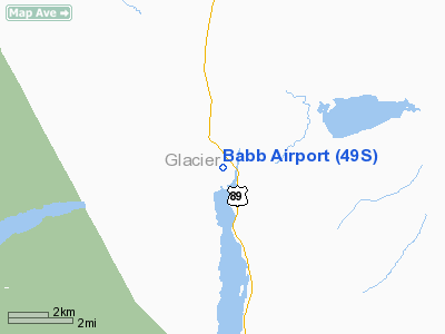
Location & QuickFacts
| FAA Information Effective: | 2008-09-25 |
| Airport Identifier: | 49S |
| Airport Status: | Operational |
| Longitude/Latitude: | 113-25-38.3500W/48-50-41.9360N
-113.427319/48.844982 (Estimated) |
| Elevation: | 4518 ft / 1377.09 m (Estimated) |
| Land: | 91 acres |
| From nearest city: | 1 nautical miles SE of Babb, MT |
| Location: | Glacier County, MT |
| Magnetic Variation: | 19E (1985) |
Owner & Manager
| Ownership: | Publicly owned |
| Owner: | Blackfeet Nation |
| Address: | Po Box 850
Browning, MT 59417 |
| Phone number: | 406-338-7179 |
| Manager: | Mt Aero Div |
| Address: | Po Box 200507
Helena, MT 59620 |
| Phone number: | 406-444-2506 |
Airport Operations and Facilities
| Airport Use: | Open to public |
| Wind indicator: | Yes |
| Segmented Circle: | No |
| Control Tower: | No |
| Landing fee charge: | No |
| Sectional chart: | Great Falls |
| Region: | ANM - Northwest Mountain |
| Boundary ARTCC: | ZLC - Salt Lake City |
| Tie-in FSS: | GTF - Great Falls |
| FSS on Airport: | No |
| FSS Toll Free: | 1-800-WX-BRIEF |
| NOTAMs Facility: | GTF (NOTAM-d service avaliable) |
Airport Communications
Airport Services
| Airframe Repair: | NONE |
| Power Plant Repair: | NONE |
| Bottled Oxygen: | NONE |
| Bulk Oxygen: | NONE |
Runway Information
Runway 14/32
| Dimension: | 3860 x 110 ft / 1176.5 x 33.5 m |
| Surface: | TURF, Fair Condition
RWY 14/32 SOFT WHEN WET. GOPHER HOLES ON RY SFC. TALL GRASS AT NORTH END |
| |
Runway 14 |
Runway 32 |
| Traffic Pattern: | Right | Right |
| Markings: | Nonstandard, Fair Condition
TIRES FADED AND OBSCURED BY WEEDS | , |
| Obstruction: | 14 ft trees, 172.0 ft from runway, 12:1 slope to clear | 4 ft fence, 66.0 ft from runway, 16:1 slope to clear |
|
Radio Navigation Aids
| ID |
Type |
Name |
Ch |
Freq |
Var |
Dist |
| 9Y | NDB | Pincher Creek | | 311.00 | 18E | 46.5 nm |
| FCA | VOR/DME | Kalispell | 079X | 113.20 | 18E | 48.2 nm |
| CTB | VORTAC | Cut Bank | 091X | 114.40 | 17E | 46.2 nm |
Remarks
- NO SNOW REMOVAL.
- LIVESTOCK ON & INVOF ARPT.
- FARM ROAD ON RY SOUTH END TO TIEDOWN AREA.
Images and information placed above are from
http://www.airport-data.com/airport/49S/
We thank them for the data!
| General Info
|
| Country |
United States
|
| State |
MONTANA
|
| FAA ID |
49S
|
| Latitude |
48-50-41.936N
|
| Longitude |
113-25-38.350W
|
| Elevation |
4518 feet
|
| Near City |
BABB
|
We don't guarantee the information is fresh and accurate. The data may
be wrong or outdated.
For more up-to-date information please refer to other sources.
|
|


