 |
|
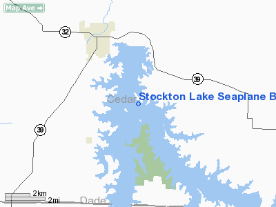
Stockton Lake Seaplane Base |
Location & QuickFacts
| FAA Information Effective: | 2008-09-25 |
| Airport Identifier: | 2M5 |
| Airport Status: | Operational |
| Longitude/Latitude: | 093-45-30.7530W/37-39-00.1430N
-93.758543/37.650040 (Estimated) |
| Elevation: | 867 ft / 264.26 m (Estimated) |
| Land: | 0 acres |
| From nearest city: | 1 nautical miles E of Stockton, MO |
| Location: | Cedar County, MO |
| Magnetic Variation: | 04E (1990) |
Owner & Manager
| Ownership: | Publicly owned |
| Owner: | Us Army Corps Of Engineers
U.S. ARMY CORPS OF ENGINEERS OFFICE MON-FRI 0730-1600. |
| Address: | 700 Federal Bldg
Kansas City, MO 64106-2896 |
| Phone number: | 816-389-3342 |
| Manager: | Thomas Long
OPERATIONS PROJECT MANAGER |
| Address: | 16435 E. Stockton Lake Dr.
Stockton, MO 65785-0632 |
| Phone number: | 417-276-3113 |
Airport Operations and Facilities
| Airport Use: | Open to public |
| Segmented Circle: | No |
| Control Tower: | No |
| Sectional chart: | Kansas City |
| Region: | ACE - Central |
| Boundary ARTCC: | ZKC - Kansas City |
| Tie-in FSS: | COU - Columbia |
| FSS on Airport: | No |
| FSS Toll Free: | 1-800-WX-BRIEF |
| NOTAMs Facility: | COU (NOTAM-d service avaliable) |
Airport Communications
Runway Information
Runway ALL/WAY
| Dimension: | 15000 x 2000 ft / 4572.0 x 609.6 m |
| Surface: | WATER, |
| |
Runway ALL |
Runway WAY |
| Traffic Pattern: | Left | Left |
|
Radio Navigation Aids
| ID |
Type |
Name |
Ch |
Freq |
Var |
Dist |
| ILJ | NDB | Willard | | 254.00 | 03E | 26.0 nm |
| LLU | NDB | Spring River | | 356.00 | 05E | 28.1 nm |
| EAD | NDB | Nevada | | 209.00 | 06E | 28.7 nm |
| GLY | NDB | Golden Valley | | 388.00 | 04E | 42.7 nm |
| PTS | NDB | Pittsburg | | 365.00 | 05E | 47.8 nm |
| FSK | NDB | Fort Scott | | 379.00 | 05E | 48.7 nm |
| SGF | VORTAC | Springfield | 116X | 116.90 | 04E | 26.9 nm |
Remarks
- SEAPLANES MAY NOT BE OPERATED AT STOCKTON LAKE SS-SR.
- DEBRIS ON & INVOF LAKE DURING FLOODING.
- NO BUOYS SHOWING LANDING AREA.
- CALL FOR ICE CONDITIONS IN WINTER MONTHS.
- PRVDD EACH SEALANE APCH IS MAINTAINED FOR A 20:1 GLIDE SLOPE.
Images and information placed above are from
http://www.airport-data.com/airport/2M5/
We thank them for the data!
| General Info
|
| Country |
United States
|
| State |
MISSOURI
|
| FAA ID |
2M5
|
| Latitude |
37-39-00.143N
|
| Longitude |
093-45-30.753W
|
| Elevation |
867 feet
|
| Near City |
STOCKTON
|
We don't guarantee the information is fresh and accurate. The data may
be wrong or outdated.
For more up-to-date information please refer to other sources.
|
|


